MT HOOD SNOW FORECAST

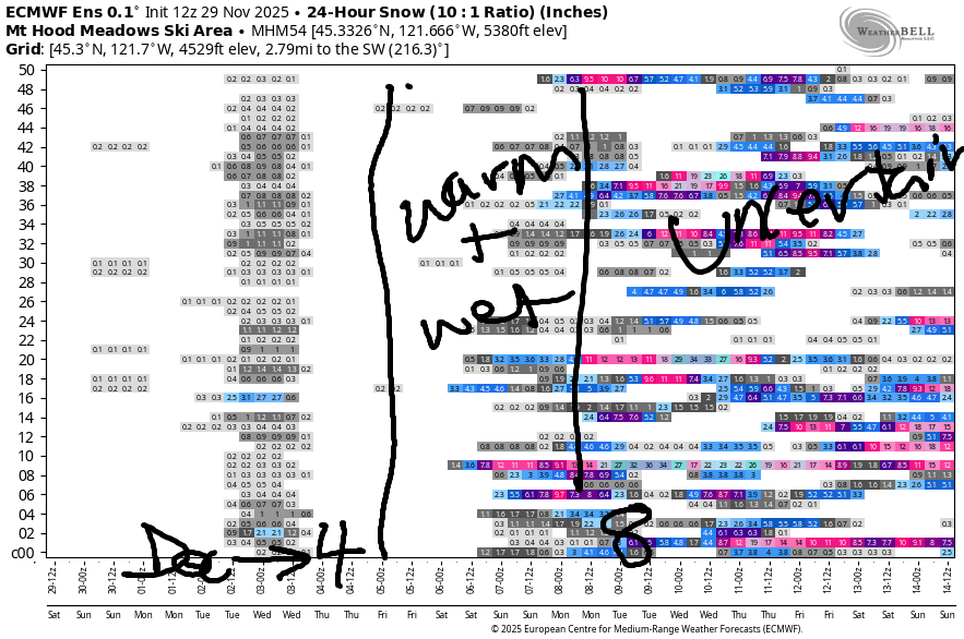
Hey skiers and snowboarders! Apologies for the late forecast today. Or maybe it’s just an early forecast for tomorrow – eventually the forecast (theoretically) switches to the evening during ski season. Speaking of, it seems unlikely ski season will start in the next two weeks. While there are periods of colder weather in the next couple of weeks, the bulk of the precipitation looks to come in too warm.
Let’s look at the next few days: there really isn’t much to see Saturday through Wednesday: The snow level Saturday drops from 8000′ in the morning to 1000′ overnight. A trace of snow is possible overnight. Wind: S 10-20 in the morning, W 10 in the afternoon, and NW 10 after midnight.
Sunday’s Mt Hood snow forecast
Sunday will be clear and then partly high overcast. The free air freezing level will be 0′ in the morning, 5000′ in the afternoon, and 8000′ after midnight. No snow. No rain. Less than 15mph of wind for the 24 hour period.
Monday’s Mt Hood snow forecast
Monday looks warmer – freezing level of 8000′ – with partly cloudy sky and NW wind that builds from 10mph in the morning to 30mph overnight.
Extended mt hood snow forecast
A trace of snow is possible Tuesday into Wednesday as a weak system moves in. Snow level: 4500′ dropping to 1500′. Wind: NW 30 in the morning, NW 20 in the afternoon, and N 10 after midnight. Additional moisture is forecast starting Thursday, but temps at 850mb (~5000′) are forecast to be well above freezing at least through the weekend and potentially for longer; uncertainty skyrockets starting Sunday, but the mean forecast temp is above 0C at 850mb. Let’s hope that changes! I want to play in the snow, and I bet you do too!

Was that helpful? I knew it was! Guess what? All of this crucial work – from your personal wind and snow reports to the invaluable TATAS updates – is made possible by my relentless efforts. Maintaining this labor of love isn’t easy. Each daily forecast takes hours. Website hosting, weather model access, and back-end admin work takes time and money. That’s where you come in.
YOUR CONTRIBUTION MAKES A DIFFERENCE
- SUPPORT ACCURATE, HYPER-LOCAL WEATHER FORECASTING
- ENABLE ACCESS FOR ALL, EVEN THOSE WITH LESS MEANS
- SUPPORT A COOL HUMAN WHO WORKS HARD SO YOU CAN PLAY
Take a moment to click one of the buttons below. Donate $19.99 or more (how much does this forecast enhance your life?) and get the email in your inbox. Whether it’s a renewing subscription (auto-renew) or a one-time donation, every contribution makes a real difference. Help me keep this labor of love alive, so we can all continue playing, commuting, and living in the Gorge with peace of mind and the best weather forecasts possible. Thank you!


Hood River, Oregon 97031


GORGE WIND FORECAST
If you’re still seeing yesterday’s and it’s after 9am, try opening this in an incognito window

today’s gorge wind forecast
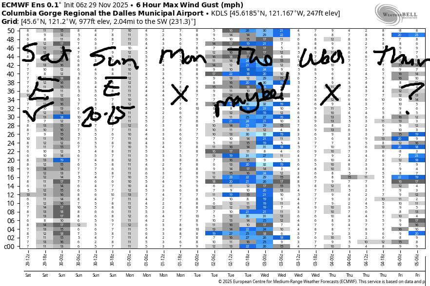
Hi friends! It’s an east wind day here in the Gorge, as you probably figured out by now. We’ll have lighter easterlies Sunday into Monday and then a switch to westerlies on Monday afternoon. Moderate west wind sticks around on Tuesday, and then it’s back to calm conditions for Wednesday.
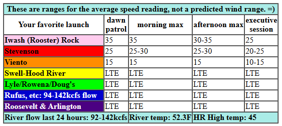
Saturday brings easterlies at 30-35mph at Stevenson and Iwash (Rooster), eventually fading to 25mph at Iwash and 20-25mph at Stevenson. River flow over the last 24 hours was 92-142kcfs, river temp is 52.3F, and high temp forecast is 45F.
RIVER FLOW FOR SITES BETWEEN AVERY (EAST OF THE DALLES) AND RUFUS: CLICK HERE FOR JOHN DAY DAM FLOW.
RIVER FLOW FOR SITES BETWEEN STEVENSON AND DOUG’S BEACH (WEST OF THE DALLES): CLICK HERE FOR THE DALLES DAM FLOW

tomorrow’s gorge wind forecast
Sunday starts with 25mph at Iwash and 15-20mph at Stevenson. Iwash holds at 20-25mph all day. Stevenson rises to 20-25mph then dips to 15-20mph. High temp: 45F with sunshine. Monday starts with E 15mph at both Iwash and Stevenson. The wind goes calm midday and switches to light westerly mid to late afternoon.
extended Gorge wind forecast

A weak system moves through on Tuesday. Weak high pressure builds off the coast. If we’re lucky, we’ll see a 20mph west wind day. Fingers crossed. Wednesday currently looks calm or nearly so. Okay. That’s it for today. Hope to see you out there soon!
BARE BONES HOOD RIVER WEATHER FORECAST
Clouds this morning. Mostly cloudy later. Temps hang in the mid 40s. Light easterlies. No rainbows. Sunday will be partly Nothing then mostly clear with a few high clouds. Temps start in the low 30s and rise to the mid 40s. Light easterlies. No rainbows. Monday will be partly Nothing then partly cloudy. Temps start near 30 and rise to the mid 40s. Light easterlies then light westerlies. No rainbows.
TEMIRA’S AWESOME TRAVEL ADVISORY SERVICE
HYPERLOCAL WEATHER FORECAST FOR THE COLUMBIA GORGE
THE DALLES, HOOD RIVER, WHITE SALMON, TROUT LAKE, STEVENSON, CASCADE LOCKS, PARKDALE, ODELL, HUSUM, BZ, MILL A, WILLARD, GOLDENDALE, RUFUS, ARLINGTON, boardman

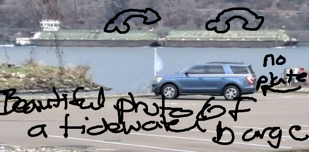
Hey neighbors! Goodness gracious am I late with the forecast today. The roads have just been a mess all day with slippery vehicles: a gray suburban, a black suburban, a white van, and a blue Ford Exhibition. It’s just hard to get anything done when there are so many vehicles around without license plates. At least the roads aren’t covered in snow and ice while folks are trying to keep track of things!
Glenwood this morning
Well anyway, you kinda know what today’s weather will be by now. If you’re curious, Glenwood started the day at 31F. The rest of us will get to taste that sort of chill the next couple of mornings. It is worth mentioning that there could be a few snowflakes east of the Arlington Triangle tonight. But not here. No, no snow for you! Not yet, anyway!
Sunday’s Gorge weather forecast
Sunday starts off in the upper 20s to low 30s away from the river and slightly warmer temps near it thanks to a river-hugging Nothing cloud. In the windy zones: low 40s. Away from the river: clear sky to start. Afternoon brings some high clouds in from the west, and that probably results in a colorful wintry sunset. Temps finish up in the mid 40s. Wind: 20-25mph all day near Iwash (petzl) Rock and Stevenson.
Extended Gorge weather forecast
Monday looks similar: 26-33 to start, mid 40s to finish. High clouds and a partial Nothing in the morning give way to partly cloudy sky later. The usual spots have east wind at 15mph in the morning. Afternoon: light westerlies all through the Gorge. A tiny bit of drizzle is possible Tuesday. Wednesday looks boring. Active weather returns on Thursday. By “active”, I mean wet. It’s not clear yet how wet it will be, but it does look pretty warm, warm enough to keep the passes free of accumulating snow. Safe travels. -TATAS
HEY! DON’T STOP READING! Is this community-focused forecast helpful to you? It sure is! It takes me a couple hours a day to write. Please join your friends and neighbors in contributing to keep it going. Venmo: @thegorgeismygym PayPal: twomirrors@gmail.com USPS: Temira / PO Box 841 / Hood River, Oregon 97031 You can test out the forecast subscription for a few days for free by signing up below. Easy! Do it!
JONES BEACH, SAUVIE ISLAND, & COAST FORECAST
ON WINTER VACATION UNLESS DESPERATELY NEEDED.


