

GORGE WIND FORECAST
If you’re still seeing yesterday’s and it’s after 9am, try opening this in an incognito window
today’s gorge wind forecast
Hi friends! It’s Saturday. Get yourself on the river today and wear yourself out so you can take full advantage of tomorrow’s rest day. Speaking of that Sunday rest day, I’m going to take advantage of it by sleeping in and not writing a morning forecast. I might write an evening one, tho…maybe… I’ll definitely write one Monday! Anyway, today’s forecast shall suffice, because the picture is pretty clear from Sunday on through next week. For those of you traveling to the Gorge, it might just be a good week to travel. We’ll talk more in a bit about the level of uncertainty. In the meantime…
Today’s PSAs: first, today is the Double-Damned sailboat race from Cascade Locks to The Dalles. Watch out for big boats! Next, I got a report this morning (that I can’t confirm using search engines) that The Hook is closed due to water being out of compliance. I was also unable to confirm whether water is back in compliance for the Doug’s/Rowena zone. That is your Poopy Water Update for today. One last thing: Philip Soltsiak is offering a free freestyle windsurfing clinic today at the Hood River Waterfront Park at
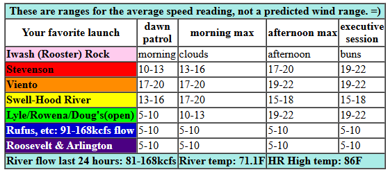
It’s Saturday, and pressures started at 30.16/30.08/30.07 for gradients of 0.08 (PDX-DLS) and 0.01 (DLS-PSC). The metro area was clear, and it’ll stay that way. We’ll see just enough “oomph” today for the Stevenson-Mosier stretch this morning and for the Rowena zone this afternoon. Early wind will be 13-16mph from Stevenson to Swell with 10-13mph near Hood River and less than 10mph to the east. The wind rises to 17-20mph late morning from Stevenson to Hod River with 14-17mph at Mosier. Afternoon: 18-22mph from Stevenson to Avery with Swell-Hood River falling to 15-18mph. River flow over the last 24 hours was 81-168kcfs, river temp is 71.1F, and high temp forecast is 86F for Hood River.
RIVER FLOW FOR SITES BETWEEN AVERY (EAST OF THE DALLES) AND RUFUS: CLICK HERE FOR JOHN DAY DAM FLOW.
RIVER FLOW FOR SITES BETWEEN STEVENSON AND DOUG’S BEACH (WEST OF THE DALLES): CLICK HERE FOR THE DALLES DAM FLOW

tomorrow’s gorge wind forecast
Sunday looks hot, clear, and not very windy. The day starts with westerlies at 11-14mph from Viento to Swell. The wind drops below 10mph for most of the day. It returns at 10-13mph from Stevenson to Hood River late afternoon or early evening. High temp: 96F and muggy. See why I’m taking a day off?
extended Gorge wind forecast
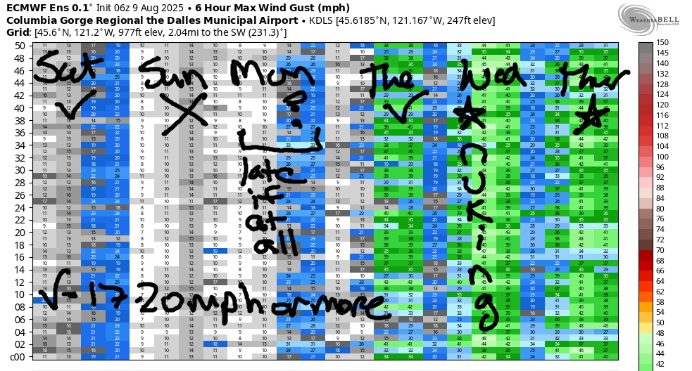
The pattern starts to shift on Monday, but it’s probably not going to shift early enough to drive wind speeds way up. The day starts calm, muggy, and warm. By late morning or early afternoon, westerlies rise to 13-16mph from Stevenson to The Dalles. By late afternoon, we’ll have 17-20mph from Stevenson to Doug’s. Rufus joins in the evening. All that said, the breakdown of these heat waves often happens later than expected, so don’t be surprised if the wind doesn’t return until the evening or even not until the night. I won’t be surprised if that happens! Low probability day for sure. High temp: 98F and sunny.
Quite a bit of range is present in the forecast for Tuesday, but it’s almost certainly going to be windy enough for you and you and you and you; as of this morning, we’re looking at 24-27mph focused at the Hatch early and from Lyle to Rufus later. That said… we won’t have any marine cloud support. If the metro area over-performs in the heat category, the wind will be lighter.
Nothing looks “light” about Wednesday and Thursday: marine clouds settle in on the west side and temps stay hot in the desert. This is “The Cooldown You Were Looking For”. As of this morning, Wednesday looks like a real nuker all the way from Viento to Rufus. Thursday also looks strong. As we move towards Friday and next weekend, temperature range increases and uncertainty rises. That said… ensembles are insisting it will be windy at least through next weekend. Take full advantage of the rest possibilities this weekend if your calendar is open enough to play next week. Have a great day out there today. See you on the Nch’i Wana!
Was that helpful? I knew it was! Guess what? All of this crucial work – from your personal wind and snow reports to the invaluable TATAS updates – is made possible by my relentless efforts. Maintaining this labor of love isn’t easy. Each daily forecast takes hours. Website hosting, weather model access, and back-end admin work takes time and money. That’s where you come in.
YOUR CONTRIBUTION MAKES A DIFFERENCE
- SUPPORT ACCURATE, HYPER-LOCAL WEATHER FORECASTING
- ENABLE ACCESS FOR ALL, EVEN THOSE WITH LESS MEANS
- SUPPORT A COOL HUMAN WHO WORKS HARD SO YOU CAN PLAY
Take a moment to click one of the buttons below. Donate $19.99 or more (how much does this forecast enhance your life?) and get the email in your inbox. Whether it’s a renewing subscription (auto-renew) or a one-time donation, every contribution makes a real difference. Help me keep this labor of love alive, so we can all continue playing, commuting, and living in the Gorge with peace of mind and the best weather forecasts possible. Thank you!


Hood River, Oregon 97031


JONES BEACH, SAUVIE ISLAND, & COAST FORECAST
Wind northerly unless otherwise indicated. For coast, it’s North/Central/South with the “central” at approximately Florence. Swell forecast from NWS for central coast. Jones: westerly unless otherwise stated. Sauvie Island: northerly unless otherwise stated. Coast Saturday: 20/25/35, W swell 3′ at 11 seconds. Sunday: 10-25/25/NNE25-30, W 6′ @ 10. Monday: 10/15/25, NW 8′ @ 10 and SW 2′ @ 17. Jones Saturday: 14-17. Sunday: 11-14. Monday: 23-26. Sauvie Island Saturday: 14-17. Sunday: 16-19. Monday: 11-14.
BARE BONES HOOD RIVER WEATHER FORECAST
High clouds with filtered sun all day. Temps start in the mid 60s and rise to the mid 80s. Moderate westerlies. No rainbows. Sunday will be sunny. Temps start in the low 60s and rise to the mid 90s. Muggy. Very light west wind. No rainbows. Monday will be sunny. Temps start in the upper 60s and rise to the upper 90s. Muggy. Calm wind early. Moderate westerlies later. No rainbows.
TEMIRA’S AWESOME TRAVEL ADVISORY SERVICE
HYPERLOCAL WEATHER FORECAST FOR THE COLUMBIA GORGE
THE DALLES, HOOD RIVER, WHITE SALMON, TROUT LAKE, STEVENSON, CASCADE LOCKS, PARKDALE, ODELL, HUSUM, BZ, MILL A, WILLARD, GOLDENDALE, RUFUS, ARLINGTON, boardman

Good morning, neighbors! A hot few days are on tap. Let today literally be your warm-up for the incoming heat wave. NWS Portland issued an “Extreme Heat Warning”, and NWS Pendleton has us under an “Extreme Heat Watch”. The former is when you walk around warning people that’ it’s hot, which they already know because they’re sweating. The latter is when you are instructed to wear a watch that displays the outside temperature.
glenwood this morning
Looking at our Saturday morning, we see Glenwood 11 degrees warmer than it was yesterday. Yesterday was something special there! Today it was 47 degrees, and everyone was back to sipping Buck Naked Coffee (it’s a brand, I swear), while watching the young bucks practice twerking at the Saturday morning dance class at the Glenwood store. Those are young bucks (deer), by the way, not young human bucks. Get your mind out of the gutter.
saturday’s gorge weather forecast
The rest of us started out Saturday cool enough to open the windows and doors and marvel at Ma Nature’s AC. By afternoon, temps rise to the mid 80s (west) and low 90s (The Dalles eastward to the watermelon zones). West wind will be 15-20mph all day from Stevenson to Hood River. The wind spreads east to The Dalles in the afternoon as Mother Nature frosts the land with a slightly-cooling breeze. Speaking of frosting… I had some birthday cake last night, and boy do I love frosting! Thin high clouds stick around all day and set us up for a colorful sunset. Also on tap for today: the moisture tap – dewpoints rise to the upper 50s this afternoon. Expect a sticky, stinky armpit sort of day.
sunday’s gorge weather forecast
Your pits will be all fired up on Sunday as heat and humidity combine to make a Carly-happy day. After a 60-something degree start (record high low for Hood River is 68, and is not in danger), temps rise to the mid 90s (west), low triple digits (The Dalles), and upper 90s (watermelon patches out east). Clouds: no. Wind: very little. Westerlies will be 10-15mph between Viento and White Salmon early, less than 10mph midday, and 10-15mph from Stevenson to Hood River in the evening. Dewpoints rise to 61F on the west side and drop from 55F to 45F on the east side.
monday’s gorge weather forecast
Monday starts calm, clear, hot, and muggy. The record high-low for Hood River that morning is 66 degrees. It’s in danger of falling. Afternoon temps rise to the upper 90s (west) and low triple digits from The Dalles eastward. Wind will be dead calm to start. It rises to 15-20mph between Stevenson and Rufus late in the day. If we get really, really lucky, onshore flow will increase beyond this forecast in the afternoon and start to cool us off. But we probably won’t get that lucky.
extended gorge weather forecast
Tuesday starts off hot thanks to west wind and high humidity. We’ll probably break the record high-low that day – it’s only 65 degrees, which is known as the “Medicare Temperature”. The record for that day is 69F, which is known as the “69 temperature”. You probably know what that is, even if you’re Ace. Go ahead and plan for it. High temps will be down to the low 90s (west), upper 90s (The Dalles), and low triple digits (way out east). In response to the combo of cooler air to the west and hotter air to the east, west wind rises to 25-30mph.
Temps drop further on Wednesday and Thursday (especially Thursday, when it’ll be downright cool). In response, westerlies increase to what the Wind Johnnies call “NUKIN’”, as in “Fukitznükin”, which was a sticker I had on my 1982 Volvo station wagon when I was in high school. Looking deeper into the future… next week looks a touch cooler than normal, which should still be plenty warm. Because it’s summer. And summer is warm. I’m pretty stoked on this forecast. I hope you are too! Safe travels. -TATAS
HEY! DON’T STOP READING! Is this community-focused forecast helpful to you? It sure is! It takes me a couple hours a day to write. Please join your friends and neighbors in contributing to keep it going. Venmo: @thegorgeismygym PayPal: twomirrors@gmail.com USPS: Temira / PO Box 841 / Hood River, Oregon 97031 You can test out the forecast subscription for a few days for free by signing up below. Easy! Do it!
