

MT. HOOD WEATHER FORECAST
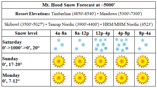
Hey skiers and snowboarders! It’s snowing up on the slopes this morning, and the plan is for snow to continue all day and most of tonight. Free refills! Okay, it won’t snow that hard, but it sure is good conditions up there: mostly packed powder groom with shallow dry powder off the groom. Do watch out for moguls and scoured spots – we’ll need several feet of snow to completely erase the remnants of the January dry spell. Nordic: blue wax, and better for classic than skate today with the accumulating snow. There’s a race at Meadows this morning, and the Teacup Classic race takes place on Sunday. Plan accordingly!
SATURDAY
Today’s weather, like I said, will be snowy all day. The snow level will be 0′ this morning, 1000′ this afternoon, and 0′ overnight with temps right around 20F all day long. About 0.2” water equivalent (WE) is forecast during the day for 2-3” additional snow atop the 4” that already fell. Overnight, another 0.2” to 0.4” WE is forecast for 3-5” additional snowfall. Wind will be W 10-15 this morning, W 20 this afternoon, and NW 10-15 after midnight.
SUNDAY AND MONDAY
Sunday looks like a sunny day. The free air freezing level will be 0′ all day long with temps in the upper teens, maybe the low 20s if the sun helps a bit. No precip. Wind: NW 10-15 in the morning and light/variable from late morning on through the night. Spectacular! Cold, clear weather is in the cards Monday morning with some high clouds in the afternoon. The freezing level will be 0′ all day with temps ranging from the teens to low 20s depending on location, time, and elevation. Wind will be light and variable in the morning with E 5-10mph in the afternoon and E 10-15mph overnight.
TUESDAY AND BEYOND
Cold, clear, crisp, dry weather is planned for Tuesday. Temps will be in the single digits to start and won’t warm up a ton. Wind: E 10-15mph in the morning, E 20mph in the afternoon, and E 20-25mph overnight. Uncertainty in the forecast crops up starting Wednesday. About 40-50% of the ensemble members bring a system in sometime Wednesday or Thursday, and there is additional “weather” forecast for the weekend. The p-type, p quantity, wind, and everything else is going to depend on the location/path of an incoming low as well as how much moisture it can tap into. So, for now, let’s say a pattern change from cold/sunny is coming for the latter half of the week. Until then… enjoy the spectacular packed powder out there. See you on the snow.
Liking this forecast?
Was that helpful? I knew it was! Guess what? All of this crucial work – from your personal wind and snow reports to the invaluable TATAS updates – is made possible by my relentless efforts. Maintaining this labor of love isn’t easy. Each daily forecast takes hours. Website hosting, weather model access, and back-end admin work takes time and money. That’s where you come in.
YOUR CONTRIBUTION MAKES A DIFFERENCE
- SUPPORT ACCURATE, HYPER-LOCAL WEATHER FORECASTING
- ENABLE ACCESS FOR ALL, EVEN THOSE WITH LESS MEANS
- SUPPORT A COOL HUMAN WHO WORKS HARD SO YOU CAN PLAY
Take a moment to click one of the buttons below. Donate $19.99 or more (how much does this forecast enhance your life?) and get the email in your inbox. Whether it’s a renewing subscription (auto-renew) or a one-time donation, every contribution makes a real difference. Help me keep this labor of love alive, so we can all continue playing, commuting, and living in the Gorge with peace of mind and the best weather forecasts possible. Thank you!


Hood River, Oregon 97031


GORGE WIND FORECAST

Hi friends! Not much happening for a couple of days, and then we will have some entertainment-only easterlies as temps drop below freezing and stay there for a few days. For Saturday, we start with light easterlies, less than 10mph. The wind turns calm and then switches to very light westerlies this afternoon at 10mph or less. River flow over the last 24 hours was 91-141kcfs, river temp is 39.02F, and high temp forecast is in the upper 30s. Sunday starts calm and rises to E 10mph near Stevenson and only near Stevenson. High temp: upper 30s.
Monday brings somewhat stronger east wind. The day starts with 20mph at Iwash (Rooster) Rock and climbs to 25mph. Stevenson starts with 10-15mph and rises to 25mph midday before dropping back to 20mph. High temp: 34F and partly cloudy. Tuesday brings easterlies at 40-50mph with sub-freezing temps. Even stronger easterlies are possible on Wednesday with very cold temps. Let’s leave it there for now – the details actually start to get fuzzy around Wednesday, and the range only increases as we get deeper into the future. Have a great day today, and enjoy the cross training!
BARE BONES WEATHER FORECAST FOR HOOD RIVER
Light snowfall this morning gives way to partly cloudy sky this afternoon. Temps start in the low 30s and rise to the upper 30s. Light/variable wind. No rainbows. Sunday will be Nothing then partly cloudy. Temps start in the upper 20s and rise to the upper 30s. Calm wind. No rainbows. Monday starts Nothing and ends partly cloudy. Temps start in the mid 20s and rise to the mid 30s. Light easterlies. No rainbows.
TEMIRA’S AWESOME TRAVEL ADVISORY SERVICE (HYPERLOCAL WEATHER FORECAST FOR THE COLUMBIA GORGE)
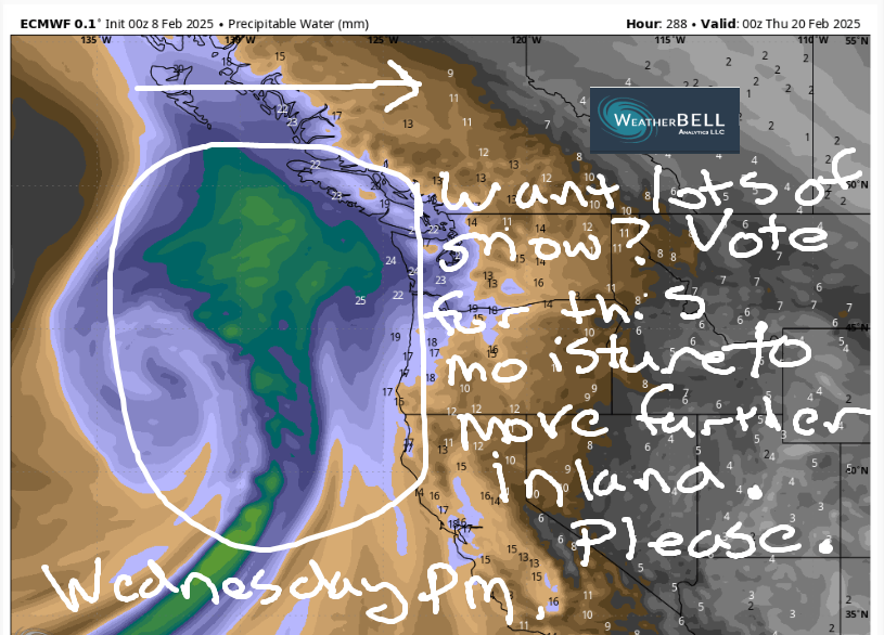
Good morning, neighbors! Light snowfall continues today, and then we fall into a colder, dry pattern for a few days. Starting Sunday night, temps will strugglebus to climb above freezing for a few days, and overnight temps will be downright frigid. Frigid is dangerous – check on your unhoused neighbors and others who might be at risk. Sometime in that Wednesday-Thursday window, we’re likely (40-65% chance) to see some snow. Beyond that, uncertainty kicks in, but we definitely have moisture of some sort planned for next weekend.
But first! Glenwood, the center of the Gorge universe. As of 7am today, it was 26 degrees in Glenwood with a dewpoint of 20 degrees, which is just a touch below average for the area this morning – pretty much all of us are below freezing. Next up, the TATAS Executive Order Of The Day: Gender diversity is real. Intersex people, trans people, and gender diverse people are real, always have been, and always will be. They shall be protected from discrimination by law, and they shall have access to healthcare just as anyone else shall.
SATURDAY
On to today’s weather… light snowfall continues on and off today as far east as Biggs until sunrise and to The Dalles into this evening. Wear a warm, waterproof jacket if you’re going to today’s pro-immigrant demonstration at Rite Aid in The Dalles. Total accumulations will be 2-3” west of Hood River, and a trace to 1” everywhere else. South Shore communities have an advantage over North Shore communities today for snow accumulation. We could see the p-type switch to snain this afternoon, but the air column above us is pretty cold, so maybe it’ll stay wet snow, aka “snain”. Watch out for icy roads everywhere. Today’s wind will be light and variable. Clouds start to dissipate in the afternoon – east of The Dalles, you know, near Amayah’s, finishes up mostly clear, and the west side finishes mostly cloudy.
SUNDAY
Thanks to some clearing overnight, Sunday starts in the mid 20s with icy roads. Most of us will be dry all day, but some morning flurries in the SW/Sherm area are totally possible, but only in the morning. By afternoon, we all should be mostly clear. Hopefully the clearing and the sunshine clears your mind of panic and gives you a clear sense of a clear path forward. Wind will be calm in the morning and E 10mph in the afternoon, but the easterlies will only be found in Stevenson, the most consistently windiest place in the Gorge (don’t you wish you knew that when you moved there?).
MONDAY-TUESDAY
Colder air starts to take hold on Monday as an Arctic front subverts any tariff or border crossing complications and pushes cold, dry Canadian air into the Gorge. Sadly, it arrives without Cheezies, but that’s okay – I’m fully stocked up. The day starts Nothing, but the incoming dry air mass turns things clear by the afternoon. Temps probably start in the low-mid 20s and rise to the low or maybe mid 30s. Easterlies pick up to 20-25mph in the usual easterly spots. That cold, dry air really settles in on Tuesday for a chilly, but partly sunny day.
WEDNESDAY AND BEYOND
Somewhere in that Wednesday-onward window, moisture arrives. Probably. It’s almost certain to fall as snow thanks to the deep cold pool in place. However, there’s so much range in the ensembles right now that there’s no way to tell how much (if any) snow we’ll get. Models are far more agreeable about a wetter system on Sunday, but there’s no way to tell at this point what Gorge temps will be like then. Don’t trust your phone telling you it’ll be above freezing – once we get as cold and dry as we will be for the middle of next week, it’s quite tough to get the cold air out of here. Stay tuned for updates. Safe travels. -TATAS
HEY! DON’T STOP READING! Is this community-focused forecast helpful to you? It sure is! It takes me a couple hours a day to write. Please join your friends and neighbors in contributing to keep it going. Venmo: @thegorgeismygym PayPal: twomirrors@gmail.com USPS: Temira / PO Box 841 / Hood River, Oregon 97031 You can test out the forecast subscription for a few days for free by clicking this link: https://subscribepage.io/YhevGc
