

MT HOOD WEATHER FORECAST
Hey skiers and snowboarders! Here’s your Mt Hood weather: Today’s the calm between the storms – just a little snow is forecast. Starting tomorrow, the weather turns favorable for big snow accumulation of the dense, heavy snow type. A couple feet are forecast between Sunday morning and Tuesday morning. Next week all looks good, but models are honing in on warmer, potentially rainy weather next weekend followed by warm weather the following week. But hey, our snowpack is deep and solid, and the riding today will be awesome: spectacular packed powder and hardpack groom with windblown packed powder off the groom. Nordic wax: violet-blue mix to start with violet later as temps rise. Groom was relatively firm late last night, and should be excellent today. Watch out for tree litter!
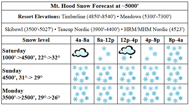
Saturday kicks off cloudy on the slopes. A little snow moves in late morning, and snowfall picks up overnight. The snow level will be around 500-1000′ early, 3500′ this afternoon, and 4000-4500′ overnight. It’s worth mentioning that temps may briefly warm above freezing this afternoon which could result in a brief switch to mist/light drizzle prior to a switch back to snow; temps at 5000′ start in the low 20s, rise to 32-34F, and drop back to 30-32F overnight. Just a trace of precip is forecast prior to 4pm. Overnight, 0.3” water equivalent (WE) is forecast for 2-3” dense new snow. Wind: WSW 10-15 this morning, SW 15-25 this afternoon, and SW 30-40 overnight.
Snow continues all day Sunday and becomes quite intense in the evening. The snow level will be around 4000′-4500′ all day and will fall to 3500′ overnight. About 0.5” WE falls during the day for 4-5” dense new snow. Overnight, around 1.0” WE is forecast for 8-10” additional dense new snow. Wind will be SW 25-35 most of the day with W 25-30 overnight. Temps hold in the 29-32F range all day at 5000′. Consider bringing your “Meadows Performance Outerwear”, aka a garbage bag, to stay dry.
Heavy snow continues all day Monday. The snow level will be 3500′ all day and will fall to 2500′ overnight. Temps will be in the 28-31F range early and will slowly fall to 27-29F in the evening. About 1.0” WE is forecast during the day for 9-11” new snow. Overnight, just 0.2” WE for a couple inches more. Wind will be W 25-30mph all day and W 15mph overnight, which could give us some orographic assistance for 10-20% additional snow over what I just said.
Dry, sunny weather is forecast for Tuesday with temps right around freezing. More snow arrives on Wednesday. Thursday looks dry. Friday may bring some light snow. That’s followed by warming temps and above-freezing weather next weekend. It’s likely a warm atmospheric river will aim at the west coast next weekend, but it’s not yet clear just where it will land. So, we’ll keep a close eye on that. Between now and then: lots of awesome riding!
Liking this forecast?
Was that helpful? I knew it was! Guess what? All of this crucial work – from your personal wind and snow reports to the invaluable TATAS updates – is made possible by my relentless efforts. Maintaining this labor of love isn’t easy. Each daily forecast takes hours. Website hosting, weather model access, and back-end admin work takes time and money. That’s where you come in.
YOUR CONTRIBUTION MAKES A DIFFERENCE
- SUPPORT ACCURATE, HYPER-LOCAL WEATHER FORECASTING
- ENABLE ACCESS FOR ALL, EVEN THOSE WITH LESS MEANS
- SUPPORT A COOL HUMAN WHO WORKS HARD SO YOU CAN PLAY
Take a moment to click one of the buttons below. Donate $19.99 or more (how much does this forecast enhance your life?) and get the email in your inbox. Whether it’s a renewing subscription (auto-renew) or a one-time donation, every contribution makes a real difference. Help me keep this labor of love alive, so we can all continue playing, commuting, and living in the Gorge with peace of mind and the best weather forecasts possible. Thank you!


Hood River, Oregon 97031


GORGE WIND FORECAST

Hi friends! Not much happens in wind land for the next few days. Easterlies (probably) pick up on Tuesday afternoon and Wednesday, but sub-freezing temps are possible on Wednesday along with the easterlies. For Saturday, things start light/variable. Easterlies slowly build. By mid-afternoon, we’ll have 25-30mph at Iwash (Rooster) Rock with 15-20mph near Stevenson. River flow over the last 24 hours was 93-146kcfs, river temp is 37.76F, and high temp forecast is 40F with afternoon drizzle.
Sunday starts with E 10-15mph at Stevenson and E 15mph at Iwash. Iwash turns around and picks up to 10-15mph out of the west. Stevenson holds with light easterlies. High temp: 42F and rainy. Monday starts calm. Westerlies pick up to 15-18mph in the afternoon from Avery to Rufus with 11-14mph from Stevenson to Doug’s. High temp: 46F. Tuesday starts calm. Easterlies ramp up in the afternoon. ON Wednesday, an offshore low combines with a surge of cold air on the east side for much stronger easterlies and sub-freezing (probably) temps. Stay warm and safe out there!
BARE BONES HOOD RIVER WEATHER FORECAST
Cloudy this morning with a little drizzle and partly to mostly cloudy later. Temps start in the mid 30s and rise to 40 or so. Light easterlies. 15% chance of rainbows. Sunday will be rainy. Temps start just above freezing and rise to the low 40s. Light easterlies. 2% chance of rainbows. Monday will be rainy then showery. Temps start in the mid 30s and rise to the mid 40s. Calm wind early. Light to moderate westerlies later. 99% chance of rainbows.
TEMIRA’S AWESOME TRAVEL ADIVSORY SERVICE
HYPERLOCAL WEATHER FORECAST FOR THE COLUMBIA GORGE

Good morning, neighbors! Nice warm-up we had yesterday, eh? While expected, it sure does make the forecast for the next couple of days more difficult. Not much happens today, but precip picks up overnight and really gets going tomorrow all the way through Monday. Depending on daytime heating and cloud cover and what the east wind can manage, this could get messy in some places. Next chance for widespread messiness is Wednesday, when snow is likely at all elevations. Following that: warmer weather next weekend into next week.
GLENWOOD AND THE TATAS EOOTD
But first, Glenwood: 26F this morning with a dewpoint of 21F. Good. Very good. Now, the TATAS Executive Order Of The Day: everyone on DACA gets citizenship. I mean, duh. Signed in green, white and red.
SATURDAY
Most places in the Gorge are running between 27F (up high) and 34F (west) to start Saturday. Looking at the Columbia Basin, where modified arctic air still has hold, we see temps in the teens. Why do we care? Because we really want the east wind to drag some of that back in for fun times. Sadly, we won’t have much east wind today: nearly calm wind this morning picks up to E 25-30 at Cock Rock this afternoon. Other weather news: expect it to be cloudy and mostly dry with a brief band of light snain/snow (up high) or rain (down low) late morning to early afternoon as far east as Hood River. Precip total: a trace, just a trace. The next system arrives late afternoon with moderate rain to Lyle and light rain to Celilo to start. Rain then pushes all the way to Idaho this evening with heavy rain in the western Gorge and east of the Tri-Cities, which I’m not even sure why I’m talking about because it’s not Gorge. Anyway, with temps at 5000′ right around 32F, we’re counting on nighttime cooling and evaporative cooling to get anything other than rain out of this. I’m going with wet, sloppy snow everywhere late tonight with periods of rain possible along I-84. With moderate to heavy precip forecast from Hood River westward and east wind overnight, accumulating slush is possible on I-84. How much? Trace to 2”, depending on where you are. Highest totals in Parkdale, Snowden, Underwood, Mill A, York Hill, and other areas east of Cascade Locks.
SUNDAY
Sunday looks quite wet all the way east to Idaho. Models suggest we’ll have wet snow early all the way down to the river level. Snow totals before a switch to rain: trace to 3”. Some areas, especially those to the east and south (SW/Sherm, notably), could have freezing rain. Daytime heating takes the snow level up to 3500-4000′ in the afternoon and leaves things slushy. Wind will be light easterly all day east of Cascade Locks and light westerly west of Bonneville Dam. Temps: 33F along the river in the morning and upper 30s (east) and low 40s (west) in the afternoon. Pouring rain continues overnight with major snow accumulation above 3000-3500′.
MONDAY & TUESDAY
Models insist that we’ll just have rain on Monday at all Gorge locations. Mountains: lots of snow. Your morning commute will be very, very wet as pouring rain continues through mid-morning west of Hood River. Intermittent showers continues all the way east to The Dalles into the evening. Temps will warm up nicely as the wind turns westerly in the afternoon; expect highs in the mid 40s. Attending the 50501 demonstration at 1pm in Hood River at the bottom of the stairs? Make sure you have rain gear and a sign that can withstand precipitation. Tuesday: dry and partly cloudy with increasing easterlies.
WEDNESDAY AND BEYOND
Ensembles gathered together last night and decided to drag in a shot of cold air for Wednesday. That combines with precip for a snowy day. That’s several days out, but as of right now, things look good for some sort of wintry precip. Thursday: probably dry. Friday: just a little drizzle. Weekend: warmer, but it’s unclear yet if it’ll be warm and wet or warm and merely humid. That’s all for now. I hope that made sense, because I’m really, really tired this morning. Safe travels. -TATAS
HEY! DON’T STOP READING! Is this community-focused forecast helpful to you? It sure is! It takes me a couple hours a day to write. Please join your friends and neighbors in contributing to keep it going. Venmo: @thegorgeismygym PayPal: twomirrors@gmail.com USPS: Temira / PO Box 841 / Hood River, Oregon 97031 You can test out the forecast subscription for a few days for free by clicking this link: https://subscribepage.io/YhevGc
