

MT HOOD WEATHER FORECAST
Hey skiers and snowboarders! Mt Hood weather is shaping up for one last day of glorious spring conditions is on tap before we tumble right back into winter. If you’ve been around here a while, you know that March can be the best month of the year on Mt. Hood. If the extended models are correctly, it’s certainly shaping up to be a snowy one. Heading up today? Expect a mix of frozen granular and hardpack on the groom with corn snow and sticky snow showing up pretty quickly thanks to warming. Wax for it! Couple of things: tomorrow is Pride Day at Meadows. Next: starting Monday, Meadows Value Passes work all the time.
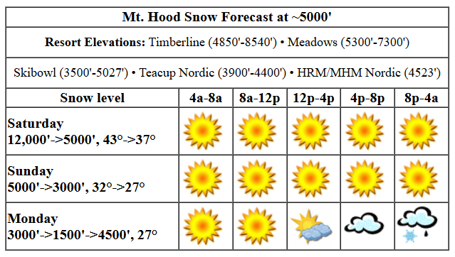
Saturday will be sunny all day. In yesterday’s forecast, we were expecting a super-warm day, but the temp forecast has backed off. The free air freezing level (FAF) today drops from 12,000′ in the morning to 8000′ this afternoon and 5000′ overnight. Temps start in the mid 40s, fall into the upper 30s this afternoon, and drop to 31-32F overnight. A wee bit of mixed precip, just 0.05”, is forecast overnight. Wind will be SW 5-10 all day and W 10-15 after midnight.
Sunday brings snow all day, although a little mixed precip is possible prior to daybreak. The snow level will be 5000′ in the morning, and will bounce around near 3000′ for the rest of the day. About 0.4” water equivalent (WE) is forecast during the day for 3-4” new snow. In the evening, before the sky clears, another 0.1” WE is forecast for another inch of new. Wind will be W 10-15 in the morning, SW 20-25 in the afternoon, and WNW 25-30 overnight.
Orographic snow flurries are possible Monday, but models do call for sun above the clouds. The snow level will be 3000′ in the morning, 1500′ in the afternoon, and 4500′ overnight. An inch or two of snow is possible, but I think it’s more likely we’ll just see a trace along with intermittent sun. Wind: WNW 25-30 all day and SSW 10 overnight.
extended forecast
Clear sky Tuesday morning gives way to light snow overnight with the snow level around 3000′. A cloudy and cool Wednesday gives way to dry weather Thursday and Friday and probably next Saturday. There’s too much uncertainty for the second half of next weekend to make a call yet. Beyond that, models are pretty sure we’ll have an extended period of cool, wet weather with snow pilling up on the slopes. As much as I’m enjoying this warmth, I’ll cheer for that – a deeper snowpack is good for shredding, and it’s also good for forests and farmers. Have a great day on the snow, everyone!
Liking this forecast?
Was that helpful? I knew it was! Guess what? All of this crucial work – from your personal wind and snow reports to the invaluable TATAS updates – is made possible by my relentless efforts. Maintaining this labor of love isn’t easy. Each daily forecast takes hours. Website hosting, weather model access, and back-end admin work takes time and money. That’s where you come in.
YOUR CONTRIBUTION MAKES A DIFFERENCE
- SUPPORT ACCURATE, HYPER-LOCAL WEATHER FORECASTING
- ENABLE ACCESS FOR ALL, EVEN THOSE WITH LESS MEANS
- SUPPORT A COOL HUMAN WHO WORKS HARD SO YOU CAN PLAY
Take a moment to click one of the buttons below. Donate $19.99 or more (how much does this forecast enhance your life?) and get the email in your inbox. Whether it’s a renewing subscription (auto-renew) or a one-time donation, every contribution makes a real difference. Help me keep this labor of love alive, so we can all continue playing, commuting, and living in the Gorge with peace of mind and the best weather forecasts possible. Thank you!


Hood River, Oregon 97031


GORGE WIND FORECAST

Hi friends! Light easterlies are in the cards today (it’s Saturday), and then we’ll have a couple days of westerlies followed by lighter wind. Models are still shifting around on wind speed and location for Sunday and Monday, but Monday does look like the stronger, less wet day. Today starts with pressures of 29.92/30.01 for 0.09 offshore. We’ll have 25mph at Iwash to start. Stevenson builds to 20-25mph around sunrise. By late morning, the wind will already be dropping. Early afternoon looks like E 10mph at Stevenson and light W at Iwash. By mid-morning, we’ll see light west wind, 10mph or less, all through the Gorge. River flow over the last 24 hours was 99-171kcfs, river temp is 38.84F, and high temp forecast is 60F and sunny.
Sunday sees a low slip onshore around Florence with high pressure behind it. This turns the wind onshore. Unfortunately, it now looks like it’ll be rainy west of The Dalles pretty much all day. Models start the day with 11-14mph from Stevenson to Rufus. As the low dissipates and that offshore high pressure takes over, Lyle to Arlington rises to 23-26 with 13-16 at Stevenson. The wind fills in all the way to Boardman mid afternoon. It’s worth mentioning that the offshore high pressure will be pretty strong – 1028mb – meaning the wind could beat expectations. Hopefully it does; sensor readings of 23-26 out east are right on the edge of enough. High temp: 51F and mostly cloudy.
Models have a fair bit of uncertainty on Monday, but generally speaking, they’re predicting stronger wind than on Sunday. High pressure will build inland during the day. This will shift the wind east. So, for now, let’s call it 22-25 to start form Viento to Mosier dropping to 14-17 in the afternoon. Out east: 21-24 to start with 26-29 in the afternoon. I’ll try and be more precise in tomorrow’s forecast, okay? High temp: 51F with mostly cloudy sky in the morning and partly cloudy sky later.
BARE BONES HOOD RIVER WEATHER FORECAST
Clear sky today with high clouds late. Temps start in the mid 30s and rise to 60 or so. Light easterlies this morning. Calm wind later. No rainbows. Sunday will be cloudy with drizzle all day. Temps start in the mid 40s and rise to the low 50s. Moderate westerlies. 99% chance of rainbows. Monday will be mostly cloudy then partly cloudy. Temps start in the low 40s and rise to the low 50s. Moderate westerlies. 11% chance of rainbows.
TEMIRA’S AWESOME TRAVEL ADVISORY SERVICE
HYPERLOCAL WEATHER FORECAST FOR THE COLUMBIA GORGE
THE DALLES, HOOD RIVER, WHITE SALMON, TROUT LAKE, STEVENSON, CASCADE LOCKS, PARKDALE, ODELL, HUSUM, BZ, MILL A, WILLARD, GOLDENDALE, RUFUS, ARLINGTON, boardman

Good morning, neighbors! One more glorious day is on tap today. We’re back to rain and clouds after this. For those of you whose gardens are snow-free, now’s a great time to get out there and plant a few cool-weather seeds. Just be careful about digging – you don’t want to ruin your soil by messing with it when it’s too wet.
glenwood and the tatas EOOTD
Let’s start by wishing our friends in Glenwood a good morning. It’s 27 degrees there with a dewpoint of 22. Next, the TATAS Executive Order of The Day: for-profit companies can’t have federal subsidies unless they’re committed to humane employment. No forced overtime; full benefits for all employees and contractors; compensation transparency; commitment to a welcome environment that promotes diversity, equity (including pay equity across genders), and inclusion of folks with different backgrounds.
today
On to our weather. I’m so excited for the sun to come up, because it’s going to be glorious today: 60 degrees, light wind, and blue sky. It’s a great day to protest authoritarianism: 12pm-1pm at the bottom of the Hood River Stairs. Make a few laps on the stairs if you’re feeling feisty. It’s also a great day to play in the garden. Valuable Advice for Gardeners Inhabiting Neighboring Areas: if your soil is above 40 degrees, you can plant radishes, lettuce, mustard, peas (germinate inside for best results), bok choy, spinach (maybe), kale, and other cool-weather greens.
sunday
We’ll lose the sun (mostly) on Sunday. Drizzle sticks around through early afternoon west of The Dalles. South Wasco, Sherman, and areas east of The Dalles will be wet from mid-morning on into early evening. It won’t be super wet – most places will have under a quarter inch of rain, but it will be persistent. Along with the rain, we’ll have west wind at 10-15mph west of Lyle and 25mph from Lyle eastward. High temps reach the low 50s, and mostly cloudy sky sticks around most of the day.
monday
Most of us will be dry on Monday. Exception: areas east of Rufus will see drizzle until mid-morning. Cloud coverage will be extensive early, but we’ll all have partly cloudy sky in the afternoon. It’ll also be breezy: 25mph from Viento to Rufus to start with 15mph west of Lyle in the afternoon and 25-30mph east of Lyle all the way to Boardman. Temps top out in the low 50s.
tuesday and beyond
Tuesday and Wednesday look drizzly with relatively light wind. The latter half of next week and the start of next weekend look dry. Models are still 50/50 on heavier rain or pineapple potential Sunday. After that, models are pretty consistent in calling for cooler, wet weather in the lowlands and lots of snow for the mountains. Within the range of possible outcomes is snow down to 1500′ or so, but it’s really way too far out for any precision forecasting. Given all the wet weather in the forecast, definitely make the most of today’s sun and warmth. Safe travels. -TATAS
HEY! DON’T STOP READING! Is this community-focused forecast helpful to you? It sure is! It takes me a couple hours a day to write. Please join your friends and neighbors in contributing to keep it going. Venmo: @thegorgeismygym PayPal: twomirrors@gmail.com USPS: Temira / PO Box 841 / Hood River, Oregon 97031 You can test out the forecast subscription for a few days for free by clicking this link: https://subscribepage.io/YhevGc
