

MT HOOD SNOW FORECAST

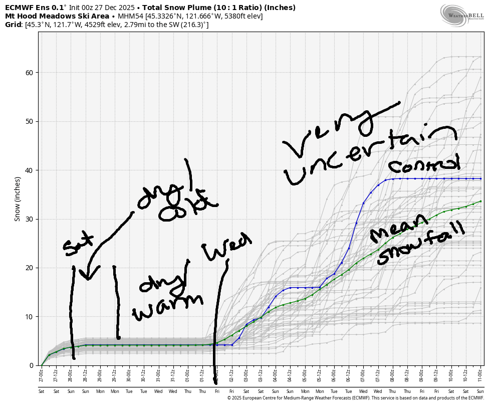
Hey skiers and snowboarders! The last 48 hours brought about a foot of much-needed new snow to Mt. Hood. Last night also brought blasting wind, which is good if you like your leeward slopes filled with powder and bad if you prefer your trees standing upright – there were definitely some that came down last night. While the pre-dawn wind is strong enough to shut all the lifts down, models insist it will back off some today and allow lifts to run. Beyond today: no new snow for a while, and also no significant weather impacts.
Short term Mt Hood snow forecast
Saturday started off very windy – Magic Mile sensor reported a gusty to 91mph overnight, and top of Mt Hood Express sensor reported a period of 50-70mph west wind, enough to shut down all the lifts. Lean into the forecast today: The snow level starts around 1500′, falls to 1000′ this afternoon, and the free air freezing level will be 0′ under clear sky overnight. We’re only expecting an inch or so of new snow prior to the snow ending mid-morning. Wind forecast: NW 30-40mph early (that speed on the models almost always shuts down Meadows), NW 20 midday, NW 15-20 this evening, and NNW 10 overnight. Temps hold in the low 20s at 5000′, and snow surface will be a mixed of powder, wind-packed powder, and wind-scoured granular areas.
Sunday starts partly cloudy and ends partly high overcast. The free air freezing level (FAF) will be 0′ in the morning, 5000′ in the afternoon, and 6000′ after midnight. Temps will be in the low 20s early and right around 32F in the afternoon. Wind: NNW 10 in the morning, east 10 in the afternoon, and light/variable overnight. Snow surface: packed powder, hardpack, and scoured areas.
Extended Mt Hood Snow Forecast
Temps start warming on Monday: the FAF starts around 6000′ and ends around 10,000′. Temps at 5000′ rise to 40F or so in the afternoon. Sky will have high clouds. Wind: light/variable. Tuesday looks warm, partly high overcast, and dry with light/variable wind and max temps between 40F and 50F. Wednesday: partly high overcast, warm, and sunny with light wind.
Precipitation is likely to return on Thursday, possibly as rain, but quickly switching over to snow by Friday. Beyond that, there’s a ton of uncertainty in the models, but at least some hope that we’ll pick up more snow next weekend. Have a great day on the slopes today. See you out there!
Was that helpful? I knew it was! Guess what? All of this crucial work – from your personal wind and snow reports to the invaluable TATAS updates – is made possible by my relentless efforts. Maintaining this labor of love isn’t easy. Each daily forecast takes hours. Website hosting, weather model access, and back-end admin work takes time and money. That’s where you come in.
YOUR CONTRIBUTION MAKES A DIFFERENCE
- SUPPORT ACCURATE, HYPER-LOCAL WEATHER FORECASTING
- ENABLE ACCESS FOR ALL, EVEN THOSE WITH LESS MEANS
- SUPPORT A COOL HUMAN WHO WORKS HARD SO YOU CAN PLAY
Take a moment to click one of the buttons below. Donate $19.99 or more (how much does this forecast enhance your life?) and get the email in your inbox. Whether it’s a renewing subscription (auto-renew) or a one-time donation, every contribution makes a real difference. Help me keep this labor of love alive, so we can all continue playing, commuting, and living in the Gorge with peace of mind and the best weather forecasts possible. Thank you!


Hood River, Oregon 97031


GORGE WIND FORECAST
If you’re still seeing yesterday’s and it’s after 9am, try opening this in an incognito window
SHORT-TERM gorge wind forecast
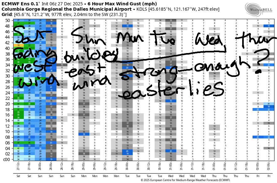
Hi friends! As expected, the strongest west wind arrived overnight – for several hours, Viento was reading mid-30s. As I was writing this forecast, it was down to the upper 20s with teens at the Hatch. Still… we might get just enough this morning to get you on the water. Starting Sunday, we move into a classic east wind pattern – high pressure inland, cold temps in the desert, sunshine on the west side. That persists for several days.
Saturday started with pressures of 30.14/30.02/30.00 for 0.12 PDX-DLS. Hence the wind! We should see a few hours of 18-21mph west wind from Stevenson (or Viento) to Doug’s this morning with 11-14mph from Avery to Rufus. Afternoon wind fades to 11-14mph between Stevenson and Avery with lighter wind to the east. River flow over the last 24 hours was 167-205kcfs, river temp is 46.8F, and high temp forecast is 42F with decreasing clouds. Watch for debris in the water due to recent heavy rains.
RIVER FLOW FOR SITES BETWEEN AVERY (EAST OF THE DALLES) AND RUFUS: CLICK HERE FOR JOHN DAY DAM FLOW.
RIVER FLOW FOR SITES BETWEEN STEVENSON AND DOUG’S BEACH (WEST OF THE DALLES): CLICK HERE FOR THE DALLES DAM FLOW

LONGER-TERM gorge wind forecast
Sunday starts dead calm. Offshore (east) wind builds during the day. By afternoon, Stevenson will be 25mph, Viento 15-20mph, and Iwash (Rooster) Rock at 25-30mph. High temp: 41F with partly cloudy sky.
As of this morning, models hold the east wind pattern and 40 degree high temps through Wednesday. Iwash should see 40mph or so each day, and Stevenson should be around 30mph. After Wednesday, model uncertainty rises, so I’ll leave it there for now. As of this morning, there’s no sign of west wind in the next couple of weeks after today, so ya better get it now if you want it!
BARE BONES HOOD RIVER WEATHER FORECAST
Showers this morning. Dry from mid-morning on. Temps start in the upper 30s and rise to the low 40s. Moderate westerlies. 98% chance of rainbows. Sunday will be partly cloudy. Temps start in the upper 20s and rise to the low 40s. Calm wind early. Light easterlies later. No rainbows. Monday will be partly Nothing then partly high overcast. Temps start in the upper 20s and rise to 40. Light easterlies. No rainbows.
TEMIRA’S AWESOME TRAVEL ADVISORY SERVICE
HYPERLOCAL WEATHER FORECAST FOR THE COLUMBIA GORGE
THE DALLES, HOOD RIVER, WHITE SALMON, TROUT LAKE, STEVENSON, CASCADE LOCKS, PARKDALE, ODELL, HUSUM, BZ, MILL A, WILLARD, GOLDENDALE, RUFUS, ARLINGTON, boardman
Good morning, neighbors! It’s a chilly, drizzly morning here in the ol’ Columbia River Gorge, and it’s entirely possible you’ll find a bit of snow and slush if you’re driving in our highest elevations. So far, roads appear clear of ¡CE, but it’s still quite early, and not much inspection has been done. Looking at the weather forecast beyond today, there’s not much to see. Our biggest concern is the potential for icy roads throughout the Gorge tonight and for the remainder of the week as high pressure builds and radiational cooling takes hold overnight.
Glenwood this morning
Speaking of overnight, Glenwood dipped to 34 last night. This being “National Fruitcake Day”, everyone in Glenwood was up early making huckleberry fruitcakes. That’s also what folks call the Prime Minister of Glenwood (not a real position) – “Huckleberry Fruitcake”. In the native dialect of Glenwood, that’s a loving compliment.
Today’s Gorge weather forecast
Elsewhere in the Gorge, temps were generally in the mid 30s to start the day. We’re expecting a chilly drizzle until 9am or so west of Hood River with dry weather everywhere for the rest of the day. We’ll even see sunshine filtered through a few high clouds. Afternoon temps rise to the low 40s (west and east) with mid 40s for The Dalles Snow level: 1500′ and falling as -6C air moves in aloft. Today’s wind will be W 20mph west of The Dalles this morning and W 10-15mph from Stevenson to Rufus this afternoon. Up on the passes: blasting westerlies this morning with less wind later, but you’ll still have wintry driving conditions.
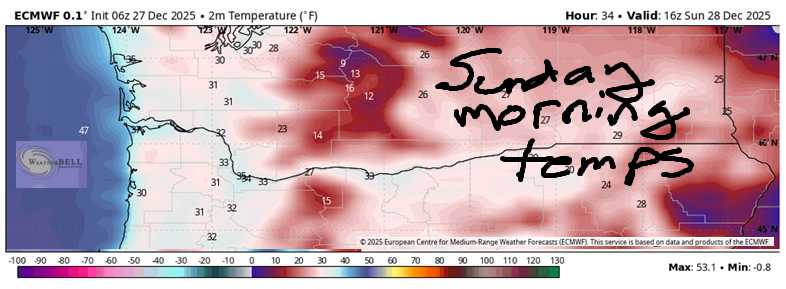
Sunday’s Gorge weather forecast
Overnight into Sunday, temps fall below below freezing as the dewpoint dips into the teens away from the Nch’i Wana (Columbia River) and the upper 20s near it. This (probably) results in a partial Nothing near the river and freezing fog for some folks. For the rest of us: black ice is likely to start the day, and it’s possible all day long in shady areas. Be careful out there. By afternoon, temps warm to 40F or so (mid 30s way out east). Calm wind starts the day. East wind at 25-30mph in the usual spots (Stevenson, Iwash Rock) finishes up.
Extended Gorge weather forecast
Temps fall below freezing again on Monday morning. We’ll have a few high clouds, which might stop the Nothing, but won’t stop the icy roads. Expect partly high overcast sky all day with east wind at 40mph (Iwash) and 30mph (Stevenson). This exact weather repeats on Tuesday and Wednesday.
We’re expecting some sort of weak weather system on Thursday. If the timing were to be just right, we might get some “interesting” precipitation from it. Predicting that timing this far in advance is impossible. Ditto for the longer-range forecast. It is worth noting that models are NOT calling for any sort of extended or intense cold spell in the next couple of weeks. Hmph. How boring. Safe travels. -TATAS
HEY! DON’T STOP READING! Is this community-focused forecast helpful to you? It sure is! It takes me a couple hours a day to write. Please join your friends and neighbors in contributing to keep it going. Venmo: @thegorgeismygym PayPal: twomirrors@gmail.com USPS: Temira / PO Box 841 / Hood River, Oregon 97031 You can test out the forecast subscription for a few days for free by signing up below. Easy! Do it!
JONES BEACH, SAUVIE ISLAND, & COAST FORECAST
ON WINTER VACATION UNLESS DESPERATELY NEEDED.
