

MT HOOD SNOW FORECAST

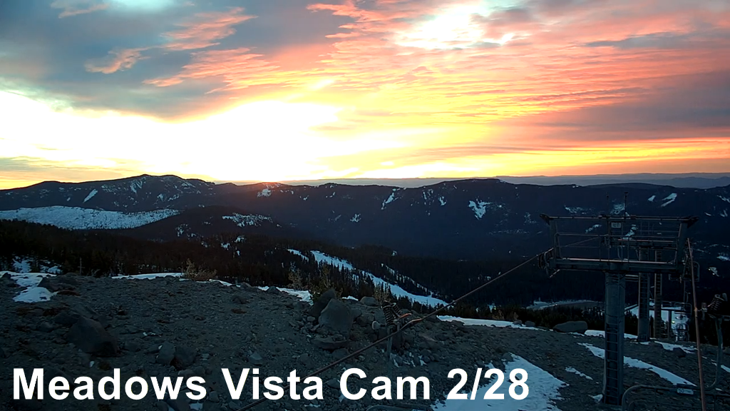
Hey skiers and snowboarders! I’m a bit distracted as I’m writing this because I’m watching the spectacular sunrise from both my window and on the Meadows Vista cam. Red skies at morning, sailors take warning… except that this system isn’t going to come far enough north to do anything more than add clouds to the mix today.
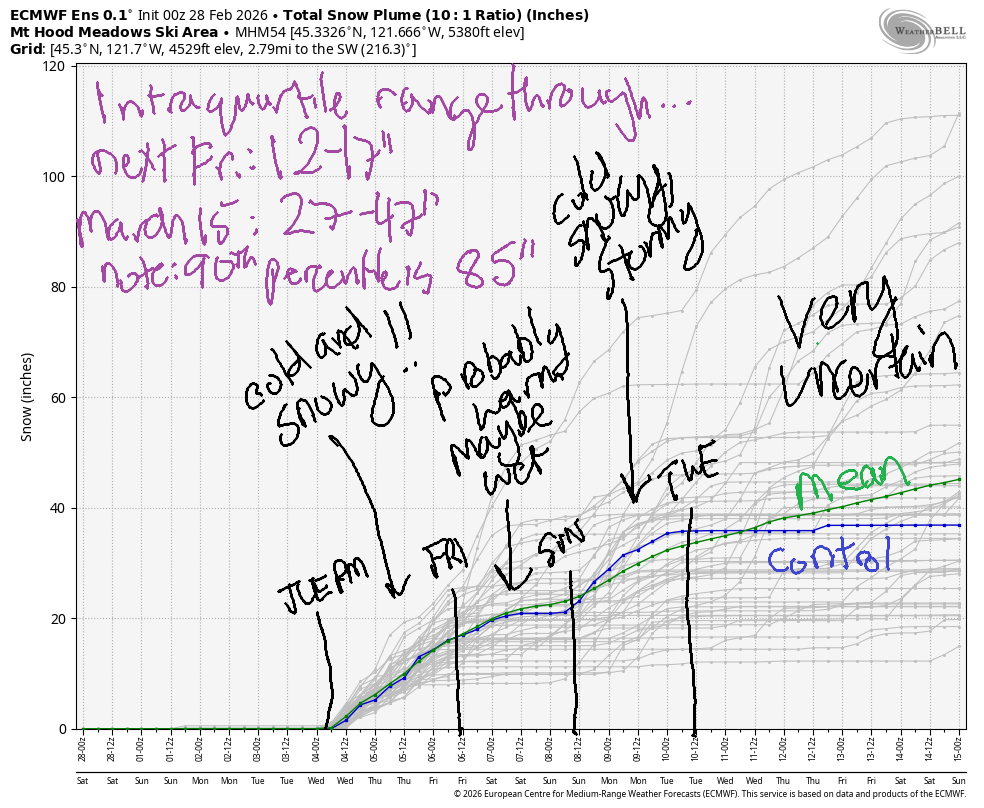
We’ll stick with dry weather until Tuesday afternoon when honest-to-goodness snow is in the forecast. The intraquartile range through next Friday is 12-17”, and the range through 3/15 is 27-47”. It’s worth noting that the 90th percentile is 85” – that huge range is due to both fluctuations in temp and the potential for snow to exceed expectations thanks to W/NW wind.
Short term Mt Hood snow forecast
Saturday will be a dry and warm day on the slopes. Clouds stick around most of the day and filter the sun. The free air freezing level (FAF) will be 9000′ in the morning, 9500′ in the afternoon, and 8000′ overnight. Temps max out in the mid 40s at 5000′ (they started at 44F at the base of Meadows). Wind will be variable to 10mph all day long. Worth mentioning: Meadows opened Heather yesterday, and Teacup was super fun. Snow conditions are hardpack up high and granular down low with spring conditions expected in the afternoon due to the warmth.
Sunday will be cloudy. We can’t rule out the tiniest trace of rain in the afternoon, but it’s pretty unlikely. The FAF will be 8000′ in the morning, 7500′ in the afternoon, and 7000′ after midnight. Temps max out in the low 40s. Wind: light and variable all day becoming NE 10 overnight.
Extended Mt Hood Snow Forecast
Monday will be sunny. The free air freezing level bounces around between 7000′ and 8000′ with temps at 5000′ maxing out in the low-mid 40s. Snow: spring skiing after a frozen granular start. Wind: NE 20mph all day becoming S 15-25 overnight.
Transitional weather is forecast on Tuesday as a system approaches from the northwest. Clear sky in the morning gives way to snow in the evening with the free zing level at 7000′ in the morning and 4000′ when the system arrives. A few inches of medium-density snow are forecast overnight. Wind builds from S 15-25 in the morning to W 25 in the afternoon and WSW 40 overnight. Stormier weather (W 40mph, snow level 3000′) is forecast on Wednesday with up to a foot (or more) of new snow.
Snow continues into Friday, after which temps seem likely to warm for 24-26 hours. Another cold, snowy system is in the cards late next weekend or early next week, assuming the current forecast holds. All-in-all, considering how things have gone so far this season, this looks like a decent stretch of weather! Fingers crossed for the 90th percentile of snowfall. Let’s do some catching up to “normal”!!!
Was that helpful? I knew it was! Guess what? All of this crucial work – from your personal wind and snow reports to the invaluable TATAS updates – is made possible by my relentless efforts. Maintaining this labor of love isn’t easy. Each daily forecast takes hours. Website hosting, weather model access, and back-end admin work takes time and money. That’s where you come in.
YOUR CONTRIBUTION MAKES A DIFFERENCE
- SUPPORT ACCURATE, HYPER-LOCAL WEATHER FORECASTING
- ENABLE ACCESS FOR ALL, EVEN THOSE WITH LESS MEANS
- SUPPORT A COOL HUMAN WHO WORKS HARD SO YOU CAN PLAY
Take a moment to click one of the buttons below. Donate $19.99 or more (how much does this forecast enhance your life?) and get the email in your inbox. Whether it’s a renewing subscription (auto-renew) or a one-time donation, every contribution makes a real difference. Help me keep this labor of love alive, so we can all continue playing, commuting, and living in the Gorge with peace of mind and the best weather forecasts possible. Thank you!


Hood River, Oregon 97031


GORGE WIND FORECAST
If you’re still seeing yesterday’s and it’s after 9am, try opening this in an incognito window
SHORT-TERM gorge wind forecast
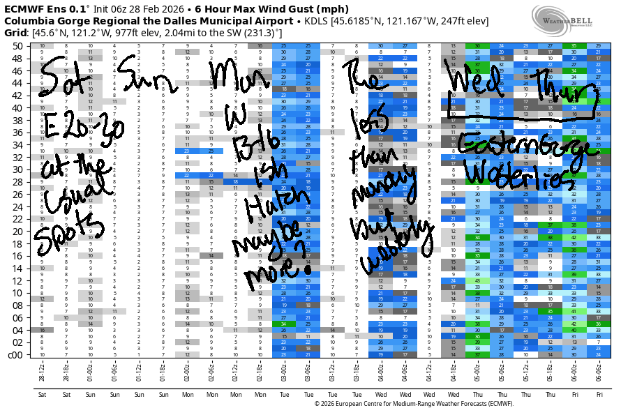
Hi friends! It’s Saturday, and easterlies return today and stick around for a couple of days. Starting Monday, we’ll generally be in a west wind pattern for a while. We’ll talk about that in the long-range discussion…
Saturday started off with light west gradients, but models insist we’re looking at an east wind day thanks to a heat low on the west side and cool air pooled in the desert. Easterlies build to 30mph at both Iwash/Rooster and Stevenson mid-morning. They’ll drop in the afternoon and finish the day at 20-25mph at Iwash and 15-20mph at Stevenson. River flow over the last 24 hours was 165-197kcfs, river temp is 41.5F, and high temp forecast is 54F. So, so close to 100F combined!
RIVER FLOW FOR SITES BETWEEN AVERY (EAST OF THE DALLES) AND RUFUS: CLICK HERE FOR JOHN DAY DAM FLOW.
RIVER FLOW FOR SITES BETWEEN STEVENSON AND DOUG’S BEACH (WEST OF THE DALLES): CLICK HERE FOR THE DALLES DAM FLOW

LONGER-TERM gorge wind forecast
Sunday starts with E 30mph at Iwash and E 15mph at Stevenson. They level out at 20-25mph mid-morning before dropping to 15-20mph in the afternoon. High temp: 55F with mostly cloudy sky. Monday starts calm, turns westerly at 13-16mph (perhaps more) from Stevenson to Hood River mid-morning, and drops to 10mph or less in the afternoon. High temp: 59F. Add that to the water temp, and you have 100 degrees!
While the details aren’t clear on Tuesday and Wednesday, we do have a cold front scheduled to arrive late in the day Tuesday. Depending on timing, we could end up with afternoon westerlies ahead of the rain. Eastern Gorge west wind is likely on Wednesday and Thursday. Looking deeper into the future, both the GFS and ECMWF have a much stronger, NNW-oriented cold front sometime next Saturday-Tuesday. Models are already insisting on a big eastern Gorge day. We’ll keep a very close eye on this – this particular setup is what we look for when we’re seeking a play day at Rufus or areas farther east. That doesn’t rule out the Hatch, btw, but it almost certainly rules in Rufus. We’ll keep a close eye on this for sure! See you on the Nch’i Wana!
BARE BONES HOOD RIVER WEATHER FORECAST
Partly high overcast this morning with more clouds later. Temps start near 30 and rise to the mid 50s. Light easterlies. No rainbows. Sunday will be mostly cloudy. Temps start in the upper 30s and rise to the mid 50s. Light easterlies. No rainbows. Monday will be partly cloudy then sunny. Temps start in the upper 30s and rise to the upper 50s. Calm wind early. Moderate westerlies later. No rainbows.
TEMIRA’S AWESOME TRAVEL ADVISORY SERVICE
HYPERLOCAL WEATHER FORECAST FOR THE COLUMBIA GORGE
THE DALLES, HOOD RIVER, WHITE SALMON, TROUT LAKE, STEVENSON, CASCADE LOCKS, PARKDALE, ODELL, HUSUM, BZ, MILL A, WILLARD, GOLDENDALE, RUFUS, ARLINGTON, boardman
Good morning, neighbors! The Winter That Wasn’t continues to not be, but it might be something around March 9th or 10th. Or maybe not. At least there will be some winter up in the mountains in the next couple of weeks! Down here: dry weather with temps 55+ in the lowlands until late Tuesday, after which we’ll see several days of cooler weather with rain west of The Dalles. To the east: windy and dry.
Glenwood this morning
Thanks to a lack of clouds last night, Saturday in Glenwood started at 25 degrees. Hood River Weather website (back up and running finally!!!) says it was 30 degrees in Hood River to start the day. The upper valley was an interesting place this morning with the higher parts of Parkdale at 40F, Middle Mountain at 43F, and the lower parts of Parkdale reading 28F!
Today’s Gorge weather forecast
For the rest of today, we’ll all have a combo of mid and high clouds. A few sprinkles are possible south of Odell and Dufur. Lowland temps max out in the mid 50s, and the freezing level rises to 9500′ this afternoon. Near Stevenson and Iwash (translation: p*nis) Rock, easterlies rise to 30mph midday before decreasing to 20mph this afternoon.
Sunday’s Gorge weather forecast
Overnight, clouds stick around and insulate us from the heat-sucking universe. Most locations start Sunday above freezing, but it really depends on how thick the clouds get. Thicker = warmer. Thicker = better! Sunday temps rise to the mid 50s, and the freezing level hangs out around 7500′. Wind will be 30mph near the large basalt cock early and 15-20mph in the afternoon. Stevenson sees 20-25mph max wind on Sunday.
Extended Gorge weather forecast
Thanks to a switch to NE wind aloft into Monday, we’ll end up with clear sky and (duh) sunshine. After a nearly 40 degrees start in the lowlands, temps rise to SIXTY DEGREES! OH MY GOD! Add in west wind at 10-15mph for a perfect spring day. Meteorological spring starts March 1st. You’ll have to wait until the 21st for calendar spring. A weather system moving in Tuesday results in increasing afternoon clouds, decreasing high temps (55F rather than 60F), and light rain west of The Dalles overnight. Cooler temps are forecast for the rest of the week with periods of rain west of The Dalles.
Looking even deeper into the future, we see the possibility of colder temps combined with precipitation to start the following week. Some ensemble members think it’ll be cold enough for snow at 1000’+, but it’s too soon to know for sure. We’ll keep an eye on it. It would be nice to get some lowland snow, as we’re quickly running out of time for anything but a truly unseasonable snowfall. Safe travels. -TATAS
HEY! DON’T STOP READING! Is this community-focused forecast helpful to you? It sure is! It takes me a couple hours a day to write. Please join your friends and neighbors in contributing to keep it going. Venmo: @thegorgeismygym PayPal: twomirrors@gmail.com USPS: Temira / PO Box 841 / Hood River, Oregon 97031 You can test out the forecast subscription for a few days for free by signing up below. Easy! Do it!
JONES BEACH, SAUVIE ISLAND, & COAST FORECAST
ON WINTER VACATION UNLESS DESPERATELY NEEDED.

Leave a Reply