

MT HOOD SNOW FORECAST

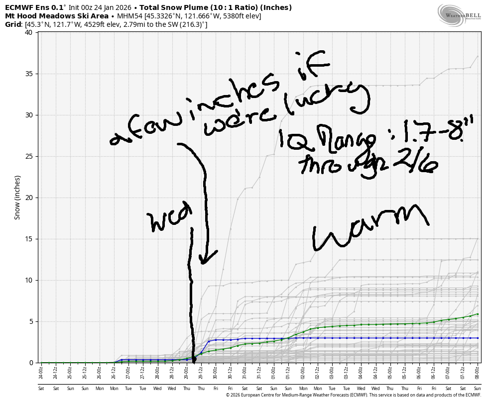
Hey skiers and snowboarders! Eternal Sunshine of the Ski Slopes continues playing on repeat today on Mt. Hood. Clouds filter in on Sunday and linger into Monday morning, but they’re unlikely to bring us any precipitation. Next chance of anything falling out of the sky is next Wednesday (ish), but models are far from agreeing on the details of this. Generally speaking, the weather looks too warm for snow all the way through the first week of February unless something changes dramatically in the models. The intraquartile range for snowfall between now and February 7th is 1.7” to 8.0”. We currently sit at 32% of normal snowpack and are at the 4th percentile. Ouch.
Short term Mt Hood snow forecast
That won’t stop today from being a good day to spend on Mt. Hood. It’s going to be a sunny Saturday! The free air freezing level (FAF) starts at 0′ and rises to 6000′ with temps at 5000′ maxing out in the mid to upper 30’s. Early temps were in the mid to upper 20s up high and 0-14F at the XC zones making it a blue or blue-violet wax day. Once again, conditions for XC will be off the charts good, and remember that skate skiing conditions are almost always epic when alpine conditions are marginal! We’ll see a mix of hardpack and granular for folks on the alpine slopes today with hardpack in the XC zones. Wind today will be E 20mph in the morning and light/variable in the afternoon.
High clouds early Sunday set us up for a beautiful sunrise. By afternoon, clouds thicken. The FAF will be 6000′ all day and will rise to 6500′ overnight. Temps max out in the mid 30s. Wind will be light and variable all day long with W 20-25mph overnight.
Extended Mt Hood Snow Forecast
Clouds Monday morning give way to partly cloudy sky in the afternoon and clear sky overnight. The FAF will be 6500′ in the morning and 5500′ from mid-afternoon on into the night. Temps max out in the mid 30s. Wind will be W or WSW 20-25 all day and SW 10 overnight. Sunshine returns on Tuesday will temps maxing out in the mid 30s at 5000′ and light to moderate S/SW wind.
Models suggest this ridge of high pressure may break down on Wednesday. Those models are all over the place on temps and precipitation amounts that accompany this breakdown. If we get really lucky, we’ll get some snow out of this, but that’s far from guaranteed. Looking at the ECMWF and GFS for the next couple of weeks, we generally have temps at 850mb over 0C, which is not a great sign for building the snowpack. So, set aside your powder dreams and get up to the slopes for some groom, park, and XC!
Was that helpful? I knew it was! Guess what? All of this crucial work – from your personal wind and snow reports to the invaluable TATAS updates – is made possible by my relentless efforts. Maintaining this labor of love isn’t easy. Each daily forecast takes hours. Website hosting, weather model access, and back-end admin work takes time and money. That’s where you come in.
YOUR CONTRIBUTION MAKES A DIFFERENCE
- SUPPORT ACCURATE, HYPER-LOCAL WEATHER FORECASTING
- ENABLE ACCESS FOR ALL, EVEN THOSE WITH LESS MEANS
- SUPPORT A COOL HUMAN WHO WORKS HARD SO YOU CAN PLAY
Take a moment to click one of the buttons below. Donate $19.99 or more (how much does this forecast enhance your life?) and get the email in your inbox. Whether it’s a renewing subscription (auto-renew) or a one-time donation, every contribution makes a real difference. Help me keep this labor of love alive, so we can all continue playing, commuting, and living in the Gorge with peace of mind and the best weather forecasts possible. Thank you!


Hood River, Oregon 97031


GORGE WIND FORECAST
If you’re still seeing yesterday’s and it’s after 9am, try opening this in an incognito window
SHORT-TERM gorge wind forecast
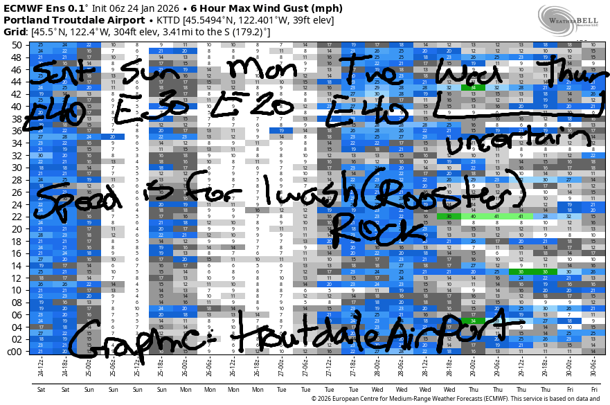
Hi friends! Easterlies continue…. Saturday started with 39mph at Iwash, 18mph at Stevenson, and 14mph at Viento. With east wind spilling over the Cascade crest early, the wind will be lighter than expected given the gradients. Midday sees Stevenson pick up to 25-30 and Viento pick up to 20mph. Afternoon wind holds at those locations and drops to 30-35mph at Iwash. River flow over the last 24 hours was 187-219kcfs, river temp is 41.9F, and high temp forecast is 39F and sunny.
RIVER FLOW FOR SITES BETWEEN AVERY (EAST OF THE DALLES) AND RUFUS: CLICK HERE FOR JOHN DAY DAM FLOW.
RIVER FLOW FOR SITES BETWEEN STEVENSON AND DOUG’S BEACH (WEST OF THE DALLES): CLICK HERE FOR THE DALLES DAM FLOW

LONGER-TERM gorge wind forecast
Sunday brings 40-45mph at Iwash all day and 30ish mph at Stevenson. High temp: 38F with increasing clouds throughout the day. Monday starts with 30-35mph at Iwash and 25mph at Stevenson. The wind drops to 15-20mh at Stevenson in the afternoon and 10-15mph at Iwash. High temp: 44F with clouds in the morning and sun in the afternoon.
Tuesday brings another round of easterlies – as of this morning, it’s looking like 40mph at Iwash and 30mph at Stevenson. Models hint at this weather pattern (maybe) breaking down on Wednesday which would give us light easterlies. No sign of westerlies in the future. Stay warm and safe out there on the river. Dress warmly, have an emergency plan, and keep an eye on your buddies!
BARE BONES HOOD RIVER WEATHER FORECAST
Clear sky today. Temps start in the upper 20s and rise to the upper 30s. Light easterlies. No rainbows. Sunday will be mostly clear then cloudy. Temp start in the mid 20s and rise to the upper 30s. Light easterlies. No rainbows. Monday will be partly cloudy then mostly clear. Temps start in the upper 20s and rise to the mid 40s. Light easterlies. No rainbows.
TEMIRA’S AWESOME TRAVEL ADVISORY SERVICE
HYPERLOCAL WEATHER FORECAST FOR THE COLUMBIA GORGE
THE DALLES, HOOD RIVER, WHITE SALMON, TROUT LAKE, STEVENSON, CASCADE LOCKS, PARKDALE, ODELL, HUSUM, BZ, MILL A, WILLARD, GOLDENDALE, RUFUS, ARLINGTON, boardman

Good morning, neighbors! The Gorge tapped into dry continental air last night, and that’s left many of us cold, dry, and Nothing-free this morning. Make the most of this sunny day! We’ll have clouds tomorrow and parts of Monday, and then the weather (probably) devolves into something more normal for this time of year on Wednesday.
Glenwood this morning
In the meantime… Glenwood FINALLY did its thing this morning – thermometers there are reading 11F to start the day with the dewpoint at 8F. Glenwood wins, and they’re all dancing in the streets after being handed all the cold weather trophies that haven’t already ended up in the hands of USPS on the way to 1600 Pennsylvania Avenue. Other coldl weather news this morning: up at Teacup, overnight temps were 0-10F. Local over-performers last night: Trout Lake at 14F and the Upper Valley with 14-18F. Good job! Minneapolis is under 0F and full of ¡CE, but here, our frosty roads appear to be ¡CE-free this morning, thank the stars!
Today’s Gorge weather forecast
I’m guessing there’s at least some Nothing to the east today – that’s based on temps. We all should end up sunny today thanks to this lower-humidity air. Max temps in the lowlands will be in the upper 30s. Up in the hills, the freezing level rises to 6000′, so only the coldest of cold spots resist the urge to climb above freezing today. East wind continues with 30-40mph at Iwash (release the pedo-files!) Rock and 25-30mph at Stevenson.
Sunday’s Gorge weather forecast
Clouds filter in tonight, but they should be thin enough on Sunday morning for 1) cold temps and 2) a beautiful sunrise on the west side. Out east: partly Nothing is likely in the morning. Morning temps: mid 20s or less. Afternoon temps: upper 30s under cloudy sky. Easterlies: yes. 40-45mph at Iwash (eggplant-shaped thing) Rock and 25-30mph at Stevenson.
Extended Gorge weather forecast
Monday starts partly to mostly cloudy all across he land. By afternoon, we’ll have mostly clear sky. This gives us temps in the upper 20s early and low 40s later. East wind fades from 30-35mph at Iwash Rock in the morning to 10-15mph in the afternoon. Stevenson: 25mph early and 15-20mph later.
Tuesday: boring: 40 degrees, 40mph easterlies, 40% partly high overcast. All things shall be 40 on Tuesday.
If we are very, very lucky, this extended dry spell will end on Wednesday as a system sends moisture our way. Models vary widely on how much precipitation they expect. Given the dry air in place, precipitation is likely to under-perform (like the Rams will hopefully under-perform on Sunday). We’re too far out from this weather event to determine if we’ll see any wintry precipitation from it. Given the marginal temps at the surface and marginal amount of precipitation forecast, major impacts are unlikely. Beyond Wednesday: no signs of weather disasters other than above-normal temps and about zero percent chance of growing the snowpack. Safe travels. -TATAS
HEY! DON’T STOP READING! Is this community-focused forecast helpful to you? It sure is! It takes me a couple hours a day to write. Please join your friends and neighbors in contributing to keep it going. Venmo: @thegorgeismygym PayPal: twomirrors@gmail.com USPS: Temira / PO Box 841 / Hood River, Oregon 97031 You can test out the forecast subscription for a few days for free by signing up below. Easy! Do it!
JONES BEACH, SAUVIE ISLAND, & COAST FORECAST
ON WINTER VACATION UNLESS DESPERATELY NEEDED.
