

MT HOOD SNOW FORECAST

Hey skiers and snowboarders! It’s another snowy and blowy morning on Mt. Hood, but the sun will come out soon, and temps will drop some. After today, we’re looking at another stretch of warm weather until late Tuesday, when it’s possible we could pick up a little snow.
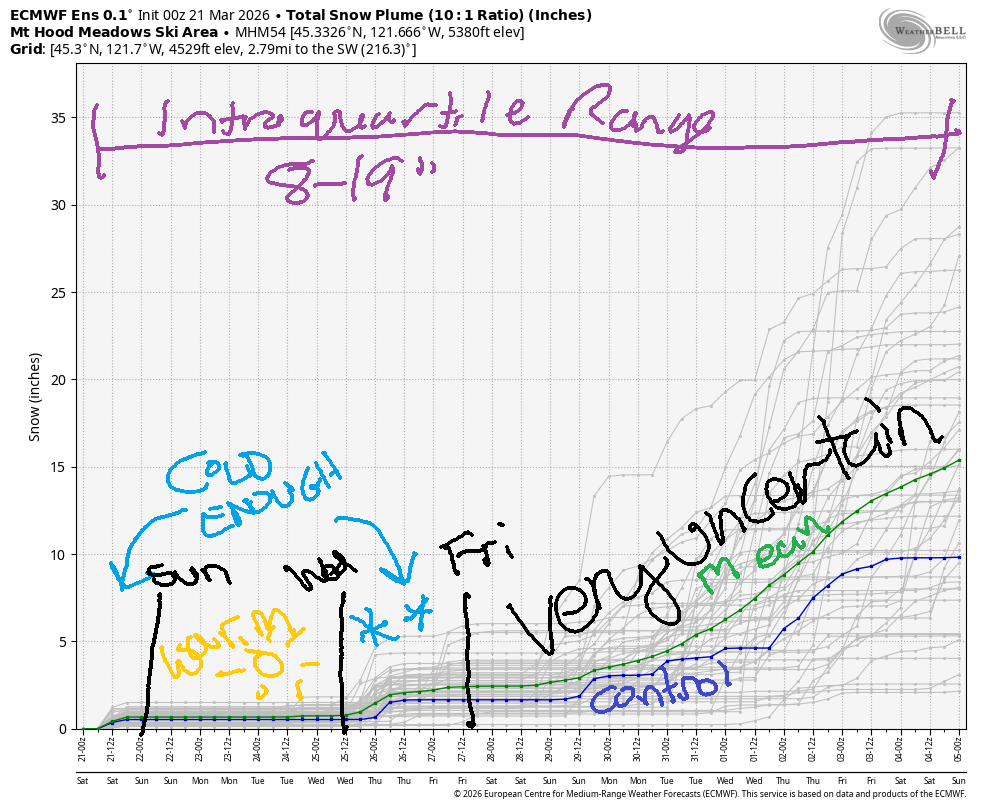
Beyond next Friday, the weather looks very uncertain. Through the first week of April, the intraquartile range for snow is just 8-19”. Meadows and Timberline are hanging on (minus HRM), and Meadows Nordic is just barely hanging in there. Teacup: done.
Short term Mt Hood snow forecast
By the time the lifts are spinning on Saturday, the clouds should be breaking up, and temps should be dropping. EDIT: it’s sunny as of 8am. Wind prior to dawn was strong enough to take down many lifts, but it should be backing off. The snow level will be around 4000′ early with the free air freezing level falling to around 2500’under clear sky overnight. Temps fall to the upper 20s at 5000′. Just a trace of snow is forecast this morning. Wind will be NW 35 early, NW 20-30 mid-morning, and NW 15-20 overnight. Snow surface at 5am was slushy, but it’s likely to set up at least a little with the dropping temps. There has not been enough new snow up high to significantly change the snow surface.
Sunday starts clear. Although temps won’t be all that cold, the combo of clear sky and light-enough wind should allow the snow to snap/freeze. The free air freezing level risers from 2500′ in the morning to 8000′ in the afternoon to 9000′ overnight with temps rising to 40F at 5000′. Should be a good day for corn snow! Wind will be NW 15-20 early, light/variable in the afternoon, and SW 5-15 overnight.
Extended Mt Hood Snow Forecast
Monday starts with a few high clouds and stays high overcast. The free air freezing level will be 9000′ in the morning and will slowly fall to 7500′ after midnight. Temps will be near 40F, but thanks to clear-enough sky overnight, the snow is likely to snap. Should be a decent corn snow day again. Wind will be SW 5-15 all day and SW 15-25 after midnight.
A weather system is forecast on Tuesday. There’s quite a bit of uncertainty about 1) snow level and 2) precipitation amounts. As of right now, the ensembles have 1-3” snow. Looking deeper into the future, we have a brief cold spell Tuesday-Wednesday followed by warming. Starting next Friday, uncertainty is too vast to make predictions. Go get yourself some playtime in the snow while it’s still possible!
Was that helpful? I knew it was! Guess what? All of this crucial work – from your personal wind and snow reports to the invaluable TATAS updates – is made possible by my relentless efforts. Maintaining this labor of love isn’t easy. Each daily forecast takes hours. Website hosting, weather model access, and back-end admin work takes time and money. That’s where you come in.
YOUR CONTRIBUTION MAKES A DIFFERENCE
- SUPPORT ACCURATE, HYPER-LOCAL WEATHER FORECASTING
- ENABLE ACCESS FOR ALL, EVEN THOSE WITH LESS MEANS
- SUPPORT A COOL HUMAN WHO WORKS HARD SO YOU CAN PLAY
Take a moment to click one of the buttons below. Donate $19.99 or more (how much does this forecast enhance your life?) and get the email in your inbox. Whether it’s a renewing subscription (auto-renew) or a one-time donation, every contribution makes a real difference. Help me keep this labor of love alive, so we can all continue playing, commuting, and living in the Gorge with peace of mind and the best weather forecasts possible. Thank you!


Hood River, Oregon 97031


GORGE WIND FORECAST
If you’re still seeing yesterday’s and it’s after 9am, try opening this in an incognito window
SHORT-TERM gorge wind forecast
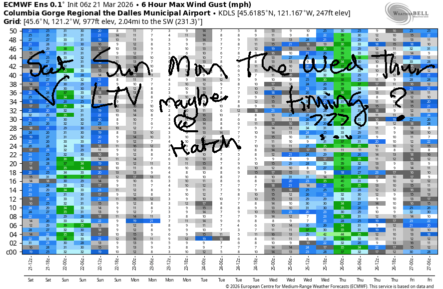
Hi friends! Nice sunny day here in the Hood with west wind on tap. Today’s your best chance in the next week or so. While there may be an opportunity on Tuesday or Wednesday, it’s going to be timing-dependent.
Saturday started with clouds to the west, sun in Hood River, and high pressure building offshore as a cold front shifts inland. Pressures at 7am were 30.22/30.13/30.13 for 0.09/0.00 gradients. Westerlies were 17-20mph from Stevenson to Swell with lighter wind to the east. Give the desert a little time to warm, and we should see 21-24 from Stevenson to Hood River with 17-20 at Doug’s.
Afternoon wind becomes gusty at 19-22mph from Stevenson to Hood River and rises to 23-26mph from Mosier to Rufus with a shot at a little more wind between Rowena and Doug’s. Should the clouds in the metro area last today (models say they’ll dissipate), the wind will exceed predictions. River flow over the last 24 hours was 200-228kcfs at The Dalles and 211-241kcfs at Rufus (too much, really, for paddling at Rufus). River temp is 46F, and high temp forecast is 55F near Hood River and 60F out in the desert.
RIVER FLOW FOR SITES BETWEEN AVERY (EAST OF THE DALLES) AND RUFUS: CLICK HERE FOR JOHN DAY DAM FLOW.
RIVER FLOW FOR SITES BETWEEN STEVENSON AND DOUG’S BEACH (WEST OF THE DALLES): CLICK HERE FOR THE DALLES DAM FLOW

LONGER-TERM gorge wind forecast
Sunday starts with very light west wind or perhaps no wind at all. Easterlies pick up to 15mph near Stevenson and 10mph near Rooster Rock late morning before dropping back to 10mph in the afternoon. High temp: 59F with some high clouds.
Monday starts light and variable. Models have some uncertainty. They do suggest a slow build to 17-20mph between Stevenson and Hood River with 14-17mph from Lyle to Doug’s in the afternoon. High temp: right around 60F with increasing high clouds.
A weather system moves inland sometime on Tuesday. West wind is possible ahead of this system and following its passage. The timing and strength of wind is uncertain. Beyond that… not much sign of windy-enough days in our future, but I’ll keep watching it for you and let you know about the day-to-day changes. See you on the Nch’i Wana today!

BARE BONES HOOD RIVER WEATHER FORECAST
Partly cloudy this morning. Sunny later. Temps start near 50 and rise to the mid 50s. Moderately strong westerlies. Nor rainbows. Sunday will be partly Nothing then sunny then partly high cloudy. Temps start in the low 30s and rise to the upper 50s. Light and variable wind. No rainbows. Monday will be partly cloudy then high cloudy. Temps star in the upper 30s and rise to the upper 50s. Light/variable wind early. Moderate westerlies later. No rainbows.
TEMIRA’S AWESOME TRAVEL ADVISORY SERVICE
HYPERLOCAL WEATHER FORECAST FOR THE COLUMBIA GORGE
THE DALLES, HOOD RIVER, WHITE SALMON, TROUT LAKE, STEVENSON, CASCADE LOCKS, PARKDALE, ODELL, HUSUM, BZ, MILL A, WILLARD, GOLDENDALE, RUFUS, ARLINGTON, boardman
Good morning, neighbors! Spring is in the air and on the calendar. Trees are starting to leaf out, and all sorts of flower are blooming. So. Happy! Spring continues this week with minimal rain (Tuesday) and plenty of 55-60 degree high temps. Our biggest weather concern is a high likelihood of frost on Sunday morning.
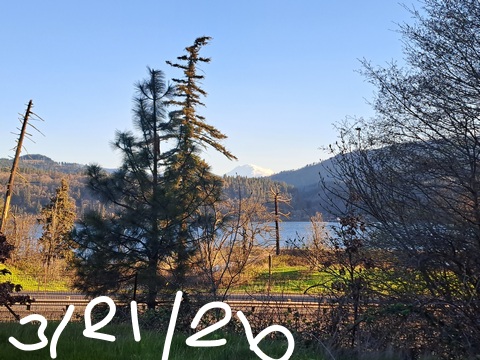
Glenwood this morning
It’s currently Saturday, and it’ll be Saturday all day long. We start with clouds to the west, sun in the middle, and rain east of Biggs. Even the Arlington Triangle is wet! Up in Glenwood, it’s 46F this morning despite the clear sky and thanks to the wind.
Today’s Gorge weather forecast
For the rest of today… clouds burn off and leave the entire Gorge sunny. Temps rise to 55F west of Wishram. East of Wishram: low 60s. We’ll have west wind at 25mph (ish) from Stevenson to Hood river this morning and 15-20mph from Mosier to The Dalles. Afternoon wind holds in the west and rises to 15-20mph near Rufus. Less wind is expected out in the warm, sunny desert, where the tumbleweeds will be looking at flights to the Hood River area. Tumbleweeds are Nature’s Wind Johnnies – they too like downwinding!
Sunday’s Gorge weather forecast
Overnight… the wind fades, the sky stays clear, and dewpoints fall into the upper 20s even near the Nch’i Wana (Columbia). We’re set for a frosty Sunday morning at all elevations. Parkdale: mid 20s. Glenwood: low 20s. Lowlands: 29-32. There may be just enough high clouds for a pretty sunrise, and there are likely to be enough clouds for a pretty sunset. Max temps rise to within a couple degrees of 60F all through the Gorge. Wind will be light and variable most locations with E 10-15mph near Stevenson.
Extended Gorge weather forecast
Monday starts partly cloudy to the west and partly high overcast to the east with temps in the upper 30s. Afternoon: more high clouds and max temps around 60F. Wind will be calm early. Afternoon wind rises to 15-20mph west of The Dalles and stays light to the east.
A weak system brings a little rain on Tuesday afternoon (timing still TBD), and then we’re back to dry weather for the rest of next week. Uncertainty from Friday onward leaves us simply accepting that it’s spring. Nothing extreme is hinted at either in terms of temps or precipitation. Safe travels. -TATAS
HEY! DON’T STOP READING! Is this community-focused forecast helpful to you? It sure is! It takes me a couple hours a day to write. Please join your friends and neighbors in contributing to keep it going. Venmo: @thegorgeismygym PayPal: twomirrors@gmail.com USPS: Temira / PO Box 841 / Hood River, Oregon 97031 You can test out the forecast subscription for a few days for free by signing up below. Easy! Do it!
JONES BEACH, SAUVIE ISLAND, & COAST FORECAST
ON WINTER VACATION UNLESS DESPERATELY NEEDED.

Leave a Reply