

MT HOOD SNOW FORECAST

Hey skiers and snowboarders! Ski season keeps on keeping on. Today’s going to be a warm and sunny day on the slopes. Timberline and Meadows have made it their mission to stand up against Ma Nature and get you as much skiing as possible. Get it while you can! We’re expecting basically zero precipitation through next weekend. Temps will be warm on the slopes through Monday and will turn cooler starting Tuesday. With cooler temps next week, we should see the snowpack refreeze. That would give us some awesome days of corn snow!
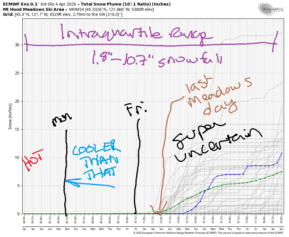
Short term Mt Hood snow forecast
Saturday isn’t going to be a corn snow day – this week’s fresh snow hasn’t made it to granular yet. Make sure you wax warm today, as it’s likely to get sticky quickly. The free air freezing level will be 9000′ early and 10,000′ this afternoon with temps rising to the low-mid 50s at 5000′. Wind will be light and variable all day turning to S 5-15mph overnight.
Sunday will be high overcast with filtered sun. The free air freezing level hovers at 10,000′ all day. Those clouds may prevent temps from dropping below freezing overnight. Afternoon temps rise to the upper 50s. Wind will be S 5-15mph all day and will shift to W 5-10mph overnight.
Extended Mt Hood Snow Forecast
Monday will be clear to start. High clouds join in the afternoon ahead of an incoming cold, dry front. Expect the freezing level to be around 10,000′ all day. It drops as low as 2000′ overnight, but this really depends on how far south the cooler air mass penetrates. Wind will be W 5-10 in the morning, W 25 in the afternoon, and W 35-40 overnight.
Tuesday looks sunny and cooler with the freezing level around 4000′ during the day and 3000′ after midnight. Wind will be W 35-40 in the morning, WNW 15-20 in the afternoon, and light westerly overnight. Similarly cool, not-very-windy, mostly sunny weather is on tap for Wednesday, Thursday and Friday. Beyond that, uncertainty increases, so that’s the end of the forecast for today. Enjoy your day on the snow!
Was that helpful? I knew it was! Guess what? All of this crucial work – from your personal wind and snow reports to the invaluable TATAS updates – is made possible by my relentless efforts. Maintaining this labor of love isn’t easy. Each daily forecast takes hours. Website hosting, weather model access, and back-end admin work takes time and money. That’s where you come in.
YOUR CONTRIBUTION MAKES A DIFFERENCE
- SUPPORT ACCURATE, HYPER-LOCAL WEATHER FORECASTING
- ENABLE ACCESS FOR ALL, EVEN THOSE WITH LESS MEANS
- SUPPORT A COOL HUMAN WHO WORKS HARD SO YOU CAN PLAY
Take a moment to click one of the buttons below. Donate $19.99 or more (how much does this forecast enhance your life?) and get the email in your inbox. Whether it’s a renewing subscription (auto-renew) or a one-time donation, every contribution makes a real difference. Help me keep this labor of love alive, so we can all continue playing, commuting, and living in the Gorge with peace of mind and the best weather forecasts possible. Thank you!


Hood River, Oregon 97031


GORGE WIND FORECAST
If you’re still seeing yesterday’s and it’s after 9am, try opening this in an incognito window
SHORT-TERM gorge wind forecast
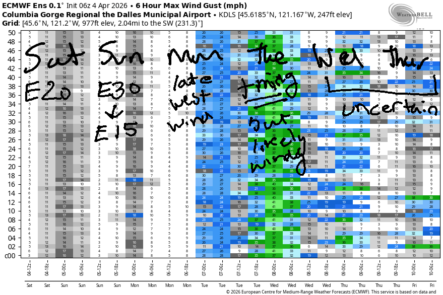
Hey friends! A gorgeous weekend is on tap. While the wind won’t be all that strong, the weather will be spectacular. Moderate easterlies stick around Saturday and Sunday. West wind returns Monday and persists into at least Tuesday. Beyond that, uncertainty rises. Let’s take a look at the details!
Saturday kicked off with pressures of 30.33/30.36/30.37 for light offshore gradients. Easterlies climb to 20mph at Iwash/Rooster Rock and 15-20mph at Stevenson. After 2pm, the wind fades and finishes up at 15mph at both spots. Viento: 15mph or so maximum today. River flow over the last 24 hours was 189-223kcfs, river temp is 47.3F, and high temp forecast is 70F with increasing high clouds.
RIVER FLOW FOR SITES BETWEEN AVERY (EAST OF THE DALLES) AND RUFUS: CLICK HERE FOR JOHN DAY DAM FLOW.
RIVER FLOW FOR SITES BETWEEN STEVENSON AND DOUG’S BEACH (WEST OF THE DALLES): CLICK HERE FOR THE DALLES DAM FLOW

LONGER-TERM gorge wind forecast
Sunday, thanks to a heat low on the west side, starts with stronger easterlies: 30-35mph at Iwash Rock and 20-25mph at Stevenson. Both spots hold at 20-25mph or so through late morning or early afternoon before dropping to 15mph for the rest of the day. High temp: 73F with high clouds.
A cold front approaches on Monday and turns the wind around (right round baby right round round round). After a dead calm start, westerlies slowly build. Timing will be everything – as of right now, the strongest wind is forecast to happen overnight. Models do give us 17-20mph from Stevenson to Hood River by 2pm and potentially 23-26mph for the Executive Session (after 5pm, now that there’s enough daylight). Cross your fingers for a shift in timing, because models do hint at nuking westerlies overnight!
Tuesday’s wind is also dependent on the timing of that system. As of right now, models suggest TJ’s Dawn Patrol will be the strongest wind, but maybe that will change. Either way, the setup is decent, so pencil in a Tuesday session on the Nch’i Wana. Beyond Tuesday, there’s just too much uncertainty, so I’ll leave you for now. Stay safe out there, and enjoy the warm, sunny weather!

BARE BONES HOOD RIVER WEATHER FORECAST
Clear sky this morning. High clouds later. Temps start in the upper 30s and rise to 70. Light easterlies. No rainbows. Sunday will be high overcast. Temps start in the upper 40s and rise to the low 70s. Light easterlies. No rainbows. Monday will be clear then partly high cloudy. Temps start in the upper 40s and rise to the mid 70s. Calm wind early. Moderate and building westerlies later. No rainbows.
TEMIRA’S AWESOME TRAVEL ADVISORY SERVICE
HYPERLOCAL WEATHER FORECAST FOR THE COLUMBIA GORGE
THE DALLES, HOOD RIVER, WHITE SALMON, TROUT LAKE, STEVENSON, CASCADE LOCKS, PARKDALE, ODELL, HUSUM, BZ, MILL A, WILLARD, GOLDENDALE, RUFUS, ARLINGTON, boardman
Good morning, neighbors! Spectacular weather is on tap for today, at least in my opinion, and I like to think I have good taste! Warm weather, 70+, continues through Monday, after which a cold front sweeps through and takes high temps back down to 60F or so. That’s still pretty damned nice and is actually right at “normal” for this week.
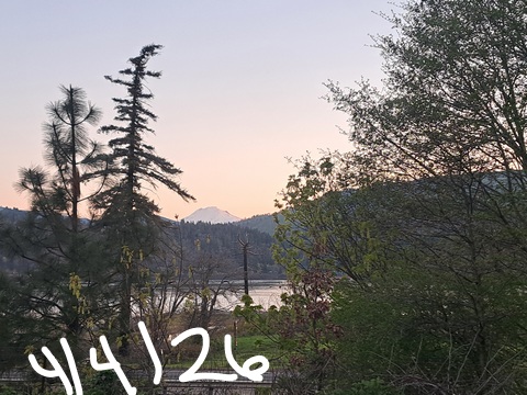
Glenwood this morning
Glenwood is normal today: 26F up there to start, which has everyone dancing for joy at yet another winning cold temp. Trout Lake made it down to 28, the Upper Valley is running 31-38, and Mosier is similar to the Parkdale area this morning. In Goldendale, where a 200′ tall flagpole is proposed (YUGE! CAN’T WAIT TO SEE THE PRIDE FLAG UP THERE!), it’s 32F, and Centerville, the second-coldest place in the gorge, it’s 29F.
Today’s Gorge weather forecast
We’re all gonna be seeking shorts and T-shirts today (I’m going with overalls, sports bra, and no underwear for my sexy outfit) as temps climb to 70F all across the lowlands. Grab your shades and your empty pots and head to Fred Meyer for the annual Fuchsia Sale, where they’ll fill your pots with soil for the plants you purchase. As you wait in line, you’ll encounter light east wind (15-20mph near Cock Rock and Stevenson) and sunny sky. Wait in line long enough, and a few high clouds will arrive.
Sunday’s Gorge weather forecast
High clouds thicken overnight into Sunday like a pen*s spotting TATAS. If those clouds thicken enough, they’ll act like a blanket and keep us warm overnight. Given how warm it’ll be, you might want to subtract 1 from the number of blankets you plan to use. As of right now, temps are forecast to stay above 40F everywhere Sunday morning. By afternoon, we’re looking at 73-74F and high clouds. East wind persists. At Iwash (dick) Rock, it’ll be 30-35mph in the morning and 15-20mph in the afternoon. Stevenson: 20-25mph. Elsewhere: light wind – up in the hills we’re expecting south wind at 5-15mph.
Monday’s Gorge weather forecast
Another warm start is forecast on Monday as temps at 850mb (5000′) hover around +11C. Clear sky in the morning gives way to partly cloudy sky in the afternoon. Max temps… wait for it… 74F to the west, 77F in The Dalles, and 79F in the desert. HOT! After a calm start, westerlies slowly build to 20-25mph between Hood River and The Dalles late in the day. Strong westerlies persist overnight. This upsets the Boardheads – they prefer strong wind to occur in the daylight hours.
Extended Gorge weather forecast
We’re left with a cooler, dry air mass on Tuesday morning along with strong west wind. This is likely to protect most of us from frost, but the Upper Valley may see temps dip. We’ll check out the details as we get closer. Model uncertainty rises on Wednesday, but generally speaking, mild (60F) temps stick around all week with the free air freezing level around 4000′. Frost is possible in this setup in our higher elevations, so we’ll keep watching. Now… get out and enjoy the fuck outta this beautiful day! Safe travels. -TATAS
HEY! DON’T STOP READING! Is this community-focused forecast helpful to you? It sure is! It takes me a couple hours a day to write. Please join your friends and neighbors in contributing to keep it going. Venmo: @thegorgeismygym PayPal: twomirrors@gmail.com USPS: Temira / PO Box 841 / Hood River, Oregon 97031 You can test out the forecast subscription for a few days for free by signing up below. Easy! Do it!
JONES BEACH, SAUVIE ISLAND, & COAST FORECAST
ON WINTER VACATION UNLESS DESPERATELY NEEDED.

Leave a Reply