

MT HOOD SNOW FORECAST

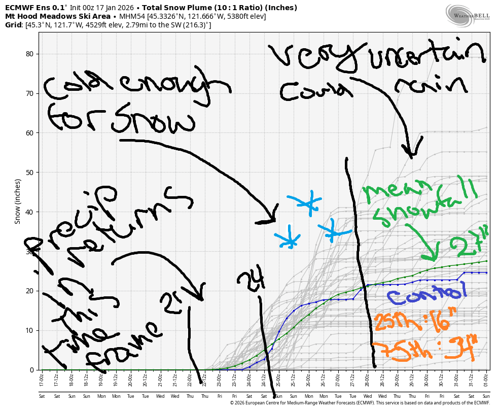
Hey skiers and snowboarders! Dry weather continues through the middle of next week. Extensive uncertainty is present in the models starting around next Wednesday – while it does appear there’s some moisture headed our way, and while it does appear it will be cold enough for snow for at least a few days, it’s impossible to predict the details. That’s quite clear when we look at the intraquartile range for snowfall through 1/31: the 25th percentile calls for 16” of snow on Mt Hood by the end of the month, and the 75th percentile has 34” of snowfall. As always, vote for the high end!
Short term Mt Hood snow forecast
We’ll have no snow today, Saturday. Only liquid sunshine falls on Mt. Hood. The free air freezing level will be above 10,000′ all day. Temps max out between the low 40s and low 50s depending on which competing air mass wins the battle. At the lowest elevations, temps will likely be much cooler thanks to a strong inversion. Wind today will be light and variable.
Sunday looks nearly identical. Snow conditions are highly variable depending on aspect and condition: there’s some granular, some scoured spots, a weird dry hardpack-y snow that results from radiational cooling to hardpack. If it gets warm enough today, we’ll see areas of corn snow. Wax: universal?
Extended Mt Hood Snow Forecast
Sunshine continues on MLK day, Monday. Remember that Meadows is hosting Rotary Night – proceeds benefit Hood River’s scholarship fund. During the day Monday, we’ll have sunshine. Clear sky sticks around overnight. Temps max out between 40F and 50F depending on where you are in both location and elevation. Wind will be light easterly in the morning and will build to W 20-25 overnight.
Warm, sunny weather continues on Tuesday with the free air freezing level above 10,000′ and temps maxing out in the upper 40s. Wind will be W/WNW 20-25 in the morning and variable to 10mph in the afternoon. We may start to see high clouds on Wednesday, but precipitation is low probability. Sometime late next week, precipitation will return. It does look like we could see snow for a few days, but models are concerningly in consensus on warmer weather returning after a few days of cold. Let’s hope they decide to change! Enjoy the sunny slopes today!
Was that helpful? I knew it was! Guess what? All of this crucial work – from your personal wind and snow reports to the invaluable TATAS updates – is made possible by my relentless efforts. Maintaining this labor of love isn’t easy. Each daily forecast takes hours. Website hosting, weather model access, and back-end admin work takes time and money. That’s where you come in.
YOUR CONTRIBUTION MAKES A DIFFERENCE
- SUPPORT ACCURATE, HYPER-LOCAL WEATHER FORECASTING
- ENABLE ACCESS FOR ALL, EVEN THOSE WITH LESS MEANS
- SUPPORT A COOL HUMAN WHO WORKS HARD SO YOU CAN PLAY
Take a moment to click one of the buttons below. Donate $19.99 or more (how much does this forecast enhance your life?) and get the email in your inbox. Whether it’s a renewing subscription (auto-renew) or a one-time donation, every contribution makes a real difference. Help me keep this labor of love alive, so we can all continue playing, commuting, and living in the Gorge with peace of mind and the best weather forecasts possible. Thank you!


Hood River, Oregon 97031


GORGE WIND FORECAST
If you’re still seeing yesterday’s and it’s after 9am, try opening this in an incognito window
SHORT-TERM gorge wind forecast
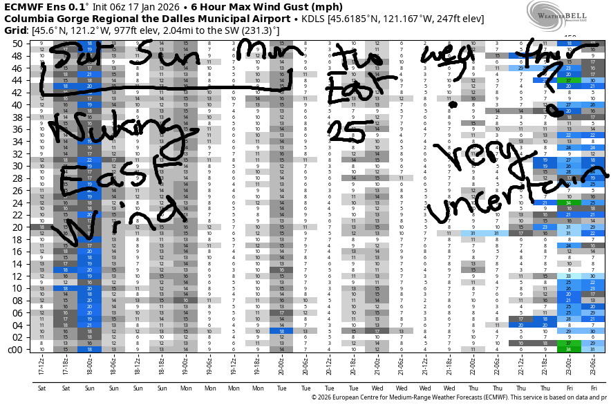
Hi friends! Nuking easterlies continue for at least a couple more days – Iwash (Rooster) Rock started today with an average speed of 58mph. It’s Saturday, by the way!
Today’s early pressures were 30.30/30.58/30.60 thanks to a heat low along the coast and dense, high-pressure air in the desert. Easterlies hold at 50-60mhp near Iwash this morning and rise to 35-40mph at Stevenson with 25mph at Viento. Afternoon wind falls to 45mph at Iwash and 30-35mph at Stevenson. River flow over the last 24 hours was 182-214kcfs, river temp is 42.8F, and high temp forecast is 42F with sunshine in the windy zones.
RIVER FLOW FOR SITES BETWEEN AVERY (EAST OF THE DALLES) AND RUFUS: CLICK HERE FOR JOHN DAY DAM FLOW.
RIVER FLOW FOR SITES BETWEEN STEVENSON AND DOUG’S BEACH (WEST OF THE DALLES): CLICK HERE FOR THE DALLES DAM FLOW

LONGER-TERM gorge wind forecast
Sunday sees the pattern break down just a little. Easterlies hold at 40-50mph all day at Iwash and hover around 30mph at Stevenson. High temp: 43F with sunshine in the windy zones. Monday looks just like Sunday.
Lesser easterlies, perhaps 20-25mph, are forecast on Tuesday. Models agreement diminishes on Wednesday. It’s unclear at this point what we’ll see, so I’ll leave it here for now. Make sure you’re dressing extra warmly if you’re out on the river in these conditions. Have a PFD and an emergency plan, and keep an eye on your buddies!
BARE BONES HOOD RIVER WEATHER FORECAST
Nothing today. Might partially break up later. Temps start in the mid 30s and rise to the low 40s. Light to moderate easterlies. No rainbows. Same damned weather the next two days!
TEMIRA’S AWESOME TRAVEL ADVISORY SERVICE
HYPERLOCAL WEATHER FORECAST FOR THE COLUMBIA GORGE
THE DALLES, HOOD RIVER, WHITE SALMON, TROUT LAKE, STEVENSON, CASCADE LOCKS, PARKDALE, ODELL, HUSUM, BZ, MILL A, WILLARD, GOLDENDALE, RUFUS, ARLINGTON, boardman
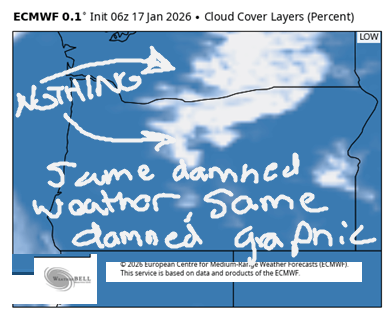
Good morning, neighbors! Not much to say – yesterday’s weather repeats through at least Tuesday. We’ll have a morning Nothing cloud every day, and on some days the Nothing will at least partially break up in the afternoon. Nothing will result in areas of freezing fog and frosty roads both in the Nothing and above it. Details of our eventual escape from this weather pattern are still unclear.
Checking out the Gorge this morning, we’ve got Nothing most places. Glenwood is 30F this morning, which means it’s either windy or Nothing. Parkdale is in the upper 20s, and Middle Mountain is 26F, indications that they may be above the Nothing, and indications that they almost certainly have frosty roads. Glenwood is sulking because their title of “Coldest Town In The Gorge” has been usurped in this rather weird winter. Other news… no sign of !CE this morning – with 3000 cubes of that cold stuff currently enacting a siege in Minnesota, there are less around here.
Weather for today and the next four days: Nothing east of Home Valley in the morning. Sunshine to the west thanks to blasting east wind: 40-60mph at Iwash (It’s NOT a damned rooster) Rock and 30-40mph near Cascade Locks daily. Less wind Tuesday if that’s important to you. Nothing will partially break up in the afternoon – sun breaks are most likely up in elevation and away from the Nch’i Wana. Out in the desert: Nothing all day most days. High temps max out around 40F in the lowlands. Low temps will be in the upper 20s to low 30s up high and 35-40F in the lowlands.
At some point in the latter half of next week, we’ll emerge from this pattern. It’s unclear if we’ll emerge unscathed by snow or ice. Given the temps and lack of arctic air, a massive silver thaw seems unlikely, but we can’t totally rule out some sort of winter weather event until the details become more clear. Safe travels. -TATAS
HEY! DON’T STOP READING! Is this community-focused forecast helpful to you? It sure is! It takes me a couple hours a day to write. Please join your friends and neighbors in contributing to keep it going. Venmo: @thegorgeismygym PayPal: twomirrors@gmail.com USPS: Temira / PO Box 841 / Hood River, Oregon 97031 You can test out the forecast subscription for a few days for free by signing up below. Easy! Do it!
JONES BEACH, SAUVIE ISLAND, & COAST FORECAST
ON WINTER VACATION UNLESS DESPERATELY NEEDED.
