

MT HOOD SNOW FORECAST

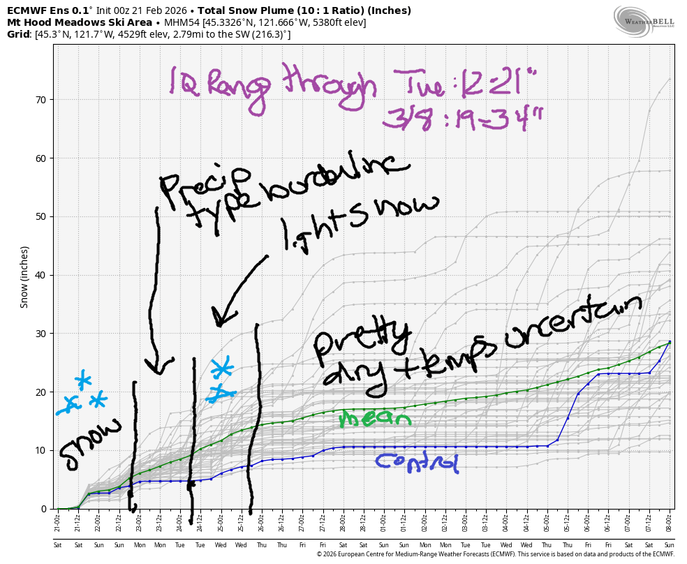
Hey skiers and snowboarders! Conditions are decent on Mt Hood right now despite the low snowpack, and more snow is on the way today (Saturday). Precipitation continues through Tuesday morning as a weak atmospheric river makes contact with the Pacific Northwest. Unfortunately for those of you craving certainty, there’s very little certainty in the models right now.
The amount of snow vs. rain, and the temps on the slopes, are all going to be related to exactly where the moisture associated with the atmospheric river lines up. Generally speaking, the Euro suggests we’ll be wet and warm starting midday Sunday. The GFS is more hopeful, but is far from guaranteeing snow. Temps drop again Tuesday, but there won’t be much moisture around. Through Tuesday, the intraquartile range is 12-21”. Through 3/8, it’s 19-32”.
Short term Mt Hood snow forecast
Saturday, however, looks great! The snow level will be 500-1000′ near Mt Hood this morning and will slowly rise to 5000′-5500′ tonight. We’re expecting about 0.5” to 0.6” water equivalent today with temps rising from 20F to 32F. Call it 5-6” new snow that starts as powder and turns heavier as the day goes on. Overnight, the precip shuts off. Wind today will be S 10-20 in the morning, S 15-25 in the afternoon, and SW 25-45 after midnight. Snow surface will be packed powder with some hardpack and granular in the high-traffic areas. Nordic wax will be violet.
Uncertainty enters the picture on Sunday morning as temps at 5000′ rise to 32-34F. That’s right on the edge for wet snow; if the precip intensity is high enough, we could see snow linger at 5000′. As I mentioned earlier, the models are uncertain about the temps and location of precip. If we listen to the GFS deterministic, we’ll have the snow level at +/- 5000′ all day with 0.3” water equivalent during the day and 0.9” water equivalent overnight. If this comes in as snow, we’re looking at 6-9” wet snow. If not, well, rain. My best guess for Sunday is wet snow all day. Wind will be SW 25-45 for the 24 hour period, strongest during the daylight hours.
Extended Mt Hood Snow Forecast
Uncertainty lingers into Monday with the GFS giving us a shot at snow, especially Monday night, and the Euro bringing in warmer temps with rain likely at 5000′. I can’t even tell you how much moisture we’ll pick up because the spread is so high. At least an inch? Wind will be SW 25-45 until Monday night when it switches to NW, temps cool, and we pick up at least a little bit of fluffier snow.
Here’s hoping the models have more clarity tomorrow morning! Starting Tuesday, high pressure takes over with mostly dry, mostly sunny, cooler weather. Beyond next Thursday, model uncertainty increases – one day gives us a 10C range of temps at 850mb… completely impossible to make a forecast based on that. I’ll leave it here for now today. Enjoy the snow!
Was that helpful? I knew it was! Guess what? All of this crucial work – from your personal wind and snow reports to the invaluable TATAS updates – is made possible by my relentless efforts. Maintaining this labor of love isn’t easy. Each daily forecast takes hours. Website hosting, weather model access, and back-end admin work takes time and money. That’s where you come in.
YOUR CONTRIBUTION MAKES A DIFFERENCE
- SUPPORT ACCURATE, HYPER-LOCAL WEATHER FORECASTING
- ENABLE ACCESS FOR ALL, EVEN THOSE WITH LESS MEANS
- SUPPORT A COOL HUMAN WHO WORKS HARD SO YOU CAN PLAY
Take a moment to click one of the buttons below. Donate $19.99 or more (how much does this forecast enhance your life?) and get the email in your inbox. Whether it’s a renewing subscription (auto-renew) or a one-time donation, every contribution makes a real difference. Help me keep this labor of love alive, so we can all continue playing, commuting, and living in the Gorge with peace of mind and the best weather forecasts possible. Thank you!


Hood River, Oregon 97031


GORGE WIND FORECAST
If you’re still seeing yesterday’s and it’s after 9am, try opening this in an incognito window
SHORT-TERM gorge wind forecast
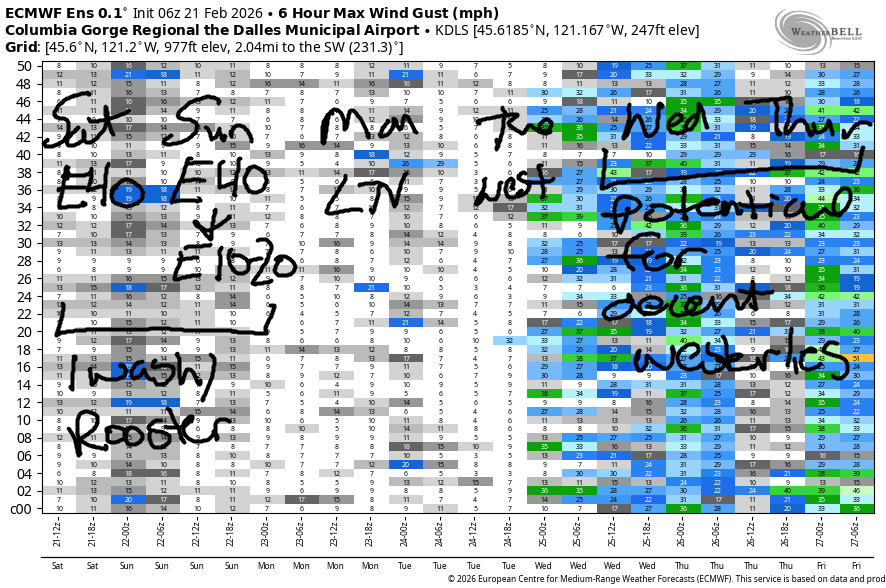
Hi friends! Easterlies and rain are forecast for Saturday and Sunday. Variable wind is in the forecast on Monday. From Tuesday n through Thursday, we’re expecting some sort of west wind, but models and their ensembles are far from agreeing on the details of this extended forecast.
Saturday starts with pressures of 29.93/30.09/30.14 and east wind. Stevenson: :25mph, Iwash (Rooster) Rock: 36mph; Viento: 16mph. Midday wind rises to 30-35mph at Stevenson and 45mph at Iwash Rock and holds overnight. River flow over the last 24 hours was 161-189kcfs, river temp is 41.9F, and high temp forecast is 41.7F with rain most of the daylight hours.
RIVER FLOW FOR SITES BETWEEN AVERY (EAST OF THE DALLES) AND RUFUS: CLICK HERE FOR JOHN DAY DAM FLOW.
RIVER FLOW FOR SITES BETWEEN STEVENSON AND DOUG’S BEACH (WEST OF THE DALLES): CLICK HERE FOR THE DALLES DAM FLOW

LONGER-TERM gorge wind forecast
Sunday starts with easterlies at 40mph at Iwash and 35mph at Stevenson. After 10am, the wind drops fast and then bounces around in the 15-25mph range at both spots for the rest of the day. High temp: 46F with rain all day long.
Monday starts with easterlies under 15mph in the usual spots. After 1pm, the wind (probably) turns light westerly at 15mph or less. Models suggest somewhat better chances for west wind on Tuesday. As of this morning, the Euro is optimistic about Wednesday and Thursday. The GFS also suggests westerlies, but quickly builds high pressure inland and shuts down the wind. Both models agree on high pressure entering the picture which gives us at least some chance for west wind. Fingers crossed!
BARE BONES HOOD RIVER WEATHER FORECAST
Drizzle or snain this morning with rain later and dry, mostly cloudy weather after 4pm. Temps start in the mid 30s and rise to the upper 30s. Light easterlies. 7% chance of rainbows. Sunday will be rainy. Temps start in the low-mid 30s and rise to the mid 40s. Light easterlies. 1% chance of rainbows. Monday will be rainy. Temps start in the upper 30s and rise to the upper 40s. Light easterlies in the morning. Light westerlies late in the day. 18% chance of rainbows.
TEMIRA’S AWESOME TRAVEL ADVISORY SERVICE
HYPERLOCAL WEATHER FORECAST FOR THE COLUMBIA GORGE
THE DALLES, HOOD RIVER, WHITE SALMON, TROUT LAKE, STEVENSON, CASCADE LOCKS, PARKDALE, ODELL, HUSUM, BZ, MILL A, WILLARD, GOLDENDALE, RUFUS, ARLINGTON, boardman
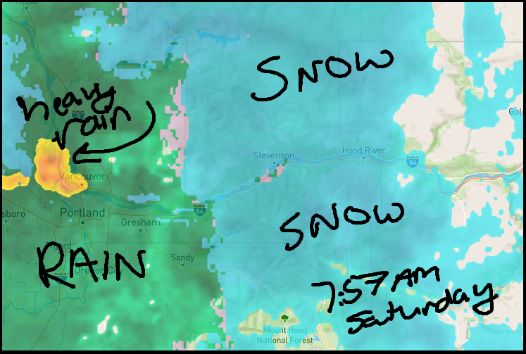
Good morning, neighbors! Snow is falling above 500′ or so this morning, but it’s refusing to snow at my house yet again. UPDATE: I just saw a couple wet snowflakes mixed in with the rain. Hopefully you have snow if you want snow and don’t have snow if you don’t want snow! I didn’t see any !CE this morning in Hood River, so that’s good. There may be ice on the roads: Centerville, Goldendale, Dufur area, and the Upper Valley are all below freezing to start the day. Driving the passes? Expect accumulating snow all day today and very heavy traffic on 35 thanks to high demand for snow sports. Forecast for the next few days, through Tuesday morning, looks quite wet for many of us. After that, the weather turns mostly dry as high pressure sets up over the PNW for a bit.
Today’s Gorge weather & Glenwood’s opening play
Saturday started with light rain. By mid-morning the intensity picks up with heavy rain to Hood River, moderate rain for The Dalles and south Wasco n’ Sherman Counties, and light rain almost to the Arlington Triangle. Given the intensity of the precip, snow is likely to accumulate above 500′ before temps aloft warm and the precip switches to rain. Snow totals: 2-4” for Willard, Stabler, Trout Lake, Snowden, Underwood, Middle Mountain, York Hill, and Parkdale. 1-2” for High Prairie, south Wasco, Sherman, Glenwood (33F to start the day!), Appleton. Trace to an inch for White Salmon, Hood River, Mosier, Lyle. Driving to the metro area? Expect heavy rain from 7am to 1pm along with east wind at 40mph near Iwash (Executive power is not unlimited) Rock and 30mph near Stevenson. Temps today max out near 40F (44F way out in the desert).
Sunday’s Gorge weather forecast
Overnight, precip stops. Temps at 5000′ rise above freezing. This should end our snow risk, but it won’t end the rain. After a mid 30 degree start, temps on Sunday rise to 45-47F in the lowlands for the central Gorge and low 50s (wow) out in the Columbia Basin. Rain returns around 9am, but stays west of The Dalles until 1pm or so. Rain intensity will be heavy enough to make the drive to/from the metro area unpleasant. After 1pm, the rain slides east, but it doesn’t stop for areas to the west until after 4pm. That break will be short-lived. Rain returns in the evening. Sunday wind: E 40mph near Iwash (prosecute the pedo elites!) Rock and 35mph near Stevenson in the morning with 10-20mph in the afternoon.
Extended Gorge weather forecast
Model uncertainty increases Monday into Tuesday as models struggle to pinpoint the exact target of an atmospheric river. This system has temps at 1-3C at 850mb, which means the passes should be clear of snow and we should receive rain. However, it’s very unclear how much rain. Maybe a lot. Maybe not. By Tuesday morning, dry weather returns. High temps Monday, Tuesday, and Wednesday max out near 50F. That’s it for now. Safe travels. -TATAS
HEY! DON’T STOP READING! Is this community-focused forecast helpful to you? It sure is! It takes me a couple hours a day to write. Please join your friends and neighbors in contributing to keep it going. Venmo: @thegorgeismygym PayPal: twomirrors@gmail.com USPS: Temira / PO Box 841 / Hood River, Oregon 97031 You can test out the forecast subscription for a few days for free by signing up below. Easy! Do it!
JONES BEACH, SAUVIE ISLAND, & COAST FORECAST
ON WINTER VACATION UNLESS DESPERATELY NEEDED.
