

MT HOOD SNOW FORECAST

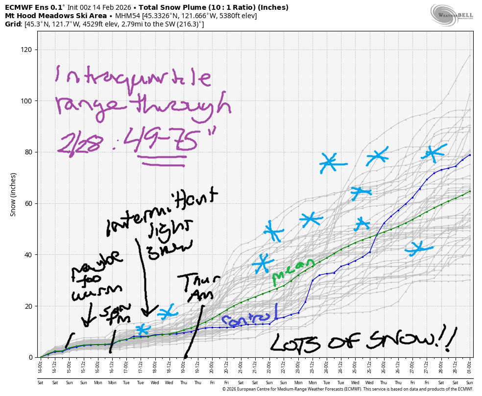
Hey skiers and snowboarders! Winter has finally arrived, and while it didn’t arrive with a huge dump, the pattern looks good for snow through the end of the month with the possible exception of a marginally cold system this evening into tomorrow. The intraquartile range for snowfall through next Friday is 13-26”. Through 2/28, it’s 49.75”-75”!
Short term Mt Hood snow forecast
Saturday starts mostly cloudy on Mt Hood with 4” new snow on the ground and packed powder, red Nordic wax, conditions. A system moves up from the south this afternoon and brings some snow. Depending on where the heaviest band of moisture sets up, we’ll see 0.1” to 0.5” water equivalent starting late morning and finishing tomorrow morning with the heaviest precip overnight. This gives us 1-4” relatively dense new snow; the snow level will be 2500′ all day and as low as 1500′ tonight, but temps will be right near 32F all the way up to 5000′. Wind will be W 20-30 this morning. S 5-10 this afternoon, NE 10 this evening, and WNW 15-20 overnight.
Sunday will be cloudy with a few flurries during the day. Up to an inch of new snow is forecast Sunday night. The snow level will be near 4000′ all day and all night. Wind: WSW 15-20 in the morning becoming SW 10-15 in the afternoon and holding overnight.
Extended Mt Hood Snow Forecast
A stronger cold front arrives on Monday. The snow level plummets from 4000′ in the morning to 2500′ in the afternoon to below 1000′ overnight. About 0.3” to 0.4” water equivalent (WE) is forecast during the day for around 4” new snow. Up to 0.1” WE is forecast overnight for another inch of new. Wind: SW 10-15 early, SW 15-25 in the afternoon, and SW 10-20 after midnight. Light flurries with cold weather (snow level 1000′, temps low 20s) is the forecast Tuesday and Wednesday.
Heavier snowfall is forecast Thursday into Friday, and then on into the future. Models keep temps cool, and they keep the precipitation coming, all the way through the end of this month. Fingers crossed. As of this morning, models call for 49-75” through the end of February. We need it!
Was that helpful? I knew it was! Guess what? All of this crucial work – from your personal wind and snow reports to the invaluable TATAS updates – is made possible by my relentless efforts. Maintaining this labor of love isn’t easy. Each daily forecast takes hours. Website hosting, weather model access, and back-end admin work takes time and money. That’s where you come in.
YOUR CONTRIBUTION MAKES A DIFFERENCE
- SUPPORT ACCURATE, HYPER-LOCAL WEATHER FORECASTING
- ENABLE ACCESS FOR ALL, EVEN THOSE WITH LESS MEANS
- SUPPORT A COOL HUMAN WHO WORKS HARD SO YOU CAN PLAY
Take a moment to click one of the buttons below. Donate $19.99 or more (how much does this forecast enhance your life?) and get the email in your inbox. Whether it’s a renewing subscription (auto-renew) or a one-time donation, every contribution makes a real difference. Help me keep this labor of love alive, so we can all continue playing, commuting, and living in the Gorge with peace of mind and the best weather forecasts possible. Thank you!


Hood River, Oregon 97031


GORGE WIND FORECAST
If you’re still seeing yesterday’s and it’s after 9am, try opening this in an incognito window
SHORT-TERM gorge wind forecast
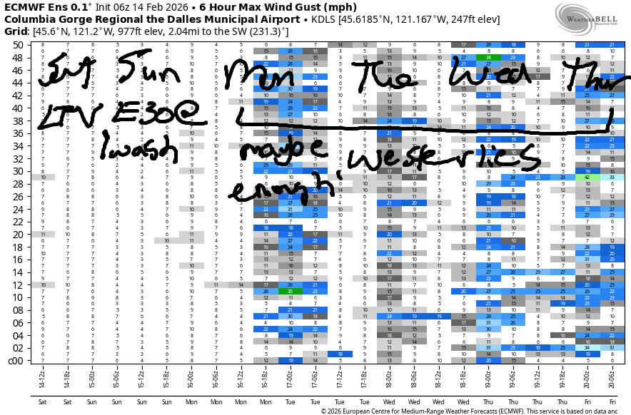
Hi friends! Easterlies stick around Saturday and Sunday. On Monday, there’s a chance of strong-enough westerlies. Tuesday through Thursday (maybe longer) brings westerlies of some sort, but probably not quite enough to get you on the river.
Saturday started with light onshore gradients and light/variable wind. As a system moves in this afternoon, the wind turns easterly at 15mph at both Iwash (Rooster) Rock and Stevenson. Expect light wind elsewhere. River flow over the last 24 hours was 146-184kcfs, river temp is 41.5F, and high temp forecast is 46F with clouds and rain.
RIVER FLOW FOR SITES BETWEEN AVERY (EAST OF THE DALLES) AND RUFUS: CLICK HERE FOR JOHN DAY DAM FLOW.
RIVER FLOW FOR SITES BETWEEN STEVENSON AND DOUG’S BEACH (WEST OF THE DALLES): CLICK HERE FOR THE DALLES DAM FLOW

LONGER-TERM gorge wind forecast
Sunday starts with E 30-35mph at Iwash and 20-25mph at Stevenson. The wind drops to 25mph in the afternoon at Iwash and 20mph at Stevenson. High temp: 47F and mostly cloudy. Monday is our best chance at west wind as a cold front swings through and a low sets up to the east. As of this morning, the GFS deterministic bring gusty 21-24mph from Stevenson to Hood River mid-morning followed by 24-27mph out east as the system moves inland. Fingers crossed! High temp: 44F.
Tuesday, Wednesday, and potentially other days deeper into the future bring westerlies of some sort. There’s no clear sign of a big day or even another day with Monday’s potential, but we’ll keep an eye on it! If nothing else, there’s a lot of snow coming for the mountains, so you’ll have something fun to do!
BARE BONES HOOD RIVER WEATHER FORECAST
Mostly cloudy this morning with drizzle this afternoon and night. Temps start in the mid 30s and rise to the mid 40s. Light and variable wind. 15% chance of rainbows. Sunday will be mostly cloudy with a few morning sprinkles. Temps start in the upper 30s and rise to the upper 40s. Light easterlies. 9% chance of rainbows. Monday will be rainy with a break in the afternoon. Temps start in the upper 30s and rise to the mid 40s. Moderate westerlies. 99% chance of rainbows.
TEMIRA’S AWESOME TRAVEL ADVISORY SERVICE
HYPERLOCAL WEATHER FORECAST FOR THE COLUMBIA GORGE
THE DALLES, HOOD RIVER, WHITE SALMON, TROUT LAKE, STEVENSON, CASCADE LOCKS, PARKDALE, ODELL, HUSUM, BZ, MILL A, WILLARD, GOLDENDALE, RUFUS, ARLINGTON, boardman
Good morning, neighbors! Cooler weather is in our future as are some snowflakes at our higher elevations. It’s possible we’ll see significant snow for higher elevations of the Gorge Thursday into Friday – we’ll take a closer look at the details emerge over the next few days… in the meantime…
Glenwood this morning
Saturday morning is standard-issue Gorge winter: cool and cloudy. Glenwood, thanks to cloud cover, only dropped to 37F last night. Red hat knitting continues. Roads around the region are going to be mostly bare and wet, but if you head up to Bennett Pass, there’s enough snow that ODOT declared “chains required”. Down lower, no ice, and also no !CE as far as anyone can tell.
Today’s Gorge weather forecast
Today’s weather offers up a few dry hours in the morning before a system slithers in from the south. South Wasco, being to the south, Sherman and Gilliam Counties, and Parkdale see drizzle first. By late afternoon, we’ll have drizzle all the way east to Idaho. Overnight, there’s some potential for wet snow down to 1000-1500′ under a narrow area of heavy precipitation, but this won’t apply to most of us. Max temps on Saturday: mid to upper 40s, warmest to the east. Wind: light and variable rising to E 15mph at Iwash (dick) Rock and Stevenson.
Sunday’s Gorge weather forecast
Sunday will be cloudy and mostly dry with an upper 30s start. Exception to “dry”: Parkdale, where a few sprinkles are possible. After 7pm, light rain arise form the southwest and extends eastward with intensity increasing after midnight. Sunday morning wind: 30-35mph at Iwash and 20-25mph at Stevenson. Afternoon: 20-25mph at both. Light wind elsewhere. Temps rise to the upper 40s in the lowlands.
Extended Gorge weather forecast
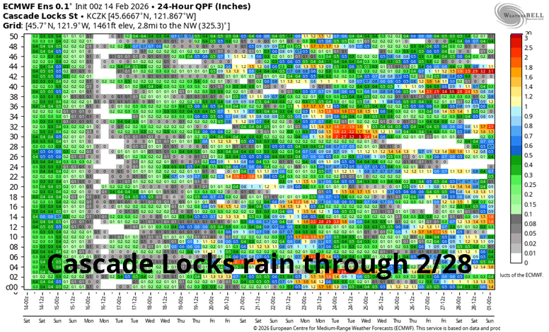
On Monday morning, we’ll have a soaker all the way east to Hermiston. This includes south Wasco and Sherman and Gilliam Counties. From mid-morning on, dry weather is forecast east of Mosier with wet weather to the west. A mid-afternoon break is followed by a colder system that drives the snow level below 1000′ overnight. Not much precip will be around, but a trace of snow is possible at higher elevations west of The Dalles. In a fun twist, this second system will turn the wind westerly at 20-25mph, which should 1) result in rainbows and 2) get the Wind Johnnies all jacked up. Mornign temps: upper 30s. Afternoon: mid 40s.
Tuesday and Wednesday look chilly with intermittent snow flurries or sprinkles. Not much snow accumulation is expected, if any. Icy roads are likely in the mornings and potentially in the shade in the afternoons. Depending on the timing of Thursday’s system, things could get messy. That would be the first real messiness of the 2025-2026 winter. How exciting! Safe travels. -TATAS
HEY! DON’T STOP READING! Is this community-focused forecast helpful to you? It sure is! It takes me a couple hours a day to write. Please join your friends and neighbors in contributing to keep it going. Venmo: @thegorgeismygym PayPal: twomirrors@gmail.com USPS: Temira / PO Box 841 / Hood River, Oregon 97031 You can test out the forecast subscription for a few days for free by signing up below. Easy! Do it!
JONES BEACH, SAUVIE ISLAND, & COAST FORECAST
ON WINTER VACATION UNLESS DESPERATELY NEEDED.
