

MT HOOD SNOW FORECAST

QR codes and links for end-of-season tips – thank you!!!
Cash/check: Temira – PO BOX 841 – Hood River, Oregon 97031


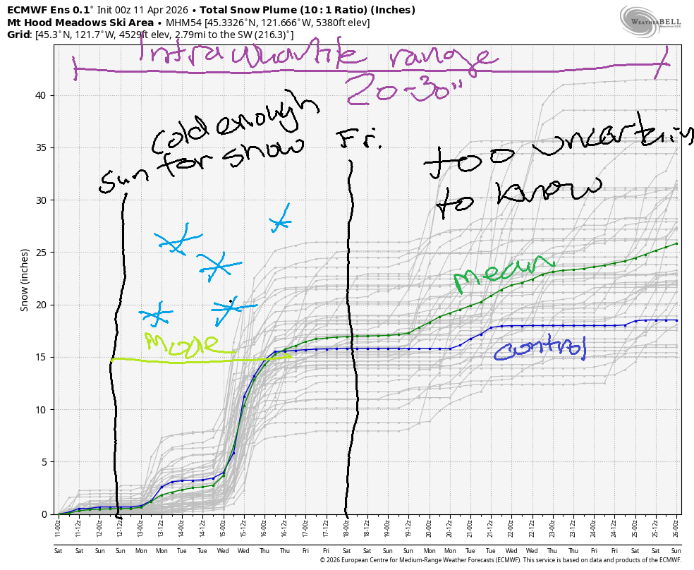
Hey skiers and snowboarders! It’s the final weekend for Meadows, but not for Timberline. But this isn’t the end of the pow – there’s a pow day on tap next Wednesday! You’ll just want to be careful where exactly you shred, because there’s not much base in many places. Between now and then: intermittent drizzly periods this weekend followed by light snow Monday and Tuesday. Intraquartile range for snowfall through April 25th is 20-30”.
Short term Mt Hood snow forecast
Saturday brings intermittent rain showers in the morning, partly cloudy sky and possible thunderstorms in the afternoon, and a few sprinkles overnight. The snow level will be 6500′ all day with temps at 5000′ in the upper 30s. It’s hard to say how much rain Mt Hood will receive – it all depends on where showers set up. Wind will be WSW 20-25 this morning, W 10-15 this afternoon, and light/variable overnight. Temps max out in the upper 30s. Snow surface: spring slush.
Intermittent showers are possible Sunday during the day with a bit of steadier mixed precip overnight. The snow level will be 6500′ early, 6000′ in the afternoon, and 5000′ overnight. Daytime precip quantity is uncertain due to the showery nature. Overnight, a more organized system brings up to 0.2” water equivalent that might give us an inch of snow at 5000′. Wind will be light/variable in the morning, NW 20-25 in the afternoon, and NW 30 after midnight.
Extended Mt Hood Snow Forecast
TLight snowfall is likely on Monday as the snow level falls from 5000′ to 2500′. Up to a couple inches of snow is possible with 0.2” WE. Wind will be NW 30-40 in the morning, W 30 in the afternoon, and W 25 overnight. That’s strong enough to impact at least some lifts.
Light snowfall continues Tuesday daytime (1-2”) with the snow level around 3000′ Overnight, heavy snowfall arrives with a system from the NW. The snow level falls as low as 2000′, and a foot of snow is likely. Windy, snowy conditions are forecast on Wednesday with several more inches of snow. Cool weather continues into Friday. Beyond that, conditions are warmer and dry for a couple of days before rain (probably) returns to finish off the weekend. Looking at this forecast, I’d say the last forecast of the season is likely to be after the Wednesday snowstorm. Have a great weekend on the snow!
Was that helpful? I knew it was! Guess what? All of this crucial work – from your personal wind and snow reports to the invaluable TATAS updates – is made possible by my relentless efforts. Maintaining this labor of love isn’t easy. Each daily forecast takes hours. Website hosting, weather model access, and back-end admin work takes time and money. That’s where you come in.
YOUR CONTRIBUTION MAKES A DIFFERENCE
- SUPPORT ACCURATE, HYPER-LOCAL WEATHER FORECASTING
- ENABLE ACCESS FOR ALL, EVEN THOSE WITH LESS MEANS
- SUPPORT A COOL HUMAN WHO WORKS HARD SO YOU CAN PLAY
Take a moment to click one of the buttons below. Donate $19.99 or more (how much does this forecast enhance your life?) and get the email in your inbox. Whether it’s a renewing subscription (auto-renew) or a one-time donation, every contribution makes a real difference. Help me keep this labor of love alive, so we can all continue playing, commuting, and living in the Gorge with peace of mind and the best weather forecasts possible. Thank you!


Hood River, Oregon 97031


GORGE WIND FORECAST
If you’re still seeing yesterday’s and it’s after 9am, try opening this in an incognito window
SHORT-TERM gorge wind forecast
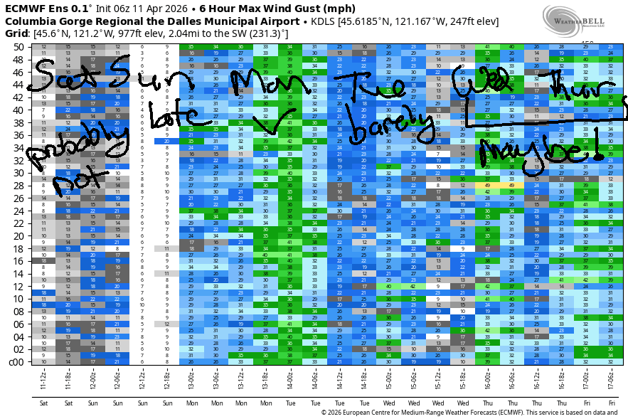
Hi friends! Unstable, active weather is forecast on Saturday with wraparound moisture on Sunday. This gives us gusty westerlies for most of the weekend. Late in the day Sunday, the setup turns more conducive to higher-quality wind, but it’s unclear if this will happen prior to dark. Better conditions are forecast on Monday out in the desert. Westerlies of some sort look to continue into the middle part of next week along with some rain and cooler temps.
Saturday started off with pressures of 29.72/29.64/29.63. A low pressure system was settled along the south coast, which leaves us in an unstable weather pattern. Early wind was 17-20 from Viento to Swell with 13-16 near Rowena and less than 10mph everywhere else. Midday wind falls below 10mph west of The Dalles before rising to 13-16mph from Stevenson to the Dalles mid-afternoon. We’ll see a bump to gusty 22-25mph from Avery to Hermiston mid-morning for a couple hours before the wind drops to 16-19mph in that zone this afternoon. Widespread surface-based instability will result in unreliable, up-and-down conditions that may respond in wild ways to any passing thunderstorms that develop. River flow over the last 24 hours was 142-289kcfs (179-195 at Rufus), river temp is 49.6F, and high temp forecast is 65F.
RIVER FLOW FOR SITES BETWEEN AVERY (EAST OF THE DALLES) AND RUFUS: CLICK HERE FOR JOHN DAY DAM FLOW.
RIVER FLOW FOR SITES BETWEEN STEVENSON AND DOUG’S BEACH (WEST OF THE DALLES): CLICK HERE FOR THE DALLES DAM FLOW

LONGER-TERM gorge wind forecast
On Sunday, a low moves inland late in the day and high pressure builds offshore behind it. Hopefully this happens before dark! Wind at dawn will be calm. By 2pm, we’ll see 12-15mph from Stevenson to Mosier. The wind slowly ramps up to gusty 19-22mph from Stevenson to Hood river with 24-27mph from Mosier to Rufus with 16-19mph east of Rufus. It’s possible we’ll see a late-day, gusty, strong session near the Hatch too. High temp: 62F with partly cloudy sky.
Offshore high pressure on Monday combines with a trough of cool air near western BC for solid west wind. Models suggest clouds will linger west of Mosier all day. Exact placement of those clouds will determine whether the Hatch lights up or not. Early wind will be gusty 17-20 from Stevenson to Mosier with 25-28 from Lyle to Arlington and 20-23 from Threemile to Hermiston. Afternoon wind rises to 28-32mph from Avery to Hermiston with 13-16mph (and fading more!) west of The Dalles. Again – cloud cover will determine the strongest, steadiest wind. Head east for best results. High temp: 56F in Hood River, 59F in The Dalles, and 64F out in the desert.
An approaching weather system on Tuesday gives us westerlies at gusty 19-22mph or so. Rain in the western Gorge Wednesday combines with relatively strong 850mb wind for a shot at 25-30mph east of The Dalles. Beyond that, uncertainty rises. In between then and now, there’s probably a day on the river for you. Have fun out there!

BARE BONES HOOD RIVER WEATHER FORECAST
Clouds and drizzle this morning. Partly cloudy later with a chance of thunder. Temps start in the low 50s and rise to the mid 60s. Light westerlies early. Moderate later. 57% chance of rainbows. Sunday looks cloudy with showers after 11am. Temps start in the mid 40s and rise to the low 60s. Calm wind early. Building westerlies that finish moderately strong. 31% chance of rainbows. Monday will be cloudy then partly cloudy. Temps start in the mid 40s and rise to the mid 50s. Moderate westerlies. No rainbows.
TEMIRA’S AWESOME TRAVEL ADVISORY SERVICE
HYPERLOCAL WEATHER FORECAST FOR THE COLUMBIA GORGE
THE DALLES, HOOD RIVER, WHITE SALMON, TROUT LAKE, STEVENSON, CASCADE LOCKS, PARKDALE, ODELL, HUSUM, BZ, MILL A, WILLARD, GOLDENDALE, RUFUS, ARLINGTON, boardman
Good morning, neighbors! Cloudy, breezy, unstable, mild, showery weather is on tap for the weekend. Tap that! Active weather is forecast much of next week with actual rain and mountain snow (and messy pass driving) Tuesday into Wednesday followed by chilly weather through the end of next week. We’ll be keeping a close eye on frost potential starting Wednesday morning…
Glenwood this morning
No frost this morning. As a matter of fact, the record high-low in Hood River is 48F, and HOXO was reading 50F as I was typing. We are on to something here! Even Glenwood only bottomed out at 50F this morning, which had all the bottoms clamoring to top.
Today’s Gorge weather forecast
Temps today rise to 65F (west), SIX-SEVEN (The Dalles), and 70F (The Desert). Drizzle is possible west of Mosier through late morning. If we see sunshine midday (likely), we could see thunderstorms and showers this afternoon especially in South Wasco, Parkdale, and Cascade Locks. Today’s wind starts with 15-20mph west of Mosier and light wind to the east. Afternoon brings 15mph west of The Dalles and 20-25mph from Avery to Hermiston.
Sunday’s Gorge weather forecast
High clouds of some sort stick around overnight with dewpoints > 32F most places. Sunday temps start in the 40-46F range with light wind. A low moving inland gives us some wraparound rain showers from late morning on especially east of The Dalles and especially in Wasco, Sherman, and Gilliam Counties. West wind builds slowly throughout the day and eventually rises to 20-23mph between Stevenson and the Arlington Triangle and the Roosevelt Regional Landfill. High temps range from 62-65F.
Extended Gorge weather forecast
Northwest flow on Monday morning gives us low clouds on the west side, sun to the east, and cooler temps. Given how windy it will be, frost is unlikely except maybe in Glenwood, but we’ll revisit this tomorrow. Monday afternoon sees temps max out at 54F (west) 59F (the Dalles) and 64F (the Desert). This onshore temp gradient brings west wind: 15mph west of The Dalles (or maybe west of Lyle0 and 25-35mph east of the low clouds all the way out to Hermiston.
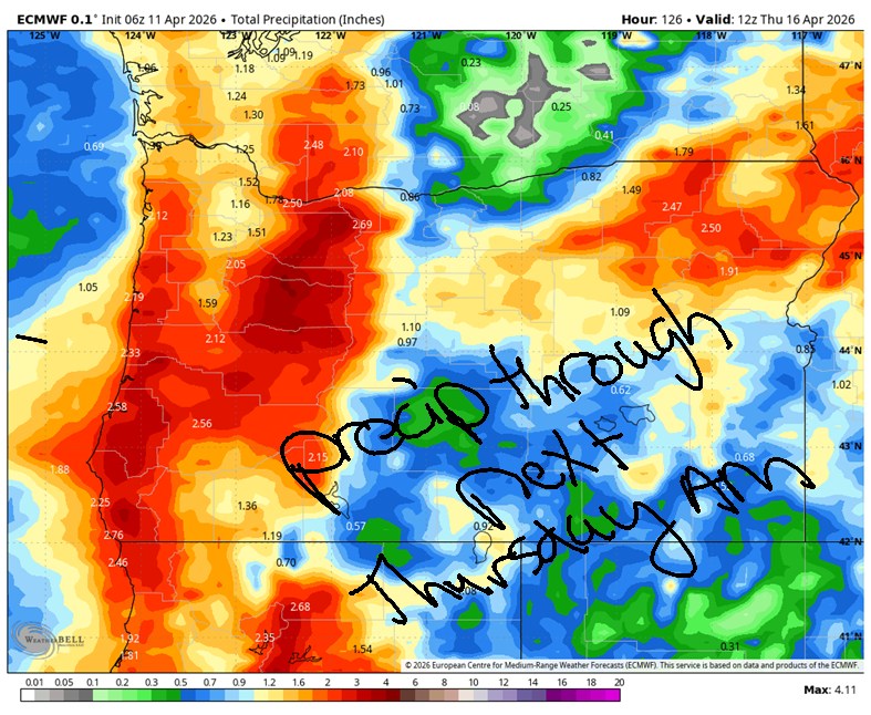
Light rain returns Tuesday morning and amps up to heavy rain west of Lyle Tuesday night. With temps at 850mb (~5000′) falling as low as -4C, we’ll see up to a foot of snow on the passes by Wednesday morning. See the rain map for rain totals in the Gorge. Cool weather sticks around through the end of the week with highs in the 50s. Wednesday morning will likely be too windy for frost, but we’ll want to keep a close eye on Thursday and Friday. More on that as we get closer. Safe travels. -TATAS
HEY! DON’T STOP READING! Is this community-focused forecast helpful to you? It sure is! It takes me a couple hours a day to write. Please join your friends and neighbors in contributing to keep it going. Venmo: @thegorgeismygym PayPal: twomirrors@gmail.com USPS: Temira / PO Box 841 / Hood River, Oregon 97031 You can test out the forecast subscription for a few days for free by signing up below. Easy! Do it!
JONES BEACH, SAUVIE ISLAND, & COAST FORECAST
ON WINTER VACATION UNLESS DESPERATELY NEEDED.

Leave a Reply