

MT HOOD SNOW FORECAST

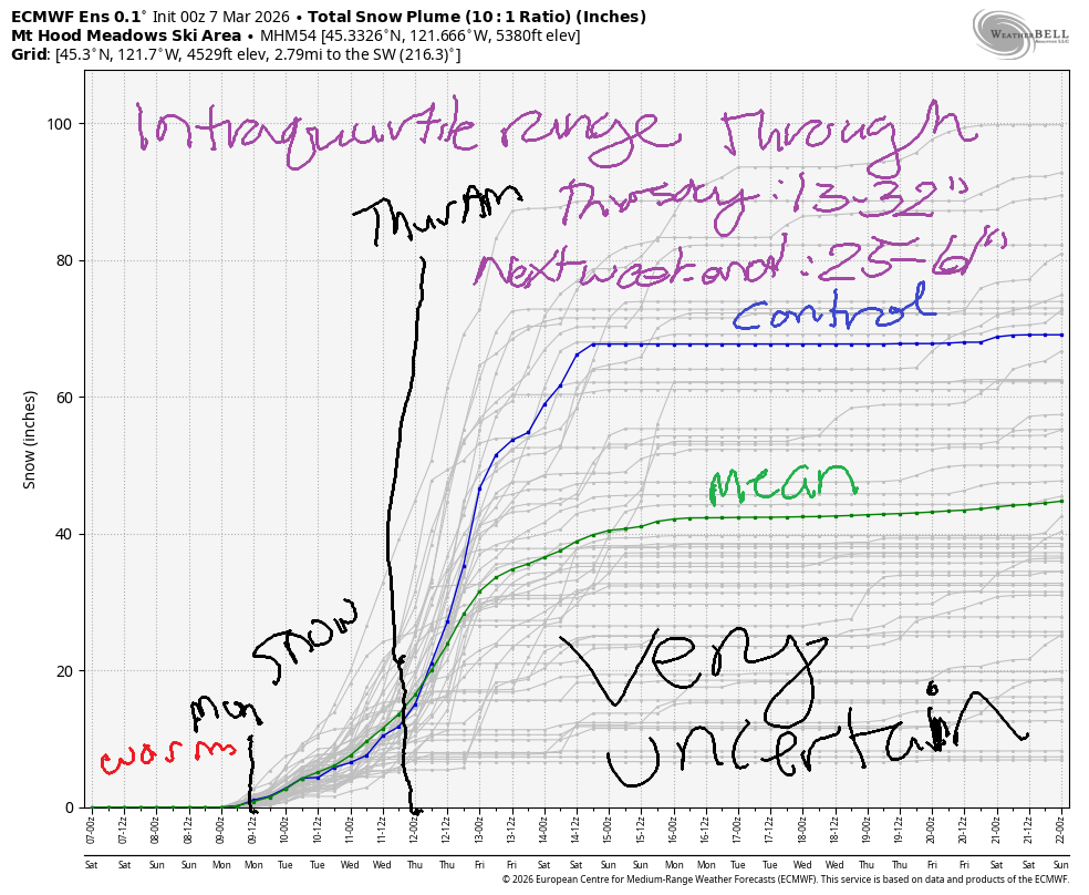
Hey skiers and snowboarders! It’s a windy one on Mt Hood this morning, and wind sticks around in the forecast today. With a forecast of NW 30 on the sounding model, we’re tip-toeing around what lifts can handle. Fingers crossed! Looking ahead, we have a cold front taking the snow level back down to the snow zone on Sunday followed by snow for the early part of next week. Starting early Thursday, massive uncertainty is present in the models; it’s really impossible for me to give you anything more than a broad-brush forecast for this upcoming week. That said, the intraquartile range through early Thursday for snowfall is 13-32”. Through next weekend, it’s 25-61”. See why I can’t predict it?!?!
Before I dive in – today is Ski ALS at Meadows. My dear friend Dick was recently diagnosed with ALS, and my friends and I are raising funds for ALS Northwest. If you’d be so kind as to make a donation – even a few $$$ is awesome – I’d so appreciate it. ALS Northwest does all sorts of awesome services for folks (provides counseling, equipment, etc), and your money will be put to good use. Thank you so much for contributing!
Short term Mt Hood snow forecast
Saturday’s Mt. Hood snow forecast contains no snow, but it does contain clouds and wind! High wind may affect lift ops. As I’m typing this, I’m waiting to hear back from my contacts, so you’ll wanna check resort websites for updates throughout the day. The snow level today will be 12,000′ all day and will fall to 10,000′ overnight. It’s possible we’ll see a little drizzle today, but not certain. Temps max out in the 40s. We’ll have NW wind at 30mph all day, which is problematic for lifts. Overnight, the wind turns to W 35, which is less problematic.
On Sunday, we’re expecting a cold front and strong wind. This will drag in some precipitation, likely rain at first and then wet snow. We start the day sunny and quickly add some clouds, but it’s unclear how deep the clouds will be. The snow level will be 10,000′ early, 6000′ mid-morning, 5000′ in the afternoon, and around 1000′ overnight. Up to 0.2” rain s possible during the day followed by 0.1” water equivalent (WE) snow overnight. That gives us an inch or so of snow. Wind will be W 35-40 all day long and will drop to W 30 overnight.
Extended Mt Hood Snow Forecast
Light snowfall is forecast on Monday. The snow level starts around 1000′, rises to 1500′ midday, and drops as low as 500′ after midnight. There’s some uncertainty about how much snow we’ll see – could be an inch, could be 5”. Wind will be W 20-30 all day long. Model agreement falls apart on Tuesday – it should be cold, but it’s unclear how much snow we’ll see. Potentially a couple inches Tuesday and Wednesday.
As we head into the Wednesday-Thursday period, some ensemble members drag an atmospheric river inland and combine it with cold air. Some do not. We could see massive snow. We could see heavy rain. We could see neither or even a combo of the two. With this much uncertainty, I can’t give you a forecast, so I’ll stop now. Have a great day on the slopes today!
Was that helpful? I knew it was! Guess what? All of this crucial work – from your personal wind and snow reports to the invaluable TATAS updates – is made possible by my relentless efforts. Maintaining this labor of love isn’t easy. Each daily forecast takes hours. Website hosting, weather model access, and back-end admin work takes time and money. That’s where you come in.
YOUR CONTRIBUTION MAKES A DIFFERENCE
- SUPPORT ACCURATE, HYPER-LOCAL WEATHER FORECASTING
- ENABLE ACCESS FOR ALL, EVEN THOSE WITH LESS MEANS
- SUPPORT A COOL HUMAN WHO WORKS HARD SO YOU CAN PLAY
Take a moment to click one of the buttons below. Donate $19.99 or more (how much does this forecast enhance your life?) and get the email in your inbox. Whether it’s a renewing subscription (auto-renew) or a one-time donation, every contribution makes a real difference. Help me keep this labor of love alive, so we can all continue playing, commuting, and living in the Gorge with peace of mind and the best weather forecasts possible. Thank you!


Hood River, Oregon 97031


GORGE WIND FORECAST
If you’re still seeing yesterday’s and it’s after 9am, try opening this in an incognito window
SHORT-TERM gorge wind forecast
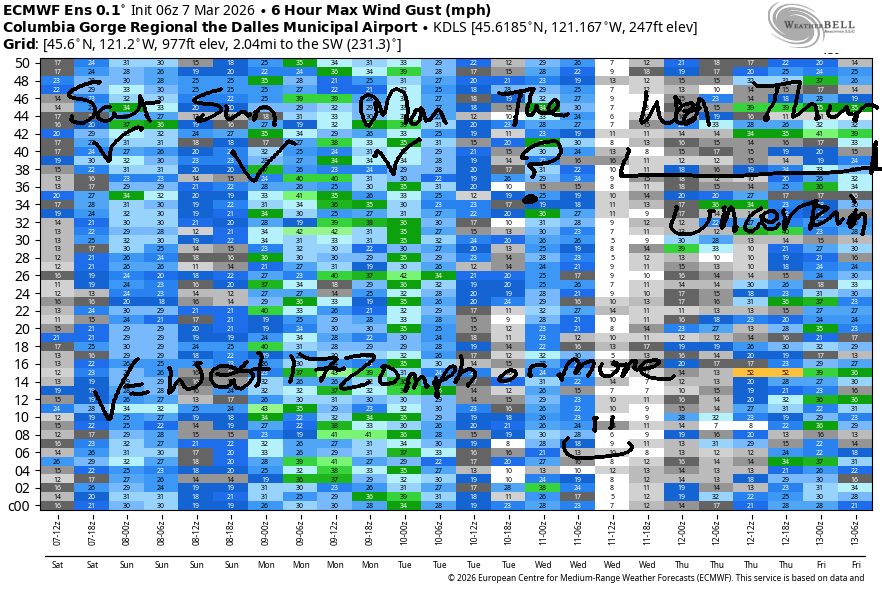
Hi friends! A windy day is on tap for Saturday as strong offshore high pressure (1036mb!) combines with warm temps inland for the winter version of a Classic Gorge Setup. Westerlies continue into next week, although he details are unclear.
Saturday started with pressures of 30.39/30.28/30.18 for gradients of 0.11/0.10. Add in low clouds to the west and strong offshore high pressure, and we’re dialed in for a decent day. At dawn, the Hatch was reading 28mph! I was going to say 24-27mph this morning from Viento to the Hatch and also at Mosier, but maybe I should say 25-28mph. Out east, we’ll have 20-25mph this morning. Afternoon wind drops to 17-20mph west of Rowena and rises to 29-32mph from Rowena to Threemile. It’s possible we could beat that by a few mph; this is a good setup! River flow over the last 24 hours was 135-189kcfs (149-181kcfs at Rufus), river temp is 42.8F, and high temp forecast is 59F in Hood River and 69F way out east in the desert. There’s your bonus thermal gradient!
RIVER FLOW FOR SITES BETWEEN AVERY (EAST OF THE DALLES) AND RUFUS: CLICK HERE FOR JOHN DAY DAM FLOW.
RIVER FLOW FOR SITES BETWEEN STEVENSON AND DOUG’S BEACH (WEST OF THE DALLES): CLICK HERE FOR THE DALLES DAM FLOW

LONGER-TERM gorge wind forecast
Sunday sees a weak system move in. The day starts with 18-21mph from Viento to the Hatch with similar wind at Rufus and less wind anywhere not mentioned. Afternoon wind falls to 13-16mph west of Avery and rises to 30mph or so from Avery to Hermiston. As rain pushes inland in the afternoon, the wind will shift farther east. High temp: 55F in Hood River and 65F out in the desert.
On Monday morning, we’ll have westerlies at 10-13mph all through the Gorge. 15-18mph wind is possible west of The Dalles in the afternoon. If you head out east, you’ll find 25-28mph, which is just barely enough given that those sensors read high compared to the Swell sensor. Somewhat lesser westerlies are possible on Tuesday. Uncertainty skyrockets on Wednesday, but there remains a chance of big west wind late Wednesday into Thursday. Hopefully some clarity will enter into the forecast soon so we can plan for this! Be safe out there today, and have lots of fun!
Sunday looks like another 30mph day out east. Models are all over the place for Monday’s forecast, but there’s a decent chance the strong westerlies will stick around. All that should be enough to get you excited. Hope to see you out there! Stay warm and safe!

BARE BONES HOOD RIVER WEATHER FORECAST
Partly cloudy sky today. Temps start in the low 50s (RECORD HIGH LOW) and rise to the upper 50s. Strong westerlies. 1% chance of rainbows. Sunday will be intermittently drizzly. Temps start in the upper 40s and rise to the mid 50s. Moderate westerlies. 96% chance of rainbows. Monday will be partly cloudy. Temps start in the mid 30s and rise to the upper 40s. Light westerlies. 0.5% chance of rainbows.
TEMIRA’S AWESOME TRAVEL ADVISORY SERVICE
HYPERLOCAL WEATHER FORECAST FOR THE COLUMBIA GORGE
THE DALLES, HOOD RIVER, WHITE SALMON, TROUT LAKE, STEVENSON, CASCADE LOCKS, PARKDALE, ODELL, HUSUM, BZ, MILL A, WILLARD, GOLDENDALE, RUFUS, ARLINGTON, boardman

Good morning neighbors! Today’s highlight is wind, enough wind for very happy Boardheads. Be happy for the Wind Johnnies! In other exciting news, we have almost 70 degrees out near Pasco today (if you drive out there to be warm, you can add CO2 to the air and make 70 degrees more likely) and a chance of low elevation snow this week. Anyway…. I’m supposed to be somewhere this morning, so I’m gonna be quick.
Glenwood this morning & Today’s Gorge weather forecast
Glenwood was 48 degrees this morning, and Hood River was 50 degrees. That’s record high-low territory for Hood River (47F is the record high-low). We won’t see a record high today, but it will be warm: upper 50s for the west, mid 60s for The Dalles, and upper 60s for the desert. The west side holds on to low clouds, and the east side turns sunny today. West wind will be 25-35mph this morning west of Hood River and 20mph this afternoon. In the desert, you’ll find 20-25mph this morning and 30mph this afternoon.
Other news this morning: no !Ce on the roads. It appears that the Oregon courts requiring !CE to follow the Constitution by having warrants before detaining people has reduced their presence on the roads, at least out here.
Sunday’s Gorge weather forecast
Breezy conditions continue tonight which keeps temps warm for Sunday morning. The day starts with low clouds in the west and mostly clear sky to the east with west wind at 15-20mph. Intermittent light drizzle is possible as far east as Hood River until 5pm, and then we’ll see drizzle as far east as Biggs (and south Wasco) in the evening. Afternoon wind rises to 30mph east of The Dalles and drops to 15mph west of The Dalles. Temps rise to the mid 50s (west), 60F (The Dalles) and 65F (The Desert).
Monday’s Gorge weather forecast & the extended Gorge weather forecast
A cold front Sunday night drives temps way down by Monday morning. It’s possible we could see some snow flurries in the wee hours of Monday above 1000′, but actual accumulation is unlikely. It’s also possible we could see icy roads in select not-windy areas thanks to radiational cooling, but road surface temps may be too warm for that. For Tuesday and Wednesday, we’ll see intermittent showers and cool temps with moderate west wind. Beyond Wednesday, there’s massive uncertainty in the models – anything from a big atmospheric river to snow to dry weather, so I give up and am going to finish up now. We’ll revisit this tomorrow. Between now and then, go ahead and plant your pepper seeds. Safe travels. Happy gardening. -TATAS
HEY! DON’T STOP READING! Is this community-focused forecast helpful to you? It sure is! It takes me a couple hours a day to write. Please join your friends and neighbors in contributing to keep it going. Venmo: @thegorgeismygym PayPal: twomirrors@gmail.com USPS: Temira / PO Box 841 / Hood River, Oregon 97031 You can test out the forecast subscription for a few days for free by signing up below. Easy! Do it!
JONES BEACH, SAUVIE ISLAND, & COAST FORECAST
ON WINTER VACATION UNLESS DESPERATELY NEEDED.

Leave a Reply