

MT HOOD SNOW FORECAST

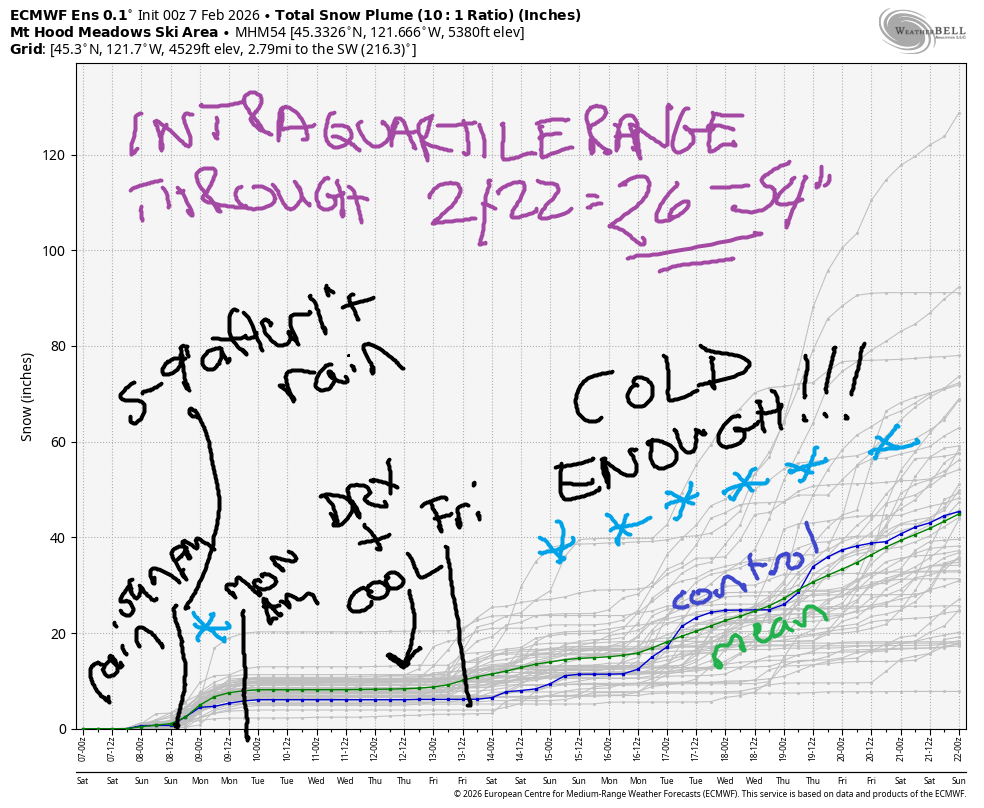
Hey skiers and snowboarders! Saturday’s not going to be a pretty one on the slopes – rain is incoming – but the weather is looking up starting tonight. We’re expecting some snow between now and Monday. Following that: a cool, dry week. Models bring snowfall into the picture again late next week or next weekend, with good news in the long-range forecast. Intraquartile range for snowfall through Monday is 5-9”. Intraquartile range through 2/22 is 26-54”. You could vote for the outlier member of the ECMWF ensemble which gives us about 130”, but that’s about as likely as the low-end outlier which only has 10”!
Short term Mt Hood snow forecast
So, Saturday starts off cloudy. Mist or drizzle arrives mid to late morning, but rain really doesn’t get going until the afternoon. It’ll switch to snow mid-to late evening. The snow level will be 7000′ during the day, 5500′ in the evening, and 4000′ after midnight. About 0.8” rain is forecast. That’s followed 0.2” to 0.4” water equivalent (WE) that falls as wet snow. Call it 1-3” at 5000′. Wind Saturday will be SW 20-30 early, SW 30-50 mid-afternoon, W 25 in the evening, and NW 15-20 after midnight.
Light to moderate snowfall continues on Sunday. The snow level will be 4000′ early, 4500′ mid-morning, 4000′ in the afternoon, and 2000′ after midnight. Models have quite a bit of range in total precip; we’re looking at anywhere between 0.4” and over an inch of water equivalent (WE). Most likely scenario is half a foot of dense, heavy new snow, but we could get lucky and get a lot more if the front lines up and stalls just right. Please vote for “lucky”. Wind will be NW 15-20 in the morning, under 10mph for most of the day, and NW 20-25 after midnight.
Extended Mt Hood Snow Forecast
Monday starts with light snowfall and turns clear by afternoon. The snow level will be 2000′ in the morning, 3000′ under clear sky in the afternoon, and the free air freezing level will be around 2000′ after midnight. We’ll pick up about 0.2” WE before the sky clears for 2-3” relatively dry snow. Wind will be NW 25-30 in the morning, NW 10-15 in the afternoon, and ESE 15 after midnight.
Tuesday and Wednesday look sunny with variable wind under 10mph. On Tuesday, the freezing level will be around 2000′. On Wednesday, it will rise to 4000′. Thursday also looks sunny and sub-freezing at 5000′. It’s possible snow will return starting on Friday. Better chances for significant snowfall arrive on 2/16 and continue into the long-range forecast. Fingers crossed!
Was that helpful? I knew it was! Guess what? All of this crucial work – from your personal wind and snow reports to the invaluable TATAS updates – is made possible by my relentless efforts. Maintaining this labor of love isn’t easy. Each daily forecast takes hours. Website hosting, weather model access, and back-end admin work takes time and money. That’s where you come in.
YOUR CONTRIBUTION MAKES A DIFFERENCE
- SUPPORT ACCURATE, HYPER-LOCAL WEATHER FORECASTING
- ENABLE ACCESS FOR ALL, EVEN THOSE WITH LESS MEANS
- SUPPORT A COOL HUMAN WHO WORKS HARD SO YOU CAN PLAY
Take a moment to click one of the buttons below. Donate $19.99 or more (how much does this forecast enhance your life?) and get the email in your inbox. Whether it’s a renewing subscription (auto-renew) or a one-time donation, every contribution makes a real difference. Help me keep this labor of love alive, so we can all continue playing, commuting, and living in the Gorge with peace of mind and the best weather forecasts possible. Thank you!


Hood River, Oregon 97031


GORGE WIND FORECAST
If you’re still seeing yesterday’s and it’s after 9am, try opening this in an incognito window
SHORT-TERM gorge wind forecast
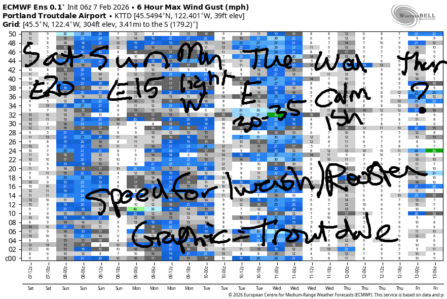
Hi friends! Not much happening in the next five days or so – strongest day looks like next Tuesday when easterlies may rise to 30-35mph at Iwash/Rooster Rock. Saturday starts off with pressures of 30.16/30.24/30.22 and easterlies under 20mph in the usual spots. By midday, the wind goes calm. It turns light westerly overnight before turning easterly again on Sunday. River flow over the last 24 hours was 147-187kcfs, river temp is 41.0F, and high temp forecast is 48F under cloudy sky with rain from mid-morning on.
Sunday starts with E 15mph at both Iwash/Rooster and Stevenson. By late morning, the wind turns calm. High temp: 51F with rain all day long.
RIVER FLOW FOR SITES BETWEEN AVERY (EAST OF THE DALLES) AND RUFUS: CLICK HERE FOR JOHN DAY DAM FLOW.
RIVER FLOW FOR SITES BETWEEN STEVENSON AND DOUG’S BEACH (WEST OF THE DALLES): CLICK HERE FOR THE DALLES DAM FLOW

LONGER-TERM gorge wind forecast
On Monday, we’ll have west wind as a weak cold front swings through. Don’t expect much – for now, models have 7-10mph west of The Dalles with 13-16mph from Avery to Arlington. High temp: 49F with clouds to the west and sun to the easy.
High pressure rebuilds inland on Tuesday and gives us a shot at 30-35mph east wind on Tuesday. High pressure over the region on Wednesday turns the wind calm. That’s it for today. If you’re going to play in the river, dress warmly, have an emergency plan, and keep an eye on your buddies!
BARE BONES HOOD RIVER WEATHER FORECAST
Clouds this morning. Rain this afternoon and tonight. Temps start in the low 40s and rise to the upper 40s. Light easterlies. 5% chance of rainbows. Sunday will be rainy all day. Temps start in the mid 40s and rise to the low 50s. Calm wind. 1% chance of rainbows. Monday will be showery. Temps start near 40 and rise to the upper 40s. Light westerlies. 98% chance of rainbows.
TEMIRA’S AWESOME TRAVEL ADVISORY SERVICE
HYPERLOCAL WEATHER FORECAST FOR THE COLUMBIA GORGE
THE DALLES, HOOD RIVER, WHITE SALMON, TROUT LAKE, STEVENSON, CASCADE LOCKS, PARKDALE, ODELL, HUSUM, BZ, MILL A, WILLARD, GOLDENDALE, RUFUS, ARLINGTON, boardman
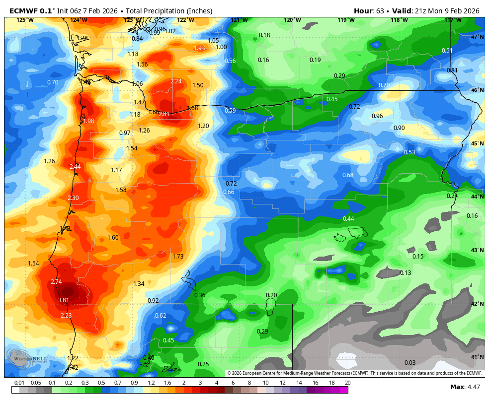
Good morning, neighbors! Actual f’ing rain is headed this way today!!! Holy shit!!! Rain! Even more rain arrives on Sunday (see image for total precip through Monday) and extends all the way out into the desert thanks to a short-lived, but robust, atmospheric river. Up in the mountains, some actual SNOW will fall!
Glenwood this morning
This is all so exciting that I almost forgot to check in with Glenwood. But I remembered eventually Glenwood was 35 degrees this morning, and everyone is sad because it’s yet another above-freezing day. The only place close to freezing is Dufur, where thermometers are reading 32-33F. It’s so warm that there doesn’t appear to be any !CE on the roads, and there probably isn’t any frost either. I did find a little frost on the road near Gumjuwac yesterday…
Today’s Gorge weather forecast
As I said before, we’re expecting RAIN today. It arrives in Cascade Locks by noon, in Rowena by 2pm, and extends all the way to the Tri-Cities as very light mist or drizzle by 5pm. If you’re driving to/from the metro area, expect heavy rain west of Viento from 1pm to 7pm. That’ll be heavy enough for hydroplaning, so be careful. Drizzle continues pretty much all night long all the way out into the desert. Sherman County’s drizzle starts around 4pm, and south Wasco County finally overcomes the rain shadow late evening. High temps today in the lowlands: 48-50F. Wind will be E 15 in the morning in the usual spots, calm midday, and W 10-15 west of Hood River this afternoon.
Overnight: rain.
Sunday’s Gorge weather forecast
Sunday morning: rain and drizzle, on and off, heaviest to the south, and definitely wet in south Wasco and Sherman Counties. Rain intensity picks up after 11am with moderate to heavy rain likely all the way east into Idaho after 1pm and continuing until 7pm. PERFECT TIMING – PERFECT WEATHER FOR WATCHING THE SEAHAWKS! After 10pm, the rain starts to taper off. It’s worth mentioning that the snow level will be 4000′ during the day Sunday and 2500′ overnight. Passes will be snowy. Be prepared for winter driving conditions. Sunday wind: E 15mph in the morning in the usual spots and calm in the afternoon. High temp: 49-51F in the lowlands.
Extended Gorge weather forecast
Monday sees intermittent morning drizzle as far east as Hood River with a dry, mostly clear afternoon. Morning temp: 40ish with a few flurries possible above 2000′. Afternoon 49F to the west, 52F in The Dalles, and 54F way out east in the desert. Wind will be light westerly all day which is likely to fire off some rainbows.
Dry weather returns Tuesday and sticks around through at least Thursday. It appears the (insert string of profanity) Nothing cloud will return on Tuesday and stick around. I’m crying. Thank goodness it will be sunny above it. Safe travels. -TATAS
HEY! DON’T STOP READING! Is this community-focused forecast helpful to you? It sure is! It takes me a couple hours a day to write. Please join your friends and neighbors in contributing to keep it going. Venmo: @thegorgeismygym PayPal: twomirrors@gmail.com USPS: Temira / PO Box 841 / Hood River, Oregon 97031 You can test out the forecast subscription for a few days for free by signing up below. Easy! Do it!
JONES BEACH, SAUVIE ISLAND, & COAST FORECAST
ON WINTER VACATION UNLESS DESPERATELY NEEDED.
