| Your favorite launch | dawn patrol |
morning max | afternoon max | executive session |
|
|---|---|---|---|---|---|
| Iwash (Rooster) Rock | do your | buns | attract | lightning? | |
| Stevenson | E10 | E15 | W30 | W30 | |
| Viento | E10 | E15 | W30++ | W30++ | |
| Swell-Hood River | E10 | E15 | W30+ | W30 | |
| Lyle to Doug’s | LTE | E5-10 | W30-40 | W30 | |
| Rufus, etc: 100-173kcfs flow | LTE | E5-10 | W35-45 | W30 | |
| Roosevelt & Arlington | LTE | E5-10 | W35-45 | W30 | |
| River flow last 24 hours: 100-173kcfskcfs | =River temp: 70.88F | HR High temp: 89?F | |||
Gorge Wind Forecast
Hi friends! Quite the exciting day is on tap today. It’s a hard one to predict the wind accurately because thunderstorms are involved. Safety should be foremost today. Speaking of, if you see aircraft scooping water (they scoop between Memaloose Island and Lyle), go elsewhere. You don’t want to interfere with fire suppression efforts, and you definitely don’t want a run-in with the Coast Guard. Beyond today, the scooping will continue but the wind will be rather unreliable. We’ll dig more into that in a little bit. Oh, before I forget – there’s a swap meet at Windance on Sunday morning!
Is this feeling helpful? If so, go ahead and make a contribution using Paypal to support it. Send $19.99 or more, and I’ll send the forecast to your inbox for a year.
For Saturday, we start with offshore pressure gradients of 0.03 and 0.03. The wind was E 10ish at Stevenson and E 15ish at Viento (which reads high). Peak easterlies will be mid-morning with 15mph near Stevenson and Viento. Not Iwash (Rooster Rock). Nope. Not today. Sometime mid-afternoon, in response to a deep, powerful low swinging inland, the wind turns onshore. Chaos ensues. Given the massive instability and high likelihood of thunderstorms, it’s nearly impossible to say what the wind will do. I can tell you what the gradient forecast says: Around 2pm, the wind rises to gusty 22-26 (huge gusts!) from Stevenson to Mosier with E 5-10 to the east. In the 5-8pm time period, it ramps up to 30-40mph all the way from Stevenson to Rufus, maybe Arlington. Even stronger wind is possible out in the desert with massive gusts. BUT: in this same time period, dramatic destabilization happens. This equates to the wind doing goodness-knows-what. We’re also likely to see lightning, hail, downpours, and massive outflow wind gusts. Keep an eye on the radar before you get on the river and have an exit strategy. It’s worth noting that instability will be most pronounced west of The Dalles. Thunderstorms are still likely to the east, but may not be as severe. This is not the day to attempt a long and exit-free downwinder like Blalock to Arlington or Silos to Rufus. Keep it short and sweet. River flow over the last 24 hours was 100-173kcfs, river temp is 70.88F, and high temp forecast is 89F for Hood River, but we’re unlikely to hit that with the increasing clouds.
Things settle down on Sunday. We’ll have a stable marine layer to the west and sun to the east. We’ll also have a low offshore, which usually leads to up-and-down wind. The wind starts at 5-10mph west of Avery and 18-22 from Celilo to Arlington. Afternoon wind only rises to 10mph or so west of Lyle. It slowly builds to gusty 17-20 from Lyle to Arlington around noon and gusty 20-23 from Lyle to Arlington in the afternoon. High temp: 76F for Hood River and 83F for Arlington.
Writing the complete forecast takes me 1-2 hours a day. If it saves you time, gas money, or helps you plan your life, please consider contributing.

Low pressure lingers off the coast on Monday. The days starts light, less than 10mph, all through the Gorge. Models hint at midday thermals form Stevenson to Doug’s in the 16-19 range. Afternoon could bring gusty 21-25 from Mosier to Avery or Rufus. This is definitely the kind of setup that favors the Rowena stretch of the river, and you can definitely expect it to be gusty. High temp: 76F for Hood River and 83F out east.
That was helpful in planning your life, wasn’t it? Go ahead and subscribe to the forecast using the fancy auto-renew option. Don’t like electronic payment? No problem! You can send a check or cash to: Temira / PO Box 841 / Hood River, Oregon, 97031. Thank you so much for supporting the forecast. I’m glad you find it helpful, and I appreciate your kindness in supporting the work I’m doing!

Extended: low pressure lingers off the coast and keeps wind speeds well below nuking but probably in the “strong enough” range for the rest of the week. Temps should stay below 80 degrees, meaning you can add in some dryland activities to your water sports. Have a great day on the river today. Be safe out there, and take the instability and lightning potential seriously.

Jones, Sauvie Island, Oregon Coast
North/Central/South coast, waves (swell forecast provided by NWS). Wind forecast for the afternoon (unless it’s a storm on the coast, in which case that’s peak wind during the day). Wind direction N (coast/Sauvie Island) and W (Jones) unless otherwise noted. Saturday: N15/LTN/LTN, NW swell 3′ at 8 seconds. Sunday: S20/S10-15/S10, NW 3′ @ 8 and SW 3′ @ 14. Monday: SW15/W10/LTV, NW 3′ @ 8. Jones Saturday: 21-24 (watch out for thunderstorms). Sunday: LTV. Monday: 10-13. Sauvie Island Saturday: 15-18 briefly then S 10 (watch for thunderstorms). Sunday: SW 10-15. Monday: N 10-13.
Alan’s Sauvie Island Wind Sensor
Mt. Hood Weather Forecast
I’m tired. It’s on vacation.
Very basic Hood River weather forecast. Don’t plan your life around this. You really should read Temira’s Awesome Travel Advisory Service on Facebook
Partly cloudy sky this morning adds more clouds as the day goes on. Then lots of clouds and thunderstorms! Temps start in the mid 50s and are supposed to rise to the upper 80s, but it’s pretty cloudy already. High temp: ??. Calm wind early. Super-strong west wind briefly late. 17% chance of rainbows. Sunday will be partly cloudy then mostly clear. Temps start in the upper 50s and rise to the mid 70s. Moderate westerlies. No rainbows. Monday will be partly high overcast. Temps start in the mid 50s and rise to the mid 70s. Light wind early. Moderate westerlies later. No rainbows.
Local-ish Events
Please let me know of outdoor-related local-ish events. If you don’t tell me, I don’t know!
There’s a weekly social for Wind Johnnies (The Gorge Wind Social) at Ferment Brewing every 3rd Monday this summer. There’s a free community paddle at Wylde Wind and Water every Saturday at 10am (gear provided, all ages). They also have a free community wingfoil orientation every Thursday at 5:30pm at the Hook (all ages, gear provided). Northwave and GoFoil sponsor wingfoil races on Tuesday evenings.
The Columbia Gorge Junior Kayak Club offers free roll sessions (gear provided) for kids at the Hood River Pool every other Tuesday from 5:30 to 7pm. Visit their website for more deets: https://www.columbiagorgejuniorkayakclub.org/. Amayah’s offers a free meal every First Thursday from 1pm to 4pm. Regular weekly events:. NK Studio’s by-donation Tuesday morning yoga class is back. Ferment’s Tuesday night 4-mile walk/run is at 6pm. There’s meditation with monks at 5:15pm (an hour) and 6:30pm (30 minutes plus a talk) at Yoga Samadhi in White Salmon. Columbia Gorge Tri Club meets at Mayer State Park at 6pm Tuesdays. At 7:15am on Wednesdays, there’s a run from the White Salmon Bakery. At 7am on Friday morning, there’s a run from Pine Street Bakery. On Fridays at 2:30pm, there’s a free meditation and stretching class at Yoga Samadhi. On Saturday at 9am, there’s a by-donation outdoor group fitness on the 2rd floor deck about Ferment Brewing.
Cycling
All vehicles on HR County forest roads need a gallon of water and a shovel. Fire or fire danger closures: Whoopdee, Underwood, Hospital Hill, most of Post Canyon, Gorge 400, trails around Mt. Adams, the Twin Tunnels trail between Hood River and Mosier (really, people, stop riding it – you’re disrupting fire operations according to the crews). Open: 44 Road Trails, Ape Canyon, Lewis River, Falls Creek, Columbia Hills, Gunsight, Boulder Lakes, Siouxon, Sandy Ridge. Remember that E-bikes are not allowed on USFS non-moto trails. They are allowed on moto trails.
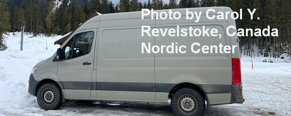
Sprinter Van of the Week!
 Click here for the Sprinter Van map of the world!!!
Have an awesome day!


