


Thank you for using this forecast. Like it? Find it useful? Support it (and me!) by sending some cash my way. What’s it cost to support me and get the email version? Not $99 a year. Nope. Not $49. Just $19.99 or more gets you a year. People are added to this list on Thursday and Sunday. My day job is crisis mental health, and I don’t have time on other days. Thanks for your patience! Click below to contribute. Thank you!!
 |
|
 |
The Forecast
| Your favorite beach | Dawn Patrol |
9am- 11:30a |
11:30a- 3pm |
3pm- dusk |
|
|---|---|---|---|---|---|
| Rooster Rock | World Naked | bike ride | is | tonight! | |
| Steven’s Locks | LTW | LTW | 11-14 | 14-17? | |
| Swell-Hood River | LTW | LTW | 11-14 | 14-17? | |
| Lyle to Doug’s | LTW | LTW | 11-14 | 14-17? | |
| Rufus, etc. | LTV | LTV | LTV | LTV | |
| Roosevelt & Arlington | LTV | LTV | LTV | LTV | |
Gorge Wind Forecast
Today, Saturday, is the lightest wind day of the next three. The heat wave finally breaks down on Monday, and that leads to several days of stronger wind. As usual, there are caveats, including thunderstorms and deep penetration of the marine layer that will drive you eastward. We’ll dig more into that in a bit.
Looking at Saturday, we see a very hot day on tap all over the region. This is going to knock down the wind speeds a bit. The PDX-DLS gradients reflects that; it’s down from .08 to .05 this morning. So, expect light westerlies through early afternoon with the possible exception of Viento. Teens there. After 2pm, Hermiston’s extreme heat (110F) drives westerlies up to 11-14 from Stevenson to Mosier. Models hint that we could see 14-17 from Stevenson to The Dalles in the evening. River flow readings are 142-166kcfs, river temp is 70F, and high temp forecast is 103F. Stay hydrated!
The previously speculated cooldown delay is coming to pass; it’ll start to happen too late on Sunday to have a significant impact. The day starts with light to calm wind. It bounces around a bit, rising to 12-15 in the morning, dropping to 9-12 in the afternoon, and potentially rising to 20-23 from Stevenson to The Dalles in the evening should the delays not increase. Slight atmospheric instability could cause the wind to be lighter and gustier than already predicted. High temp: 102F and quite muggy.
An offshore low moves closer on Monday. Prior forecasts had it sweeping inland and driving extreme westerlies. Sadly, it changed its mind. I was looking forward to 40mph at The Wall! Details of the wind forecast aren’t yet clear. For now, let’s call it 25-29 from Stevenson to Rufus midday with 27-31 from Lyle to Arlington in the afternoon. The Storm Prediction Center has us under a marginal risk for severe storms and widespread risk for thunder. This does not bode well for the reliability of the wind.
Tuesday looks more reliable, but you’re going to be heading well east of Hood River. Models suggest 5000 feet of marine clouds. Current forecast for the eastern Gorge is 28-32. Wednesday: less, perhaps 20-23. That said, there is significant spread in models from Tuesday onward, so don’t make solid plans yet. Enjoy all the wind!
Jones, Sauvie’s, Coast
Coast forecast (north/central/south, waves). Swell forecast provided by NWS. Wind direction northerly unless otherwise noted. Saturday: 15-20/5-10/5-10, NW swell 4′ at 8 seconds. Sunday: 20-25/15-20/LTS, NW 5′ @ 8. Monday: LTW/W5-10/S10-15, NW 3′ @ 6. Jones Saturday: 16-19. Sunday: 25-28. Monday: 20-23. Sauvie’s Saturday: 15-18. Sunday: 10-13. Monday: LTV.
Mt. Hood Snow Forecast – Back on vacation until next fall
Hood River Weather Forecast
Sunny for Saturday. Temps will be in the upper 60’s early and low 100’s later. Light westerlies become moderate in the evening. No rainbows. Sunday will be high overcast with a slight chance of thunder. Muggy. Temps will be near 70 early and in the low 100’s later. Light westerlies become moderate in the evening. No rainbows. Monday will be cloudy with a chance of thunder. Temps will be in the upper 60’s early and upper 80’s later. Muggy. Strong westerlies. 1% chance of rainbows.
Looking for a complete Columbia Gorge forecast? Looking for more humor in your weather? Obscenities? You’re looking for my TATAS: Temira’s Awesome Travel Advisory Service on Facebook.
Local-ish Events
Please let me know of outdoor-related local-ish events. If you don’t tell me, I don’t know! There is a flatwater paddle clinic at Go Foil today ($100). Tonight is the World Naked Bike Ride in Portland. 9pm at Peninsula Park.
Ferment’s Tuesday night 4-mile walk/run is at 6pm. At 7:15am on Wednesdays, there’s a run from the White Salmon Bakery. At 7am on Friday morning, you can get a donut and coffee for going for a run at Kickstand Coffee. The Small Boat paddlers have a group paddle at 6pm on Thursday at the Hatchery. Post and Pint happens Thursday evenings at 5:30. The women’s Post-and-Pinot ride is Wednesday evening at 5:30.
Cycling
Falls Creek is open. All the 44 Road trails are open with a couple of caveats: Lookout Mountain is clear. Fifteen Mile has lots of trees down. Plains of Abraham is open and is rideable. Also, the road connecting Plains of Abraham to Smith Creek closes at noon Monday-Friday and will not be open to bikers during that time. Courtney Road (the road that goes up above Syncline) is closed until October. Do not attempt to use it to access trails. If you’re riding Post Canyon, you will need a parking pass. Those can be purchased at many local shops or online.
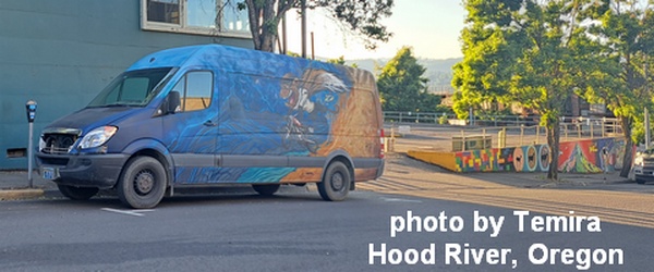
Sprinter Van of the Week!
 Click here for the Sprinter Van map of the world!!!
Have an awesome day!
