

GORGE WIND FORECAST
If you’re still seeing yesterday’s and it’s after 9am, try opening this in an incognito window
today’s gorge wind forecast
Hi friends! Another decent day on the river is on tap today – it’s Saturday. That’s followed by somewhat lesser wind for a few days as temps start to climb again. We have lots of uncertainty in the middle part of next week as thunderstorms enter the picture, but we should be back to moderately strong westerlies for the latter part of next week. Uncertainty is high, so I’ll broad brush it. In the meantime…
Today starts with the PSAs: Doug’s Beach has reopened per WA State Parks. However, if you are there (or anywhere else) and see aircraft scooping water nearby, get off the water and go elsewhere. I know you don’t want to interfere with fire ops! Next up: I found ANOTHER Ion wetsuit on the freeway (Frogger seems to be my new game). This one was out by Rufus, and it’s a women’s suit. If you think it’s yours, reach out to me with a description.
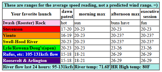
Today’s pressures at 8am were 29.99/29.88/29.87 for gradients of 0.11 (PDX-DLS) and 0.01 (DLS-PSC). Marine clouds surged past Hood River while I was writing this forecast. We’ll see westerlies at gusty 20-23mph early from Swell to Doug’s with 14-17mph from Stevenson to Viento and also east of The Dalles to Arlington. Mid-morning wind holds at 20-23mph near Swell (btw, it’ll start gusty with these clouds and should steady out as they burn back) and fills in from Stevenson to Mosier. Afternoon: a slow build to 23-26mph from Mosier to Doug’s with 26-29mph from Avery to Arlington (remembering that those eastern Gorge sensors read high compared to Swell and other western Gorge sensors). Given the persistence of low clouds on the west side, we might get lucky with 20-23mph between Stevenson and Hood River this afternoon. If the metro area clears off faster than expected, that zone will drop to 17-20mph. River flow over the last 24 hours was 95-131kcfs (105-131kcfs at Rufus). River temp is 71.6F (poor salmon), and high temp forecast is 80F for Hood River and 88F for Rufus.
RIVER FLOW FOR SITES BETWEEN AVERY (EAST OF THE DALLES) AND RUFUS: CLICK HERE FOR JOHN DAY DAM FLOW.
RIVER FLOW FOR SITES BETWEEN STEVENSON AND DOUG’S BEACH (WEST OF THE DALLES): CLICK HERE FOR THE DALLES DAM FLOW

tomorrow’s gorge wind forecast
Sunday sees a low pressure system building in the NE Pacific, and it also sees heat building on the west side. These combine to knock the wind down from Saturday’s strength. The day stars with 19-22mph from Viento to Mosier with 11-14mph east of Mosier to Arlington. Midday wind fills in at 19-22mph from Stevenson to Mosier with 14-17mph from Lyle to Avery. Afternoon: 17-20mph from Stevenson to Arlington. High temps range from 84F in Hood river to 89F at Arlington.
extended Gorge wind forecast
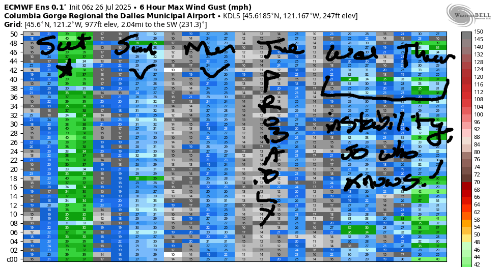
Ensembles suggest lesser wind on Monday, although the GFS deterministic has the wind stronger than on Sunday. For now, let’s call it 17-20mph from Stevenson to Mosier in the morning and 17-20mph from Stevenson to Doug’s or Rufus in the afternoon. Lesser wind is forecast on Tuesday. Models are all over the place for Wednesday in part because of the possibility of thunderstorms. Thunderstorms make clouds in random places. If we can’t predict the cloud cover, we can’t predict high temps, and if we can’t accurately predict high temps, we can’t predict the wind.
Ditto on Thursday, although models have a big drop in temps and potential for accompanying big wind… unless the thunderstorms dominate the weather. Beyond that… models hint at decent wind next Friday, Saturday, and Sunday. That’s all for now. Have a great day on the river!
Was that helpful? I knew it was! Guess what? All of this crucial work – from your personal wind and snow reports to the invaluable TATAS updates – is made possible by my relentless efforts. Maintaining this labor of love isn’t easy. Each daily forecast takes hours. Website hosting, weather model access, and back-end admin work takes time and money. That’s where you come in.
YOUR CONTRIBUTION MAKES A DIFFERENCE
- SUPPORT ACCURATE, HYPER-LOCAL WEATHER FORECASTING
- ENABLE ACCESS FOR ALL, EVEN THOSE WITH LESS MEANS
- SUPPORT A COOL HUMAN WHO WORKS HARD SO YOU CAN PLAY
Take a moment to click one of the buttons below. Donate $19.99 or more (how much does this forecast enhance your life?) and get the email in your inbox. Whether it’s a renewing subscription (auto-renew) or a one-time donation, every contribution makes a real difference. Help me keep this labor of love alive, so we can all continue playing, commuting, and living in the Gorge with peace of mind and the best weather forecasts possible. Thank you!


Hood River, Oregon 97031


JONES BEACH, SAUVIE ISLAND, & COAST FORECAST
Wind northerly unless otherwise indicated. For coast, it’s North/Central/South with the “central” at approximately Florence. Swell forecast from NWS for central coast. Jones: westerly unless otherwise stated. Sauvie Island: northerly unless otherwise stated. Coast Saturday: LTNW/NW5-10/NNW15-20, NW swell 3′ at 8 seconds. Sunday: LTW/LTNW/N15, NW 2′ @ 8. Monday: NW10-15/NNW10-15/NNW20, NW 3′ @ 8. Jones Saturday: 14-17. Sunday: 12-15. Monday: 19-22. Sauvie Island Saturday-Monday: 9-12.
BARE BONES HOOD RIVER WEATHER FORECAST
Clear sky today after a few morning clouds. Temps start in the low 60s and rise to 80. Moderately strong westerlies. No rainbows. Sunday will be sunny. Temps star tin the upper 50s and rise to the mid 809s. Moderate westerlies. No rainbows. Monday will be mostly clear. Temps start in the low 60s and rise to the upper 80s. Moderate westerlies. No rainbows.
TEMIRA’S AWESOME TRAVEL ADVISORY SERVICE – SATURDAY 7/26
HYPERLOCAL WEATHER FORECAST FOR THE COLUMBIA GORGE
THE DALLES, HOOD RIVER, WHITE SALMON, TROUT LAKE, STEVENSON, CASCADE LOCKS, PARKDALE, ODELL, HUSUM, BZ, MILL A, WILLARD, GOLDENDALE, RUFUS, ARLINGTON, boardman
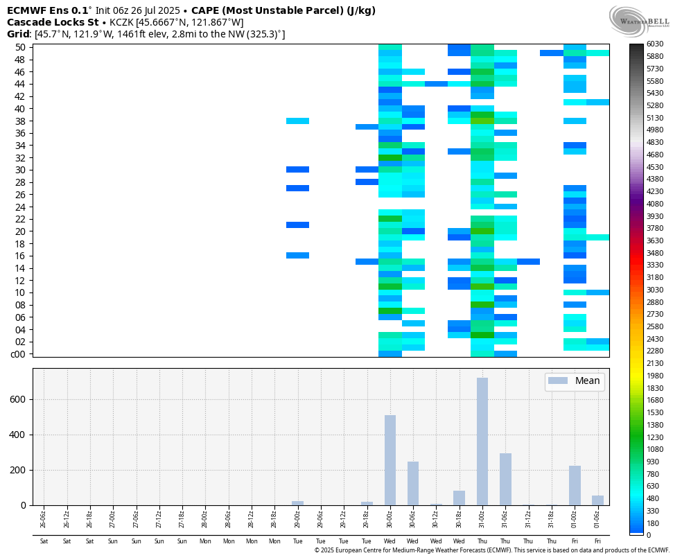
Good morning, neighbors! Despite all the wind yesterday, our fires remained contained in their footprints. No new fires started. THANK YOU FIRE CREWS! Today, Saturday, looks like a nice cool summer day. Starting tomorrow, temps warm. Starting Tuesday, moisture streams in from the south and thunderstorms become a possibility. See image for Convective Available Potential Energy, which is similar to Fart Available Resting Threat, which is what happens when you eat lots and lots and lots of ripe cherries. Let’s all vote for tons of rain and zero lightning! Okay, that’s not based in reality. Instead, let’s just vote for tons of rain along with any storms that do materialize.
GLENWOOD THIS MORNING
Before we do anything else, before we drink coffee, before we poop, let’s check in with Glenwood: it was 47 degrees there this morning, and everyone was walking their dogs and cats and smiling and saying “good morning” to the neighbors. We’re social creatures, us humans. Ignoring each other as we walk by only contributes to our own sense of loneliness and separation. Do you feel lonely and separate sometimes? If you do, try being like the friendly folks in Glenwood today and smiling, acknowledging, and saying hi to others.
TODAY’S GORGE WEATHER FORECAST
In other Gorge locations this morning… clouds to the west and sun to the east with just a few little fluffy clouds in Hood River above the big, rolling whitecaps. Temps rise to 80 (west), 86 (The Dalles) and 92 (watermelon zone) today. West wind rises to 20mph west of Mosier and 25-30mph east of Mosier to the Arlington Triangle. The sky eventually turns clear all across the land.
SUNDAY’S GORGE WEATHER FORECAST
Overnight temps drop into the 50s, but Sunday will be a few degrees warmer than Saturday thanks to a clear sky start. Open up your windows and doors in the morning to trap Ma Nature’s air conditioning in your home. We max out at 84 (west), 89 (central), and 94 (way out east. West wind will be 15-20mph from Viento to Mosier to start with 15-20mph from Stevenson to Arlington in the afternoon. Monday looks a few degrees warmer yet with about the same amount of wind.
EXTENDED GORGE WEATHER FORECAST
Things get more interesting Tuesday through Thursday as moisture streams into the area from the south. MUGGY! Add in a little weather disturbance on Wednesday or Thursday for a decent chance of thunderstorms. Given the copious available moisture (about 2 sigmas above normal), any storms that do form could drop lots of water. With temps forecast to be hot, 95-100 degrees on Tuesday and Wednesday, this could be an interesting time. Still have cherries to harvest during the middle of next week? Feel free to check in with me about the upcoming weather.
Uncertainty increases starting Wednesday and continues for the extended period; that said, high temps Thursday will be down 10-15 degrees from Wednesday. That sets us up for strong west wind for a day or two. That is all for now. I’m running late because I led a meditation group at 7am today, so I’ll finish up. Meditatoin stuff is one of my favorite things in the world. And you thought I was just a crass-mouthed forecaster. Ha. Fuckin’ fooled ya! Safe travels. -TATAS
HEY! DON’T STOP READING! Is this community-focused forecast helpful to you? It sure is! It takes me a couple hours a day to write. Please join your friends and neighbors in contributing to keep it going. Venmo: @thegorgeismygym PayPal: twomirrors@gmail.com USPS: Temira / PO Box 841 / Hood River, Oregon 97031 You can test out the forecast subscription for a few days for free by signing up below. Easy! Do it!
