

GORGE WIND FORECAST
If you’re still seeing yesterday’s and it’s after 9am, try opening this in an incognito window
today’s gorge wind forecast
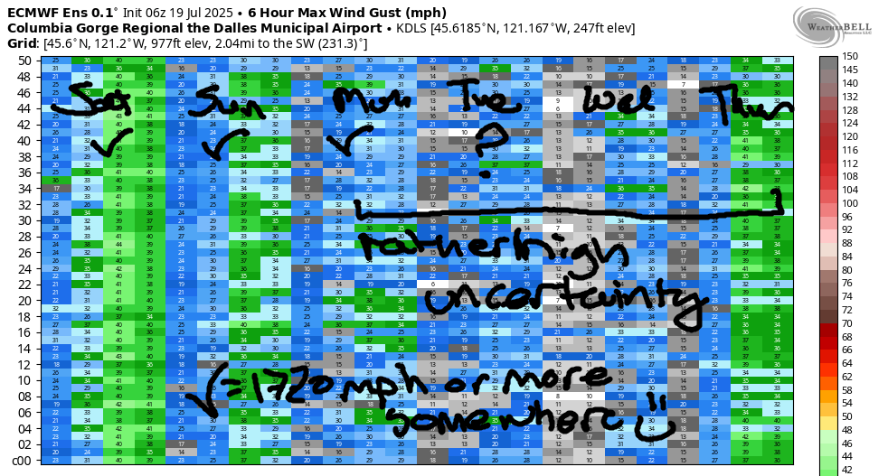
Hi friends! It’s another windy day in the Gorge, and unfortunately we have another large wildfire burning here. If you see planes and helicopters scooping water near where you’re recreating, get off the water and go somewhere else. Let’s do everything we can to support the folks affected by the Burdoin fire and also the folks working to protect homes and contain the fire. FYI, SR-14 is closed between Bingen and MP 76 due to the Burdoin Fire. On to the forecast: we’ll have wind for at least the next three days – today looks like the strongest. Beyond that, there’s quite a bit of uncertainty in the Gorge wind forecast and the general weather forecast, so I’ll be broad-brushing things a few paragraphs from now.
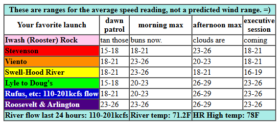
Let’s take a look at Saturday morning: early pressures were 30.09/29.97/29.89 for gradients of 0.12 (PDX-DLS) and 0.08 (DLS-PSC). Gradients like that suggest you’ll be happy anywhere between Stevenson and Rufus today. It’s worth noting that a weak system approaching northern WA is likely to make the wind gusty today, especially this afternoon, and it could also cause wind speeds to under-perform. Early wind was within a few mph of 20mph everywhere but Arlington this morning – that launch started with 28mph (which is equivalent to about 21mph on the Swell sensor). Morning westerlies rise to 21-24mph from Viento to Doug’s with 24-27mph from Rufus to Arlington. By late morning or early afternoon, we’ll have 23-26mph from Stevenson to Mosier with 25-29mph from Lyle to Arlington. Swell is likely to drop to 16-19mph early afternoon as the stabilizing cap breaks on the west side. River flow over the last 24 hours was 110-201kcfs, river temp is 71.2F (poor salmon), and high temp forecast is 78F for Hood River and mid 80s for Rufus.
RIVER FLOW FOR SITES BETWEEN AVERY (EAST OF THE DALLES) AND RUFUS: CLICK HERE FOR JOHN DAY DAM FLOW.
RIVER FLOW FOR SITES BETWEEN STEVENSON AND DOUG’S BEACH (WEST OF THE DALLES): CLICK HERE FOR THE DALLES DAM FLOW

tomorrow’s gorge wind forecast
A system off the coast Sunday sends all sorts of clouds into the Gorge. Expect inconsistent and gusty wind with this setup. Early wind looks like 18-21mph from Stevenson to Arlington. Westerlies west of Mosier slowly fade to 14-17mph by the afternoon. From Mosier to Rufus, the wind holds at gusty 18-21mph or a bit more. Arlington also fades to 14-17mph by afternoon. High temp: 78F for Hood River and 86F out in the desert with quite a few clouds in the sky.
extended Gorge wind forecast
That same system causes atmospheric instability on Monday, which will definitely affect wind quality and speed. That said… it still looks windy. The day starts with 13-16mph from Viento to Mosier with 8-11mph at Stevenson and also east of Mosier to Arlington. Afternoon wind rises to gusty 18-21mph from Stevenson to The Dalles with 14-17mph at Avery and less to the east. High temp: 80F in Hood River with partly cloudy sky and a slight chance of instability-driven sprinkles.
Temps rise Tuesday and Wednesday, and wind speeds drop. Uncertainty is high for this time period; some ensemble members give us 17-20mph or more, and some do not. There are hints of some sort of cooldown for the Thursday-Saturday period. That would result in stronger westerlies. Models are pretty sure we’ll have wind for that time period, but they’re not clear on how much. That’s all for today. Keep our fire-affected neighbors in your minds. Have a great day on the river. I’ll see you out there!
JONES BEACH, SAUVIE ISLAND, & COAST FORECAST
Wind northerly unless otherwise indicated. For coast, it’s North/Central/South with the “central” at approximately Florence. Swell forecast from NWS for central coast. Jones: westerly unless otherwise stated. Sauvie Island: northerly unless otherwise stated. Coast Saturday: LTNW/NNW10-15/N25-30, NW swell 4′ at 8 seconds. Sunday: NW10/NNW10-15/N20-25, NW 3′ @ 7. Monday: NNW10-15/N15/N20-25, NW swell 3′ @ 8 seconds. Jones Saturday: 16-19. Sunday: 10-13. Monday: 15-18. Sauvie Island Saturday: 10-13. Sunday: 7-10. Monday: 10-13.
BARE BONES HOOD RIVER WEATHER FORECAST
Sunny in the morning with some high clouds later. Temps start in the low 60s and rise to the upper 70s. Moderately strong westerlies. No rainbows. Sunday will be mostly cloudy. Temps start in the upper 50s and rise to the upper 70s. Moderate westerlies. No rainbows. Monday will be partly cloudy with instability and a chance of sprinkles. Temps start in the upper 50s and rise to 80. Moderate westerlies. No rainbows.
TEMIRA’S AWESOME TRAVEL ADVISORY SERVICE
HYPERLOCAL WEATHER FORECAST FOR THE COLUMBIA GORGE
THE DALLES, HOOD RIVER, WHITE SALMON, TROUT LAKE, STEVENSON, CASCADE LOCKS, PARKDALE, ODELL, HUSUM, BZ, MILL A, WILLARD, GOLDENDALE, RUFUS, ARLINGTON, boardman
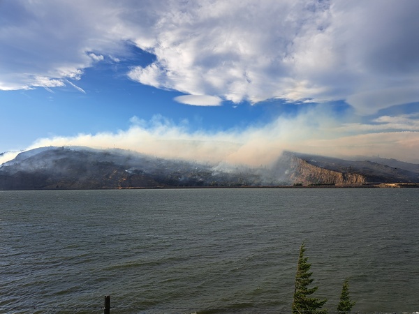
Good morning, neighbors! Actually, it’s kind of a shitty morning here in the Gorge as another massive fire is underway. So far 3 homes have been destroyed and 5 damaged (per NWCC) and 1900 acres burned. My heart goes out to all affected, and my thanks go to all involved with the fire fighting efforts. SR-14 remains closed east of Bingen to MP 68. With plenty of wind in the forecast and no rain in sight, the fire is likely to grow today. Be safe out there, folks.
glenwood this morning and today’s gorge weather forecast
Before we dive into the forecast like a super-scooper diving into the Columbia (stay far away from those planes and choppers – no windsports in dipping areas, okay?), let’s check in with Glenwood. 43 degrees there this morning, enough to allow folks to bundle up while watching the sunrise. Gorge temps today rise to 78 (west), 85 (The The The Dalles), and 90 (out in the watermelon-growing zones near Hermiston). West wind will be 15-20mph this morning from Stevenson to Arlington. Afternoon wind will be 20-25mph from Stevenson to Mosier with 25-30mph from Lyle to Rufus with 20mph out near Arlington.
sunday’s gorge weather forecast
Sunday looks like a good day to get a handle on a fire: a mix of mid and high-level clouds keep the fire fighting crews a bit cooler. Temps will be in the upper 50s in the morning. Afternoon sees 78 (west), 85 (The The Dalles), and 86 (way out east). West wind will be 20mph in the morning between Viento and Mosier with 15-20mph from Lyle to Arlington. Afternoon wind will be 15-20mph between Stevenson and Hood River with 20-25mph between Mosier and Rufus. To the east: less wind.
extended gorge weather forecast
Instability and a wee chance of a few sprinkles enter the picture on Monday as a low or trough dances around the PNW. This gives us at least some clouds, probably of the little fluffy cloud variety (What were the skies like when you were young?). Wind will be 10-15mph in the morning and 15-20mph in the afternoon west of Avery with lighter wind to the east. Somewhat warmer weather with somewhat lighter wind is likely Tuesday and Wednesday and potentially Thursday, although temps could start to cool on Thursday which would make it windier. That’s all I’ve got for now. Check in with your friends on the WA side and see how they’re doing. Wildfire isn’t just terrifying for folks directly affected – it can put anyone on edge. Take care of yourself too as you take in the news about the fire, okay? Sending all of you lots of care. Safe travels. -TATAS
HEY! DON’T STOP READING! Is this community-focused forecast helpful to you? It sure is! It takes me a couple hours a day to write. Please join your friends and neighbors in contributing to keep it going. Venmo: @thegorgeismygym PayPal: twomirrors@gmail.com USPS: Temira / PO Box 841 / Hood River, Oregon 97031 You can test out the forecast subscription for a few days for free by signing up below. Easy! Do it!
