

GORGE WIND FORECAST
If you’re still seeing yesterday’s and it’s after 9am, try opening this in an incognito window
today’s gorge wind forecast
Hi friends! Yesterday morning was a monster at the Hatch. If you missed it, don’t worry. The Gorge wind forecast for the next three days is “big”. As of right now, it looks like the Corridor (Swell to Hood River) and the Near East (Mosier to Doug’s) will fire off at some point each day. We’ll add strong wind at Rufus Sunday and Monday as well with Arlington likely for Monday.
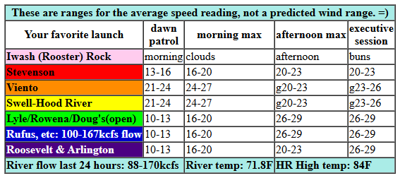
Saturday kicked off with a very sleepy Temira trying to write a forecast… we’ll see how this goes! Pressures at 7am were 30.26/30.14/30.12 for gradients of 0.12/0.02. Metro area: cloud-covered. Thanks to 95 degrees in the desert this afternoon, we’ll have an increasingly windy day. Early wind was 21-24 from Viento to Hood River with 13-16mph at Stevenson and 10-13mph out east. For the morning, 24-27mph from Viento to Mosier seems reasonable with 20-23mph at Stevenson and 17-20mph from Lyle to Doug’s.
Afternoon westerlies hold at 20-23mph (or more if the metro area cloud can hold) from Stevenson to Hood River and rise to 24-27mph between Mosier and Rufus with 14-17mph at Arlington. Evening: 23-26mph from Stevenson to Mosier with 26-29mph from Lyle to Arlington. Will we see a midday lull at the Hatch like we did yesterday? Depends on how early the metro area clouds burn off! Also, remember that those eastern Gorge sensors read high compared to Swell: 30mph at The Wall and Arlington is approximately equivalent to 20-23mph at Swell. River flow over the last 24 hours was 88-170kcfs, river temp is 71.8F, and high temp forecast is 84F for Hood River and 91F at Rufus.
RIVER FLOW FOR SITES BETWEEN AVERY (EAST OF THE DALLES) AND RUFUS: CLICK HERE FOR JOHN DAY DAM FLOW.
RIVER FLOW FOR SITES BETWEEN STEVENSON AND DOUG’S BEACH (WEST OF THE DALLES): CLICK HERE FOR THE DALLES DAM FLOW

tomorrow’s gorge wind forecast
On Sunday, a trough (cool air) approaches the PNW and moves inland. This reinforces cool air on the west side and maintains a solid cross-Cascade temp gradient. Metro area: cloudy for the morning for sure and eventually clearing. Dawn Patrol looks solid: 25-28mph from Viento to Mosier. I can’t rule out 28-31mph mid-morning from Viento to Mosier, but I’m not quite ready to jump on board with that… yet… Lyle to Doug’s quickly joins at 24-27mph.
Afternoon wind rises to 28-32mph from Mosier to Rufus with the Hatch dependent on the west side clouds. I would not be surprised if this is one of those rare days when the Corridor (Swell to Hood River) stays strong all day. Evening: 28-32mph all the way out to Arlington with the Hatch likely gusty but still strong. One thing to note: as this trough approaches, it’s likely to briefly destabilize the wind field. Do not be surprised if the direction shifts and the wind turns lighter, gusty, and less reliable for an hour or three midday. High temps;: 78F for Hood River and 87F at Rufus.
extended Gorge wind forecast
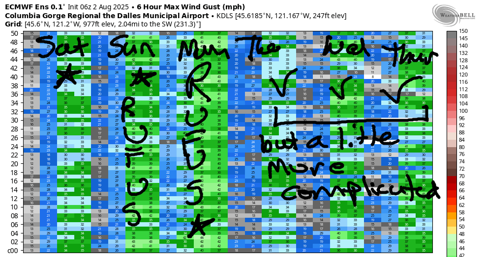
Solid marine clouds stick around in the metro area all day Monday. Lots of moving pieces are involved, but the wind will be strong right off the bat. Models have dawn patrol at 26-29mph from Viento to Threemile with Stevenson cloudy and lighter. Afternoon: 28-32mph from Viento to Rufus with a little less at Arlington. Models suggest a low approaching the coast will take the speeds down 5mph or so late afternoon into the evening, so keep that in mind. Still… it should be nuking until 4-5pm and plenty wind, 24-27mph, into the evening. High temp: 74F for Hood River and 82F for Rufus. Slightly lesser wind, but still almost certainly 20mph or more, continues Tuesday and Wednesday. Thursday looks a bit lighter. That’s all for now. See you on the Nch’i Wana!
Was that helpful? I knew it was! Guess what? All of this crucial work – from your personal wind and snow reports to the invaluable TATAS updates – is made possible by my relentless efforts. Maintaining this labor of love isn’t easy. Each daily forecast takes hours. Website hosting, weather model access, and back-end admin work takes time and money. That’s where you come in.
YOUR CONTRIBUTION MAKES A DIFFERENCE
- SUPPORT ACCURATE, HYPER-LOCAL WEATHER FORECASTING
- ENABLE ACCESS FOR ALL, EVEN THOSE WITH LESS MEANS
- SUPPORT A COOL HUMAN WHO WORKS HARD SO YOU CAN PLAY
Take a moment to click one of the buttons below. Donate $19.99 or more (how much does this forecast enhance your life?) and get the email in your inbox. Whether it’s a renewing subscription (auto-renew) or a one-time donation, every contribution makes a real difference. Help me keep this labor of love alive, so we can all continue playing, commuting, and living in the Gorge with peace of mind and the best weather forecasts possible. Thank you!


Hood River, Oregon 97031


JONES BEACH, SAUVIE ISLAND, & COAST FORECAST
Wind northerly unless otherwise indicated. For coast, it’s North/Central/South with the “central” at approximately Florence. Swell forecast from NWS for central coast. Jones: westerly unless otherwise stated. Sauvie Island: northerly unless otherwise stated. Coast Saturday: 15/20/25-30, NW swell 3′ at 7 seconds. Sunday: NNW10/NNW10/N25, NW 3′ @ 7. Monday: LTNW/NNW10/N20-25, NW 3′ @ 5. Jones Saturday: 21-24. Sunday: 18-21. Monday: LTW. Sauvie Island Saturday: 11-14. Sunday: 13-16. Monday: 8-11.
BARE BONES HOOD RIVER WEATHER FORECAST
Clear sky this morning and all day long. Temps start in the mid 60s and rise to the mid 80s. Strong westerlies. No rainbows. Sunday will be partly cloudy then clear. Temps start in the upper 50s and rise to the upper 80s. Strong westerlies. No rainbows. Monday will be partly to mostly cloudy then mostly clear. Temps start in the mid 50s and rise to the mid 70s. Strong westerlies. No rainbows.
TEMIRA’S AWESOME TRAVEL ADVISORY SERVICE
HYPERLOCAL WEATHER FORECAST FOR THE COLUMBIA GORGE
THE DALLES, HOOD RIVER, WHITE SALMON, TROUT LAKE, STEVENSON, CASCADE LOCKS, PARKDALE, ODELL, HUSUM, BZ, MILL A, WILLARD, GOLDENDALE, RUFUS, ARLINGTON, boardman

Good morning, neighbors! A (relatively) cool and (not relatively) windy weekend is on tap. How cool? Temps should be at or below 90 degrees for The Dalles through next Thursday, which I guess is much longer than “the weekend”, but I”m still really sleepy so you’ll have to forgive me. There’s a wee chance of rain with a weather system on Wednesday, and hot weather is likely next weekend.
glenwood this morning
Let’s check in with Glenwood, shall we? Those folks started today at 46 degrees, nearly 20 degrees cooler than at my house. But still, it’s cool enough for all of us to open our windows, and it’s warm enough to drink coffee outside. Enjoy it!
today’s gorge weather forecast
Today turns warm and windy. Actually, it was quite windy already as I was writing this. Temps max out in the mid 80s (west), 90 (Dallesport, you thought I was gonna say “The Dalles”), and 95 (out where the cantaloupe roam). West wind picks up to 25-30mph from Viento to Mosier this morning and from Stevenson to Rufus this afternoon with 20-25mph near the Arlington Triangle.
sunday’s gorge weather forecast
Sunday start off cool – probably under 60 degrees for many. Rest of the day: windy and cooler. Temps max out in the upper 70s (west) mid 80s (The Dalles) and low 90s (out where the melons roam, unhindered by bras or societal expectations). Westerlies will be 25-35mph all day from Viento to Mosier and 25-35mph in the afternoon from Stevenson to Rufus. Monday looks very much like Sunday but a little cooler and much cloudier west of Hood River. Tuesday, Wednesday, and Thursday also look to remain under 90 degrees for The Dalles and under 80 degrees for Hood River. There’s even a chance of a little rain on Wednesday. PLEASE LET IT RAIN! Looking beyond that… Cool on Thursday and slowly warming into the weekend. I’d say more, but it’s very windy out there, and I gotta finish this up and get on the river! Safe travels. -TATAS
HEY! DON’T STOP READING! Is this community-focused forecast helpful to you? It sure is! It takes me a couple hours a day to write. Please join your friends and neighbors in contributing to keep it going. Venmo: @thegorgeismygym PayPal: twomirrors@gmail.com USPS: Temira / PO Box 841 / Hood River, Oregon 97031 You can test out the forecast subscription for a few days for free by signing up below. Easy! Do it!
