

GORGE WIND FORECAST
today’s gorge wind forecast
Hi friends! We’re still on tap for a strong wind day here in the Gorge, and it’s kindly starting out light so coffee can be consumed casually. If you can’t make it today for whatever reason, don’t worry – ensembles give us 20+ mph every single day between now and next Friday. There are strong signs of hot weather and east wind potential for next weekend. If you’re one of the lucky folks who can play during the week, you’ll be begging for a rest day by next weekend!
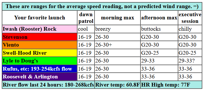
Saturday started off with pressures of 30.03/29.96/29.94 for gradients of 0.07 (pdx-dls) and 0.02 (dls-psc). Offshore: moderately strong high pressure of 1028mb. A cold front approaches the coast today while heat lingers in the desert and offshore high pressure builds to 1032mb. Combine the three for strong west wind. Those of you seeking the strongest of wind should consider the Avery-Arlington zone from noon on. Elsewhere: we’ll see westerlies build to 29-33 from Stevenson to Arlington by early afternoon. 33-38 is possible from Avery to Threemile this afternoon with 30-33 from Threemile to Boardman.
Models bring low clouds to Stevenson and potentially as far east as The Dalles early afternoon. Any location that ends up under the cloud cover will see wind speeds drop and turn very gusty. Today’s big question mark is Swell-Hood River. We should see a period of strong westerlies in that zone prior to the clouds arriving late morning or early afternoon – call it 26-30 on the sensors. Once the clouds arrive, assuming they do, there will be a dramatic drop-off. Viento is likely to stay strong despite the clouds. It has a habit of doing that during frontal passages. So, to recap: strongest, steadiest, longest-lasting wind will be east of The Dalles today. River flow over the last 24 hours was 180-268kcfs (193-254kcfs at Rufus with 253kcfs this morning), river temp is 60.8F, and high temp forecast is 77F for Hood River and 82F at Arlington. Stay hydrated!

tomorrow’s gorge wind forecast
Sunday starts off with low clouds on the west side and sun out east. This gives the desert a jump on heating. With the NE Pacific high forecast to strengthen to 1036mb, reality is likely to outperform the models. The day starts with 17-20 from Viento to Mosier with 10-13 at Stevenson and less than 10mph out east. Afternoon westerlies build to 23-26 from Stevenson to Doug’s; there is a weak system forecast to move through, and that’s likely to impact wind strength and quality near the Hatch in the afternoon. Eastern Gorge: not much wind on Sunday. High temp: 77F.
extended Gorge wind forecast

Offshore high pressure combines with a WA desert heat low on Monday for another round of westerlies. Call it 20-23 to start from Viento to Mosier with 25-28 (Stevenson to Avery) to finish. Rufus looks like 20-23 on Monday. Generally speaking, the forecast for next week has similar wind – mid 20s – every day through Friday with the potential for somewhat stronger wind Thursday and Friday. Beyond that, the ECMWF ensembles are insisting on a few days of hotter weather and a probable break for the wind next weekend. So, you’d better make the most of this weekend! See you on the Nch’i Wana!
Was that helpful? I knew it was! Guess what? All of this crucial work – from your personal wind and snow reports to the invaluable TATAS updates – is made possible by my relentless efforts. Maintaining this labor of love isn’t easy. Each daily forecast takes hours. Website hosting, weather model access, and back-end admin work takes time and money. That’s where you come in.
YOUR CONTRIBUTION MAKES A DIFFERENCE
- SUPPORT ACCURATE, HYPER-LOCAL WEATHER FORECASTING
- ENABLE ACCESS FOR ALL, EVEN THOSE WITH LESS MEANS
- SUPPORT A COOL HUMAN WHO WORKS HARD SO YOU CAN PLAY
Take a moment to click one of the buttons below. Donate $19.99 or more (how much does this forecast enhance your life?) and get the email in your inbox. Whether it’s a renewing subscription (auto-renew) or a one-time donation, every contribution makes a real difference. Help me keep this labor of love alive, so we can all continue playing, commuting, and living in the Gorge with peace of mind and the best weather forecasts possible. Thank you!


Hood River, Oregon 97031


JONES BEACH, SAUVIE ISLAND, & COAST FORECAST
Wind northerly unless otherwise indicated. For coast, it’s North/Central/South with the “central” at approximately Florence. Swell forecast from NWS for central coast. Jones: westerly unless otherwise stated. Sauvie Island: northerly unless otherwise stated. Saturday: 20-25/25/30-35, W swell 4′ at 11 seconds. Sunday: 25/30-35/nuking, W 4′ @ 16. Monday: 20/25/nuking, NW 5′ @ 12. Jones Saturday: 21-24. Sunday: 21-24. Monday: 23-26. Sauvie Island Saturday: 16-19. Sunday: 20-23. Monday: 16-19.
BARE BONES HOOD RIVER WEATHER FORECAST
Mostly clear this morning, mostly cloudy midday, partly cloudy this afternoon. Temps start in the upper 50s and rise to the upper 70s. Light westerlies early. Very strong westerlies midday. NO rainbows. Sunday will be partly to mostly cloudy then sunny. Temps start in the upper 40s and rise to the upper 70s. Moderate westerlies early. Moderately strong westerlies later. No rainbows. Monday will be partly cloudy then clear. Temps start in the upper 40s and rise to the upper 70s. Moderate westerlies early. Strong westerlies later. No rainbows.
TEMIRA’S AWESOME TRAVEL ADVISORY SERVICE – SATURDAY 5/31
HYPERLOCAL WEATHER FORECAST FOR THE COLUMBIA GORGE
THE DALLES, HOOD RIVER, WHITE SALMON, TROUT LAKE, STEVENSON, CASCADE LOCKS, PARKDALE, ODELL, HUSUM, BZ, MILL A, WILLARD, GOLDENDALE, RUFUS, ARLINGTON, boardman
Good morning, neighbors! Are you ready for a challenge today? Today’s challenge is to not start any wildfires. I believe we’re at three for the season so far. With very strong wind forecast today, any fire that starts will have the potential to spread far and fast. Dry, breezy, slightly-warmer-than-normal weather is forecast all the way through next week. That’s followed by (most likely scenario) hotter weather next weekend.
Glenwood this morning
This morning in Glenwood we have folks in their porch-based rocking chairs sipping coffee. On the lap of each person in Glenwood: a wool blanket topped with a purring cat. It’s 43 degrees there as I write this, just warm enough for steam to rise from those coffee cups. Yup, it’s a peaceful morning in Glenwood ahead of a very windy afternoon.
today’s gorge weather forecast
A cold front (it’s not really all that cold, but it’s cooler than yesterday’s air) arrives today. Associated clouds (from the Associated Press) arrive midday and push as far east as Hood River or maybe even The Dalles. Out in the desert, clear sky persists. In response to all this, westerlies pick up to 30-40mph everywhere between Stevenson and Boardman. Up in the hills, you will have strong and gusty NW wind. Know what this cold front is lacking? Moisture, sadly. No rain is forecast. Given the dry conditions and the super-strong wind, you’ll want to be very careful with fire and spark-causing implements such as a lawn mower, a weed wacker, or a Hitachi Magic Wand. Max temps today will be mid 70s to the west and low 80s to the east.
sunday’s gorge weather forecast
We’ll cool off into the upper 40s tonight. West side locations start cloudy on Sunday while areas to the east start mostly clear. Morning wind will be 15-20mph between Viento and Mosier with light wind to the east. Afternoon wind rises to 25mph between Stevenson and The Dalles with less than 15mph to the east. High temps climb to the mid-upper 70s under sky that clears all across the land.
extended gorge weather forecast
We can pretty much copy/paste that Sunday forecast for every day next week. Temps hold in the mid 70s early in the week and climb towards 80 for the second half of the week. It’ll be breezy every single day with westerlies in the 20-30mph range. Models have a consensus (for now, anyway) on ridging and heat and calm conditions for next weekend with temps climbing into the low 90s. That sounds really hot right now, but maybe it won’t feel that way when it arrives. This week I am practicing eliminating all self-caused suffering around weather. As a Wind Johnnie, that’s hard, but I’m dedicated to this. Join me if you like. Just welcome the weather as it comes rather than worrying about it. Safe travels. -TATAS
HEY! DON’T STOP READING! Is this community-focused forecast helpful to you? It sure is! It takes me a couple hours a day to write. Please join your friends and neighbors in contributing to keep it going. Venmo: @thegorgeismygym PayPal: twomirrors@gmail.com USPS: Temira / PO Box 841 / Hood River, Oregon 97031 You can test out the forecast subscription for a few days for free by signing up below. Easy! Do it!
