

GORGE WIND FORECAST
If you’re still seeing yesterday’s and it’s after 9am, try opening this in an incognito window
today’s gorge wind forecast
Hi friends! Yesterday did some over-performing to the delight of many of us – I was able to sneak in a lap before heading to Portland, and that made me a very happy camper! We’ll see an east/west day today. After this, the weather turns much more active, which means the wind will turn much less reliable for that period of active weather. While we can’t rule out periods of strong-enough westerlies with the frontal passages this week, what wind we see will be short-lived, gusty, and hard to predict.
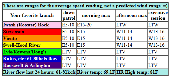
First, let’s take a look at today. East gradients started the day: 29.89/29.94 for 0.05 offshore. That’ll give rise to 15mph at Stevenson/Home Valley/Viento and 15-20mph at Iwash (Rooster) Rock this morning. The wind drops quickly. In the afternoon, we’ll see a switch to west wind. Models are all over the place with predictions of 5-10mph to 13-16mph between Stevenson and Hood River. If we get those stronger westerlies, it won’t be until the evening. To the east of Hood River, expect light wind all day. River flow over the last 24 hours was 61-81kcfs, river temp is 69.1F, and high temp forecast is 81F.
RIVER FLOW FOR SITES BETWEEN AVERY (EAST OF THE DALLES) AND RUFUS: CLICK HERE FOR JOHN DAY DAM FLOW.
RIVER FLOW FOR SITES BETWEEN STEVENSON AND DOUG’S BEACH (WEST OF THE DALLES): CLICK HERE FOR THE DALLES DAM FLOW

tomorrow’s gorge wind forecast
Sunday starts off light; max early speeds will be found from Viento to Hood River where we may see westerlies at 10-13mph. As a system approaches in the afternoon, westerlies rise to gusty 14-17mph from Stevenson to Swell with gusty 17-20mph from Mosier to Rufus. A period of 17-20mph near Swell is possible too – jump on it, because it’s unlikely to last long. High temp: 80F with increasing high clouds.
extended Gorge wind forecast
That weather system moves through on Monday and drags some light drizzle in to the western Gorge. Early wind will be calm. Afternoon: 7-10mph from Stevenson to Doug’s with gusty 20-23mph from Avery to Rufus. High temp: 68F and clouds. A series of weather systems moves through next week. While there may be a bit of west wind with each frontal passage, models are not optimistic about any sustained periods of wind either easterly or westerly. Models are somewhat optimistic about rain, meaning you may have a chance to take a break from the river and find yourself some excellent mountain biking dirt. Fingers crossed. See you on the Nch’i Wana or out on the trails!
Was that helpful? I knew it was! Guess what? All of this crucial work – from your personal wind and snow reports to the invaluable TATAS updates – is made possible by my relentless efforts. Maintaining this labor of love isn’t easy. Each daily forecast takes hours. Website hosting, weather model access, and back-end admin work takes time and money. That’s where you come in.
YOUR CONTRIBUTION MAKES A DIFFERENCE
- SUPPORT ACCURATE, HYPER-LOCAL WEATHER FORECASTING
- ENABLE ACCESS FOR ALL, EVEN THOSE WITH LESS MEANS
- SUPPORT A COOL HUMAN WHO WORKS HARD SO YOU CAN PLAY
Take a moment to click one of the buttons below. Donate $19.99 or more (how much does this forecast enhance your life?) and get the email in your inbox. Whether it’s a renewing subscription (auto-renew) or a one-time donation, every contribution makes a real difference. Help me keep this labor of love alive, so we can all continue playing, commuting, and living in the Gorge with peace of mind and the best weather forecasts possible. Thank you!


Hood River, Oregon 97031


JONES BEACH, SAUVIE ISLAND, & COAST FORECAST
Wind northerly unless otherwise indicated. For coast, it’s North/Central/South with the “central” at approximately Florence. Swell forecast from NWS for central coast. Jones: westerly unless otherwise stated. Sauvie Island: northerly unless otherwise stated. Coast Saturday: LTNW/LTN/N15-20, NW swell 10′ at 14 seconds. Sunday: SW20/SSW20/S20-25, NW 7′ @ 12. Monday: SW15/S10/SW10-15, NW 8′ @ 12. Jones Saturday: 7-10. Sunday: LTW. Monday: LTW. Sauvie Island Saturday: 5-8. Sunday: LTS. Monday: LTS.
BARE BONES HOOD RIVER WEATHER FORECAST
High clouds increase today. Temps start in the mid 40s and rise to the low 80s. Light easterlies in the morning. Light to moderate westerlies in the afternoon. No rainbows. Sunday will be increasingly high overcast. Temps start in the upper 40s and rise to the low 80s. Light west wind early. Moderate later. No rainbows. Monday will be cloudy with a little drizzle midday. Temps start in the mid 50s and rise to the upper 60s. Calm wind early. Light westerlies later. 98% chance of rainbows.
TEMIRA’S AWESOME TRAVEL ADVISORY SERVICE – SATURDAY
HYPERLOCAL WEATHER FORECAST FOR THE COLUMBIA GORGE
THE DALLES, HOOD RIVER, WHITE SALMON, TROUT LAKE, STEVENSON, CASCADE LOCKS, PARKDALE, ODELL, HUSUM, BZ, MILL A, WILLARD, GOLDENDALE, RUFUS, ARLINGTON, boardman
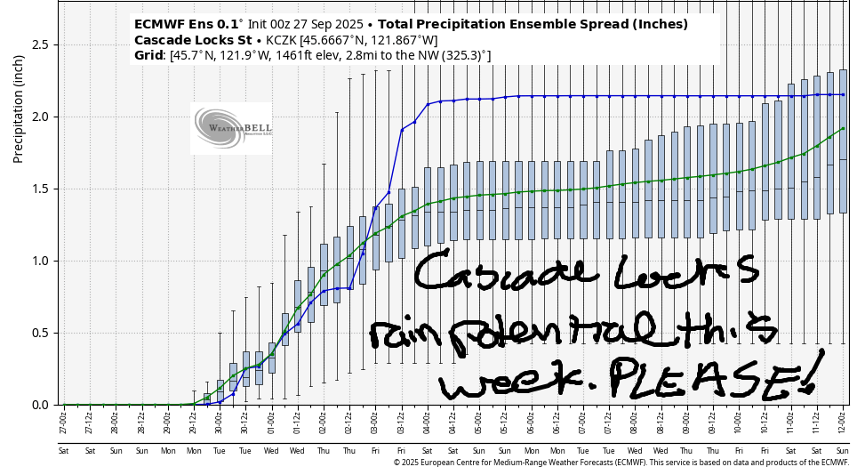
Good morning, neighbors! A couple more days of warm weather are on tap, and then Ma Nature flips the Autumn switch to, well, Autumn. We’re expecting at least a little rain this week with the best chances for a soaker (but not a super-soaker) coming Tuesday evening into Wednesday. Starting Monday, high temps fall below 80. They stay there, allowing you to spend some time outside without sweating your nuts off.
Glenwood this morning
Before we talk rain, let’s talk Glenwood: 34 degrees and sunny there this morning. Next chance of frost in Glenwood comes anytime in the first half of next week if the sky can clear; with 850mb temps below 8C, frost is possible in Glenwood if there’s clear sky, light wind, and low humidity. PREPARE YOURSELF, GLENWOOD!
Today’s Gorge weather forecast
For the rest of the Gorge today, we’ll have a sunny day with temps in the low 80s and low humidity. East wind picks up to 15-20mph between Iwash (dong) Rock and Viento this morning. The wind turns calm early afternoon and then switches to westerly, maybe rising to 15mph from Stevenson to Hood River in the evening, and maybe not. Overnight: 40-something degrees with increasing high clouds.
Sunday’s Gorge weather forecast
Expect a colorful sunrise on Sunday (thankfully the sun is forecast to rise, so we won’t freeze into blocks of ice and explode into ice crystals tomorrow) followed by increasing high clouds. Temps max out in the low 80s. Light wind in the morning rises to west wind at 15-20mph between Stevenson and Rufus in the afternoon, just enough to get the boardheads antsy. More important to do on Sunday: pick the tomatoes ahead of the incoming rain.
Extended Gorge weather forecast
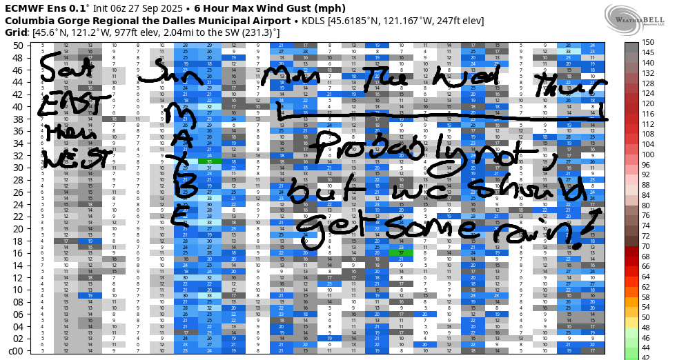
The first in a series of cool, damp, moist, maybe even wet weather systems arrives Monday morning. Moderate rain falls west of Cascade Locks for a few hours. Drizzle then spreads as far east as The Dalles mid-morning. South Wasco: drizzle for you too, but not very much. This system is chilly – the snow level falls to 9000′, and high temps fall to 68F (west), 72F (The Dalles), and 77F (the desert). Cloud cover will be extensive all day long. Wind: calm early and west 20mph east of Mosier in the afternoon. Tuesday looks wetter, as does Wednesday, and showers persist on Thursday. West side highs fall below 70 on Tuesday and stay there for a few days. Out in the desert, highs crest the 70 degree marker, but not by much. Uncertainty increases towards the end of next week, but models suggest temps will stay below 80 for the next couple of weeks. Being that it’s fall, that makes sense. Safe travels. -TATAS
HEY! DON’T STOP READING! Is this community-focused forecast helpful to you? It sure is! It takes me a couple hours a day to write. Please join your friends and neighbors in contributing to keep it going. Venmo: @thegorgeismygym PayPal: twomirrors@gmail.com USPS: Temira / PO Box 841 / Hood River, Oregon 97031 You can test out the forecast subscription for a few days for free by signing up below. Easy! Do it!
MT HOOD SNOW FORECAST

CURRENTLY ON VACATION. WILL RETURN SOMETIME BEFORE THE START OF SKI SEASON AT MEADOWS, TIMBERLINE AND SKIBOWL. SAME GOES FOR THE NORDIC SKIING SEASON AT MEADOWS AND TEACUP!
