

GORGE WIND FORECAST
today’s gorge wind forecast
Hi friends! Westerlies of some sort continue in the Gorge wind forecast for the foreseeable future. Ensembles peg the strongest days of the next seven as Tuesday and Wednesday east of Hood River and Thursday in the Corridor (Hood River area). Between today (Saturday) and Monday, the wind will be fighting instability and other moving pieces. Steadiness and predictability increases with the return of offshore high pressure on Tuesday. Between now and then: westerlies, just gustier and probably under-performing models a bit.
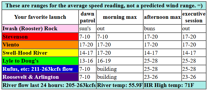
Saturday starts with a low off the coast of BC and a weak system moving towards our region. This setup tends to give us gusty wind with the strongest wind between Lyle and Avery. Gradients at 6am were 30.03/29.98/29.92 with most locations under 10mph despite the solid pressure gradient. We’ll see the entire Gorge, Stevenson to Arlington, rise to 16-19 for a couple hours tmid to late morning. The wind then holds at 17-20 from Stevenson to Viento, drops to 14-17 from Swell to Hood River, and rises to 21-24 from Mosier to Arlington. Models suggest the Mosier-Arlington stretch could top out at 25-28 from mid-afternoon on (remembering that those predictions are for the iWind sensors, and that those tend to read high for location east of Doug’s). I can’t rule out short periods of 27-31, but I’m not going to rule that in for an extended period of time. River flow over the last 24 hours was 205-263kcfs (211-263kcfs at Rufus), river temp is 55.9F, and high temp forecast is 71F for Hood River and 75F for Arlington.

tomorrow’s gorge wind forecast
An offshore low dominates the picture on Sunday. Atmospheric instability makes an appearance. Westerlies back off in response. The day starts with 5-10mph all through the Gorge along with some drizzle west of Cascade Locks and east of The Dalles. Help comes in the form of a synoptic-scale thermal gradient between the west side of Oregon and Montana. This results in 20-23 from Avery to Threemile early afternoon and 22-25 in the evening for that stretch. West of Avery, the wind will be light most of the day. It picks up to 12-15mph from Stevenson to Doug’s mid afternoon. All bets are off if the instability fires off thunderstorms. As a matter of fact, westerlies are likely to under-perform given the instability, so even the forecast above is suspect! High temp: 63F for Hood River and 65F for Arlington with mostly cloudy sky in the morning and partly cloudy sky in the afternoon.
extended Gorge wind forecast
Instability sticks around on Monday, but help comes in the form of late-building offshore high pressure. Morning brings 11-14 from Stevenson to Arlington. Afternoon wind rises to 16-19+ from Stevenson to Mosier, 22-24 from Lyle to Rufus, and 17-20 from Philippi Canyon to Boardman. High temp: 63F for Hood River with mostly cloudy sky in the morning and mostly clear sky in the afternoon.
While the overall setup won’t be completely movement-free starting Tuesday, it’ll be much less active. Offshore high pressure settles in, and moderate NW flow aloft aids our situation. Ensembles have both Tuesday and Wednesday in the 27-31+ range with the strongest wind east of Mosier. The focus shifts back to the Corridor (Hood River area) on Thursday for a solid day of riding close to home. Somewhat lighter, but still windy, wind continues Friday. Ensembles then hint at another round of stronger westerlies through next weekend. That far out, things could change, but with 85% of the ensembles on board, we’re likely to see westerlies of some sort continue. Hope to see you all on the Nch’i Wana today. Have an awesome day!
Was that helpful? I knew it was! Guess what? All of this crucial work – from your personal wind and snow reports to the invaluable TATAS updates – is made possible by my relentless efforts. Maintaining this labor of love isn’t easy. Each daily forecast takes hours. Website hosting, weather model access, and back-end admin work takes time and money. That’s where you come in.
YOUR CONTRIBUTION MAKES A DIFFERENCE
- SUPPORT ACCURATE, HYPER-LOCAL WEATHER FORECASTING
- ENABLE ACCESS FOR ALL, EVEN THOSE WITH LESS MEANS
- SUPPORT A COOL HUMAN WHO WORKS HARD SO YOU CAN PLAY
Take a moment to click one of the buttons below. Donate $19.99 or more (how much does this forecast enhance your life?) and get the email in your inbox. Whether it’s a renewing subscription (auto-renew) or a one-time donation, every contribution makes a real difference. Help me keep this labor of love alive, so we can all continue playing, commuting, and living in the Gorge with peace of mind and the best weather forecasts possible. Thank you!


Hood River, Oregon 97031


JONES BEACH, SAUVIE ISLAND, & COAST FORECAST
Wind northerly unless otherwise indicated. For coast, it’s North/Central/South with the “central” at approximately Florence. Swell forecast from NWS for central coast. Saturday: W10/LTW/N10, W swell 4′ at 10 seconds. Sunday: SW15/S25/S30, W 5′ @ 9. Monday: NW10-15/NNW10-15, LTN, W 6′ @ 10. Jones Saturday: LTW. Sunday: LTW. Monday: 12-15. Sauvie Island Saturday: 11-14. Sunday: W 10-15. Monday: LTW.
BARE BONES HOOD RIVER WEATHER FORECAST
Clouds stick around for most of today. Temps start in the low 50s and rise to the low 70s. Moderate westerlies. No rainbows. Sunday will be mostly cloudy then partly cloudy with a slight chance of a thunderstorm. Temps start in the upper 40s and rise to the low 60s. Light westerlies early. Moderate later. 16% chance of rainbows. Monday will be mostly cloudy then mostly clear with a slight chance of thunderstorms. Temps star in the mid 40s and rise to the low 60s. Moderate westerlies. 14% chance of rainbows.
TEMIRA’S AWESOME TRAVEL ADVISORY SERVICE
HYPERLOCAL WEATHER FORECAST FOR THE COLUMBIA GORGE
THE DALLES, HOOD RIVER, WHITE SALMON, TROUT LAKE, STEVENSON, CASCADE LOCKS, PARKDALE, ODELL, HUSUM, BZ, MILL A, WILLARD, GOLDENDALE, RUFUS, ARLINGTON, boardman

Good morning, neighbors! Lots of clouds are in the forecast for the next several days along with cooler temps than we’ve seen recently. Average high temps for Hood River the next week or so run right around 68 degrees, and we’ll likely be BELOW that for once. Wow. There’s even a bit of drizzle in the forecast for some of us this upcoming week. When I see a forecast like this, I think “gardening”. Actually, I’m thinking “gardening” all the time now because I’m obsessed, but clouds and cool temps make me even more excited to get my hands in the dirt. Hopefully you have access to land for gardening. If not, maybe you can score a plot at one of the local community gardens or talk a church with a lot of unused land and irrigation rights into letting you start a community garden there.
Glenwood and today’s gorge weather forecast
Checking in with our friends in Glenwood first off… 37 degrees there this morning, not frosty for once. Thank the cloud cover for that. Oh, that reminds me. It’s time to thank the sun for rising. I’ll be right back. Okay, I’m back. Sol says hi. High clouds will filter Sol today, all day long, and some mid-level clouds will push inland to Hood River. Even so, we’ll still max out around 70 degrees in the lowlands. West wind picks up to 15-20mph west of Mosier with 25mph or so from Mosier east to Threemile Canyon and 20mph east of there.
(I just led a meditation group for the last 80 minutes, but I’m back now)
tomorrow’s gorge weather forecast
On Sunday… lots of buttocks. No, totally. I just made that up, but why not? Butts are cool. Along with the butts, we’ll have mostly cloudy sky in the morning, partly cloudy sky in the afternoon, and a slight chance of thunder. Drizzle is totally possible west of Wyeth all day and between The Dalles and Amayah’s (the location formerly known as Biggs) as well as South Wasco County between 5am and 11am. Westerlies will be 5-10mph to start. In the afternoon, they rise to 10-15mph west of Avery and 20-25mph east of Avery. High temp: low 60s. Snow level: 5000′ or so.
Monday’s gorge weather forecast
Monday also has a slight chance of thunder. Drizzle continues west of Hood River into the afternoon. Early in the morning, south Wasco and Sherman counties could see a little drizzle too. It won’t be enough to make a difference in soil moisture, but it’ll still be a nice change. Afternoon highs rise to the low 60s. The snow level will be around 4000′ for much of the day, rather low for this time of year. West wind starts at 10-15mph and rises to 15-20mph west of Lyle and 20-25mph east of Lyle.
extended gorge weather forecast
Moving on to Tuesday and Wednesday: slight chance of showers in the west and strong wind east of Hood River. Highs in the low 60s. Cool weather continues through the end of the week with intermittent clouds/sprinkles and continued west wind. Temps aloft will be cool enough to maybe fire off some frost, but cloud cover and west wind will inhibit frost development. We’ll take it day by day, okay? Valuable Advice for Gardeners Inhabiting Neighboring Areas: it doesn’t get much better than this for getting shit to germinate. Get those seeds in the ground and take advantage of the cooler temps, lesser sunshine, and higher humidity. Happy planting. Safe travels. -TATAS
HEY! DON’T STOP READING! Is this community-focused forecast helpful to you? It sure is! It takes me a couple hours a day to write. Please join your friends and neighbors in contributing to keep it going. Venmo: @thegorgeismygym PayPal: twomirrors@gmail.com USPS: Temira / PO Box 841 / Hood River, Oregon 97031 You can test out the forecast subscription for a few days for free by signing up below. Easy! Do it!

One response to “Saturday Gorge wind forecast: plenty of west wind for y’all. Cooler temps next week.”
Totally enjoy your posts!