

GORGE WIND FORECAST
today’s gorge wind forecast
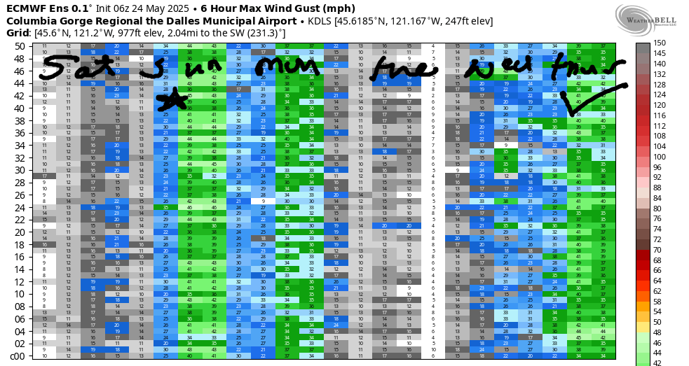
Hi friends! In a not-so-awesome twist, the entire UW Atmospheric Sciences website is down this morning. As that’s where I get the majority of my information for the Gorge wind forecast, I’m relying on backup models, models whose quirks I don’t understand. That’s an intellectual way of saying that this forecast is unlikely to be as accurate as usual today. Hopefully the UW website is back up soon – I’ve never seen it go down for more than a day. Fingers crossed! (Naturally those models came back up just as I finished writing this – it looks okay to me.)
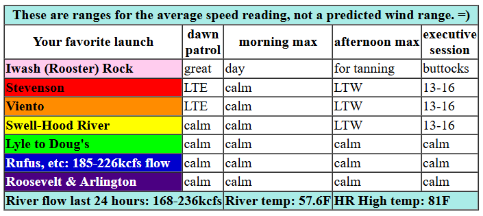
So, on to the forecast using the backups… This morning (Saturday) started with pressures of 30.07/30.06/30.05 for nearly-flat gradients. Wind speeds agree with the gradients – it’s light/variable out there with easterlies at 5mph on the west side and westerlies at less than 10mph on the east side. For most of the day, wind will remain calm. Models hint at just enough thermal support this afternoon for maybe 13-16 from Stevenson to Hood River after 5pm. River flow over the last 24 hours was 168-236kcfs (185-226kcfs at Rufus), river temp is 57.6F, and high temp forecast is 81F. Nice day to do a not-wind-sport!

tomorrow’s gorge wind forecast
A cold front approaches the coast on Sunday and helps hold temps down on the west side. Out in the desert, Pasco’s forecast high is 92 degrees. While we won’t have the support of offshore high pressure (that’s what drives the really nuking days), we’ll have that thermal gradient. Unfortunately, thanks to the offshore trough, we’ll likely have southerly wind aloft, and this will result in instability, especially east of The Dalles, and that might just destabilize our wind. Don’t forget about the CGW2 swap meet at Lot 1 on Sunday morning! Early wind will be 14-17 from Stevenson to Hood River with less out east. The Euro suggests the wind will rise by early afternoon to 26-29 from Stevenson to Rufus. Give it a couple more hours, and Mosier-Arlington will rise to 30-33. That approaching front is likely to result in the west side, Stevenson to Hood River, falling to gusty 20-23 or less in the afternoon (Viento will over-perform as usual). Late in the day, Threemile and Boardman join at 30mph or so. High temp: 77F with partly cloudy sky on the west side and high clouds out east. Speaking of clouds, if they over-perform near Swell, you’ll need to head east for the strongest wind.
extended Gorge wind forecast
That weather system swings through on Monday morning with a bit of drizzle for areas west of The Dalles. As the day progresses, high pressure builds offshore. This starts the day with 12-15mph from Stevenson to Mosier, 7-10mph from Lyle to Doug’s, and 19-22 from Rufus to Boardman. West wind builds to 25-28+ from Maryhill to Threemile in the morning and fills backwards towards Hood River in the afternoon. Timing of clearing will determine wind quality; the earlier it burns off, the steadier the wind will be in the Corridor (Swell to Hood River). High temp: 70F in Hood River and 80F in the desert with morning clouds and afternoon sun with increasing high clouds.
Looking at the extended forecast in the ensembles, which are working today: Tuesday brings light westerlies, perhaps low to mid teens near Swell. Wednesday brings east wind and temps pushing towards 90. Models call for cooling of some sort (the amplitude of the cooling is up in the air still) and accompanying stronger westerlies next Thursday. Alrighty – let’s leave it there for now and all cross our fingers that the UW gets that website back up by tomorrow morning. See you on the Nch’i Wana!
Was that helpful? I knew it was! Guess what? All of this crucial work – from your personal wind and snow reports to the invaluable TATAS updates – is made possible by my relentless efforts. Maintaining this labor of love isn’t easy. Each daily forecast takes hours. Website hosting, weather model access, and back-end admin work takes time and money. That’s where you come in.
YOUR CONTRIBUTION MAKES A DIFFERENCE
- SUPPORT ACCURATE, HYPER-LOCAL WEATHER FORECASTING
- ENABLE ACCESS FOR ALL, EVEN THOSE WITH LESS MEANS
- SUPPORT A COOL HUMAN WHO WORKS HARD SO YOU CAN PLAY
Take a moment to click one of the buttons below. Donate $19.99 or more (how much does this forecast enhance your life?) and get the email in your inbox. Whether it’s a renewing subscription (auto-renew) or a one-time donation, every contribution makes a real difference. Help me keep this labor of love alive, so we can all continue playing, commuting, and living in the Gorge with peace of mind and the best weather forecasts possible. Thank you!


Hood River, Oregon 97031


JONES BEACH, SAUVIE ISLAND, & COAST FORECAST
Wind northerly unless otherwise indicated. For coast, it’s North/Central/South with the “central” at approximately Florence. Swell forecast from NWS for central coast. Jones: westerly unless otherwise stated. Sauvie Island: northerly unless otherwise stated. All my usual weather models are down this morning, so I’ll just leave you with the forecast for the coast from NWS. Also, Jones, but this is not a great guess… Saturday: 15-18. Sunday: 10-13. Monday: 16-19.
BARE BONES HOOD RIVER WEATHER FORECAST
Sunshine all day with a few high clouds. Temps start in the mid 40s and rise to the low 80s. Calm wind early. Moderate westerlies later. No rainbows. Sunday will be partly to mostly cloudy to start and cloudy later. Temps start in the low 50s and rise to the upper 70s. Moderate westerlies early. Strong westerlies later. 1% chance of rainbows. Monday will be cloudy then partly cloudy with intermittent showers into early afternoon. Temps start in the low 50s and rise to 70 or so. Moderate westerlies in the morning. Stronger later. 99% chance of rainbows.
TEMIRA’S AWESOME TRAVEL ADVISORY SERVICE – SATURDAY 5/24
HYPERLOCAL WEATHER FORECAST FOR THE COLUMBIA GORGE
THE DALLES, HOOD RIVER, WHITE SALMON, TROUT LAKE, STEVENSON, CASCADE LOCKS, PARKDALE, ODELL, HUSUM, BZ, MILL A, WILLARD, GOLDENDALE, RUFUS, ARLINGTON, boardman

Good morning, friends! It’s yet another spectacular morning in the Gorge: blue sky, glassy river, gratitude for the privilege of living here. Oh, and the sun came up again this morning, so we didn’t freeze into blocks of ice last night, and the sun didn’t go supernova last night, so we didn’t burn into crisps overnight. Miracles continue…
glenwood’s start this morning
Today’s second miracle (after the sun rising) is that I managed a forecast at all with the UW atmospheric sciences website (and most of my models) down. But Glenwood’s morning temp comes from a NWS website: it was 37 degrees there with clear sky and lots of people pissing off the deck. Yes, I’m talking to you. I have cameras that detect deck-based peeing.
today’s gorge weather forecast
We’ll have a sunny, brilliant day today with temps about 8 degrees above normal. Normal for Hood River today is 72 degrees. Normal for me is 97.3 degrees. That’s oral. I don’t know what my normal anal temp is, but if you wait five minutes, I can let you know. KIDDING, JUST KIDDING – I’M NOT STICKING ANYTHING UP MY BUTT FOR YOU! That would be a boundary violation, and I just don’t do those. Other weather news today: calm wind this morning. Westerlies rise to 10-15mph between Stevenson and Hood River this afternoon. Speaking of wind … Gary’s out there paddling his pumpkin down the Nch’i Wana. I just looked, and he’s currently at Portland Sailing Center along Marine Drive in Portland. You too can stay glued to your computer watching Gary progress down the Big River, but you’ll have more fun if you get outside and do something in the woods. I promise.
sunday’s gorge weather forecast
Back to the Gorge weather: We’ll cool off a few degrees on Sunday as a weather system approaches, but we’ll still be about 5 degrees above normal. Add in clouds for the west side most of the day and increasing clouds for everyone in the afternoon. Areas east of The Dalles are likely to see some rain overnight, and the Cascades could pick up a few sprinkles. Westerlies start at 15mph west of Mosier with light wind to the east. Afternoon wind rises to 30mph everywhere resulting in the boardhead wind Johnnies losing their shit and scrambling to ride the river unicorns. You can include me in that chaos. Riding river unicorns is high on my list of ways to access conditional joy. High temp: 77 degrees for Hood River.
memorial day gorge weather forecast
Drizzle moves in after midnight Sunday and stretches intermittently to The Dalles until noon or so Memorial Day. This knocks temps down to 70 on the west side and lets them climb to 80 in the desert, where it will be mostly clear midday with high clouds later. West wind will be 10-15mph west of The Dalles in the morning with 15-25 mph east of The Dalles. Afternoon wind rises to 25-30mph everywhere. Given the combo of sun breaks, clouds, drizzle, and wind, rainbow chances are 99% west of The Dalles all morning long.
extended gorge weather forecast
Warmer, less windy weather is forecast Tuesday. On Wednesday, we’ll have our hottest day of the year so far: upper 80s. You can find me in the cold storage unit at McCurdy Farms. I should probably tell Craig before I go in there so I don’t startle him. Wind will turn easterly and Wednesday with 20+ mph near Stevenson and Iwash Rock, the biggest cock of all the rocks. On Thursday, cooler weather is in the cards (we’re not sure yet how cool) as is strong west wind (we’re not sure yet how strong). Uncertainty increases after that, but there’s some sign of temps warming again into next weekend. That is all for now. I need to get out there and do some shit before it gets too hot. Remember that anything over 75 degrees is too hot for TATAS. They melt in the sun above that temp, but it should be noted that TATAS melts in your mouth at all temps. Safe travels. -TATAS
HEY! DON’T STOP READING! Is this community-focused forecast helpful to you? It sure is! It takes me a couple hours a day to write. Please join your friends and neighbors in contributing to keep it going. Venmo: @thegorgeismygym PayPal: twomirrors@gmail.com USPS: Temira / PO Box 841 / Hood River, Oregon 97031 You can test out the forecast subscription for a few days for free by signing up below. Easy! Do it!
