

GORGE WIND FORECAST
If you’re still seeing yesterday’s and it’s after 9am, try opening this in an incognito window
today’s gorge wind forecast
Hi friends! Interesting setup today as a low speeds towards Vancouver Island and we land directly in the sting jet side of things. It’s possible we could see strong to very strong desert wind late today (definitely overnight). That’s about it for the next few days – lingering westerlies early tomorrow morning fade quickly. Monday turns easterly, but probably not strong enough, and the next chance for anything is next Wednesday. Other fun things to do in the meantime: play in the snow tomorrow and Monday on Mt. Hood, and help the HRATS with a trail work party (meet at Family Man) on Sunday morning starting at 9am.
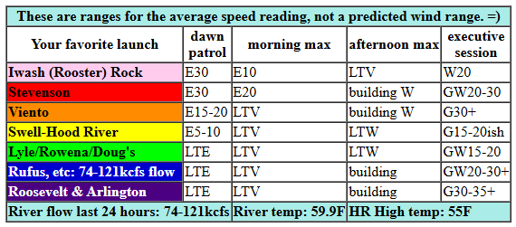
Looking at Saturday morning, we have pressures of 29.67/29.77/29.78. Iwash (Rooster) and Stevenson were both reading 30mph early this morning, and Viento was reading 15-20mph. The east wind will fade quickly: models have Stevenson down to 20mph by 11am and Iwash light and variable by that time. Iwash switches to westerly first: very gusty 20mph. Rain moves in and spreads all the way into the desert until 2pm or so before retreating back to Lyle (or so).
After the rain retreats, the wind picks up out east behind the front. Gusty 30-35mph from Avery (maybe) to Boardman (definitely) which leaves us with the Arlington to Boardman stretch as most likely and the Avery to Rufus stretch as a maybe. Viento should pick up to 30+ for a period, Stevenson to 20-30mph. The Hatch-Doug’s zone is questionable with this setup, especially given the continuing rain. Looking at the Euro ensemble, we have nearly 100% chance for gusty 34kts/39mph+ out in the desert this afternoon, so it’s high probability. Hopefully the arrival doesn’t get delayed until after dark! River flow over the last 24 hours was 74-121 kcfs, river temp is 59.9F, and high temp forecast is 55F for Hood River and 62F in the desert.
RIVER FLOW FOR SITES BETWEEN AVERY (EAST OF THE DALLES) AND RUFUS: CLICK HERE FOR JOHN DAY DAM FLOW.
RIVER FLOW FOR SITES BETWEEN STEVENSON AND DOUG’S BEACH (WEST OF THE DALLES): CLICK HERE FOR THE DALLES DAM FLOW

tomorrow’s gorge wind forecast
Lingering westerlies Sunday morning quickly fade. They’ll turn calm midday and return at 10-13mph or so after 5pm, when we’re also expecting rain. Not much going on, eh? High temp: 51F for Hood River and 54F out in the desert.
extended Gorge wind forecast
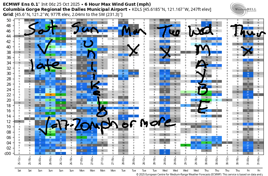
Monday starts calm and turns easterly at 20mph in the usual spots in the afternoon. High temp: 53F. Not much happens on Tuesday – models have calm wind (at least for now). A weather system swings through in that Tuesday/Wednesday time period and gives us the possibility of some westerlies on Wednesday. Models then revert to “calmish” for Thursday. So, your best chance is late today, way out east. Hopefully that works with your schedule, cuz it does not work with mine. See you on the Nch’i Wana!
MT HOOD SNOW FORECAST

Hi skiers and snowboarders! First big snowfall of the year!!! An offshore low taps into an atmospheric river and strong wind aloft and sends lots of snow above 4000′ through Sunday afternoon. A beautiful Monday – clear sky, low freezing level, and relatively light wind might just make for a good first play day in the snow. After this storm, there isn’t much in sight snow-wise, so get it if you’re excited out it!
Saturday kicks off cloudy with rain. This switches to snow at 5000′ early afternoon and continues overnight with conditions becoming rather blizzardy overnight. The snow level will be 5500′. early, 4500′ this afternoon, and 3500′ after midnight. About 0.6” rain is forecast before the switchover. After 2pm, we’ll pick up about 1.0” water equivalent overnight for 8-11” increasingly dry snow. We could see snowfall exceed that thanks to orographic effects from the wind: SSW 15-30 this morning rises to WSW 60-65 this afternoon and W 40 after midnight.
Sunday sees a brief break in the snowfall early (maybe even a couple hours of clear sky, or just orographic flurries) before the next system arrives mid-morning. The snow level will be 3500′ all day, and the freezing level will fall to 2500-3000′ overnight. During the day, after 11am, we’re expecting about 0.6” WE for 5-6” new snow. Overnight: 0.1” to 0.3” for 1-3” more. Wind will be W 40 early but will quickly switch to SW 15-20 in the afternoon and W 15-20 in the evening.
Monday kicks off clear and turns high overcast. Rain (sad) arrives overnight. The snow level will be 2500-3000′ early, 4000′ in the afternoon, and 10,000′ after midnight. About 0.2” drizzle is forecast overnight. Wind: W 15 in the morning, S 15 in the afternoon, and SW 20-30 after midnight.
Tuesday will be dry. Another round of rain is forecast on Wednesday. Models have a “maybe” on a Pineapple Express next weekend (about 50% chance and dropping), so if you want some snow time, get it now! See you in the white room and on the skategroom!
Was that helpful? I knew it was! Guess what? All of this crucial work – from your personal wind and snow reports to the invaluable TATAS updates – is made possible by my relentless efforts. Maintaining this labor of love isn’t easy. Each daily forecast takes hours. Website hosting, weather model access, and back-end admin work takes time and money. That’s where you come in.
YOUR CONTRIBUTION MAKES A DIFFERENCE
- SUPPORT ACCURATE, HYPER-LOCAL WEATHER FORECASTING
- ENABLE ACCESS FOR ALL, EVEN THOSE WITH LESS MEANS
- SUPPORT A COOL HUMAN WHO WORKS HARD SO YOU CAN PLAY
Take a moment to click one of the buttons below. Donate $19.99 or more (how much does this forecast enhance your life?) and get the email in your inbox. Whether it’s a renewing subscription (auto-renew) or a one-time donation, every contribution makes a real difference. Help me keep this labor of love alive, so we can all continue playing, commuting, and living in the Gorge with peace of mind and the best weather forecasts possible. Thank you!


Hood River, Oregon 97031


BARE BONES HOOD RIVER WEATHER FORECAST
Cloudy today with rain after 11. Temps start in the low 40s and rise to the mid 50s. Light wind early. Moderately strong westerlies late. 18% chance of rainbows. Sunday will be mostly cloudy with dry weather during the day and rain overnight. Temps start in the upper 30s and rise to the low 50s. Light westerlies. No rainbows. Monday will be cloudy then partly cloudy with rain early. Temps start in the upper 30s and rise to the low 50s. Calm wind then light easterlies. 39% chance of rainbows.
TEMIRA’S AWESOME TRAVEL ADVISORY SERVICE
HYPERLOCAL WEATHER FORECAST FOR THE COLUMBIA GORGE
THE DALLES, HOOD RIVER, WHITE SALMON, TROUT LAKE, STEVENSON, CASCADE LOCKS, PARKDALE, ODELL, HUSUM, BZ, MILL A, WILLARD, GOLDENDALE, RUFUS, ARLINGTON, boardman
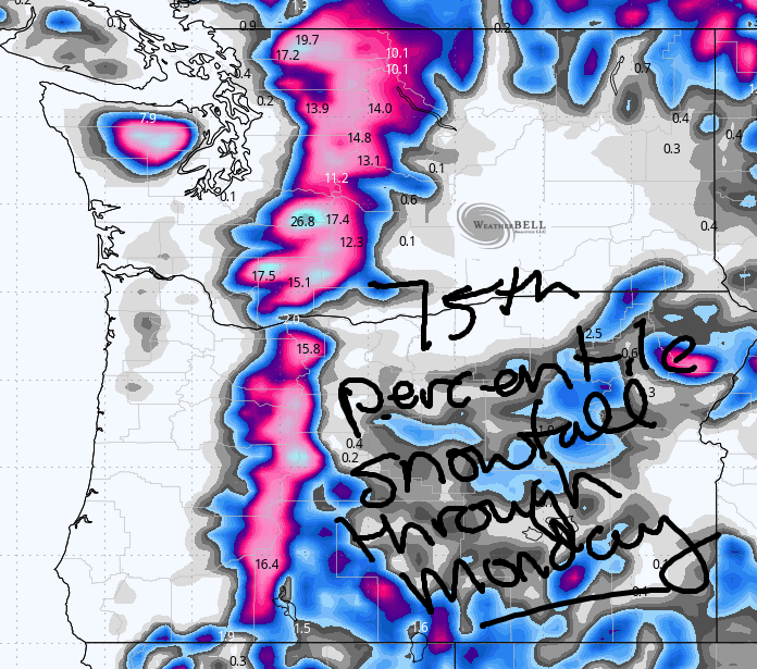
Good morning, neighbors! Wet weather is in the cards today and shall remain in the cards through early Monday morning. A short break in the moisture is likely Monday and Tuesday, and then we rack up a bit more rain on Wednesday. Models are still contemplating another round of heavy rain next weekend, but the likelihood has dropped from about 80% to perhaps 40%. Up in the mountains, lots of snow is forecast this weekend above 4000′. Along with the snow: blizzardy, or at least really wind conditions are forecast Saturday night into early Sunday morning. Definitely avoid the passes in that period.
Glenwood this morning
Looking at Glenwood this morning, we see cold! Again! 32 degrees! 32 degrees and cloudy. Wait, that’s getting damn close to snowy! Wait, it’s raining at my house. Is it snowing or icing at someone’s house this morning????
Today’s Gorge weather forecast
For all of us today: rain! You’ve been begging for it, so now enjoy it! Let’s enjoy rain! By 11am, the rain extends all the way to Arlington, and it quickly turns heavy in the western Gorge and moderate to the east and in south Wasco and Sherman counties, mentioned because they are often dry. But not today! Mid afternoon sees the rain retreat to the zones west of The Dalles (plus Goldendale and Centerville – they stay wet) with heavy rain persisting on and off west of Mosier overnight. Wind: east 30mph near Iwash (schlong) Rock and Stevenson this morning, light/variable this afternoon, and strong from mid to late afternoon on. Strong wind will be west of Hood River and east of The Dalles with gusty over 40mph likely east of Rufus and especially east of Arlington. High temps in the lowlands: 55F to the west and 61F to the east. Mountains: the snow level drops to 4000′ this afternoon and as low as 3000′ overnight along with moderate snowfall and very strong wind. This is NOT the time to be driving the passes – visibility will be limited, snow will be piling up, and tree branches will be falling.
Sunday’s Gorge weather forecast
Rain persists all through Sunday west of Wyeth. Starting around 11am, rain pushes as far east as Biggs and also into South Wasco County. Heavy rain makes its way east during the day and completely soaks everyone all the way to Idaho. Expect hydroplaney conditions. At least it won’t be wind: moderate westerlies early quickly turn calm and then return as light westerlies in the evening. High temps; just 51F to the west and 55F to the east. Up in the mountains: a brief break in snowfall in the morning gives way to heavy snow and 20mph wind from 11am on through Sunday night. Up to a foot of snow is forecast.
Extended Gorge weather forecast
Monday’s weather: potentially frosty in our higher locations east of the Cascade Crest, where the day starts clear. To the west, the day starts cloudy. Drizzle early gives way to dry weather after sunrise for the east side, after 11am for Hood River, and after 2pm in Cascade Locks. High temps will be 53F to the west and 56F from The Dalles eastward. Wind: calm early. East 20mph in the usual east wind spots (Wanker Rock, Cascade Locks, Home Valley) in the afternoon. Tuesday: drizzly early, dry later, and calm. Wednesday: wet for a period of time. Thursday; probably dry. Halloween: dry early and wet in the afternoon west of The Dalles. I wonder if I can repurpose my clear onesie from the naked bike ride and go as a naked bike rider? Probably not. I guess I’ll be Cookie Monster. Safe travels. -TATAS
HEY! DON’T STOP READING! Is this community-focused forecast helpful to you? It sure is! It takes me a couple hours a day to write. Please join your friends and neighbors in contributing to keep it going. Venmo: @thegorgeismygym PayPal: twomirrors@gmail.com USPS: Temira / PO Box 841 / Hood River, Oregon 97031 You can test out the forecast subscription for a few days for free by signing up below. Easy! Do it!
JONES BEACH, SAUVIE ISLAND, & COAST FORECAST
ON WINTER VACATION
