

GORGE WIND FORECAST
today’s gorge wind forecast
Hi friends! Westerlies back off for the next several days as various factors conspire to squash gradients. A warming trend starting tomorrow (Sunday) and ending Tuesday sets us up cooldown-related wind Wednesday. It probably won’t quite be The Cooldown You Were Looking For, but it should be enough to nudge westerlies up. Beyond that, there’s really too much uncertainty to put out an accurate Gorge wind forecast, so we’ll leave it at the Tuesday-Wednesday time frame today. Before I forget… please contribute to Bart’s GoFundMe if you haven’t already. It’s been so heartwarming to see so many of my subscribers on the contributor list. Keep it up, folks. Support our fav wind forecaster as he rebuilds from the Rowena Fire.
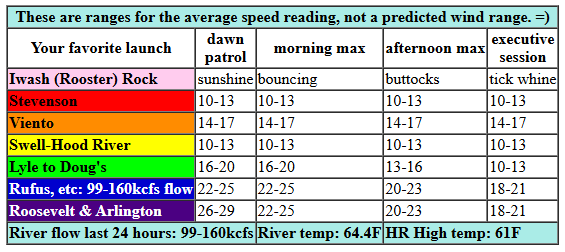
Okay. Saturday’s wind. Pressures started off at 30.03/29.95/29.88 for gradients of 0.08/0.07. Westerlies were generally in the 10-13mph range west of Lyle and 17-20mph east of Lyle with upper 20s at Arlington. Another weather system is headed our way today with more rain for areas west of The Dalles. Expect the Stevenson-Doug’s zone (Rowena has reopened, btw) to hover under 15mph, or maybe under 10mph, all day long. Between Avery and Arlington, we’ll see peak wind this morning with a slow fade to 20-23mph this afternoon and 18-21mph late afternoon on. Remember that this forecast predicts what the iWind/iKite sensors will read. 20-23mph on those eastern Gorge sensors is about the same as 15-18mph on the Swell sensor. River flow over the last 24 hours was 99-160kcfs, river temp is 64.4F, and high temp forecast is 61F for Hood River and 64F for Arlington with clouds in the west and increasing high clouds out east.
RIVER FLOW FOR SITES BETWEEN AVERY (EAST OF THE DALLES) AND RUFUS: CLICK HERE FOR JOHN DAY DAM FLOW.
RIVER FLOW FOR SITES BETWEEN STEVENSON AND DOUG’S BEACH (WEST OF THE DALLES): CLICK HERE FOR THE DALLES DAM FLOW

tomorrow’s gorge wind forecast
Sunday starts off with very light wind, perfect for the swap meet at Windance! As the cool trough shifts east and moderate high pressure builds offshore, we’ll see westerlies bump up. That said, afternoon instability is possible, and that may decrease wind strength and consistency. We could even see some showers and/or a thunderstorm! Caveats aside: if we avoid the instability, midday wind looks like 16-19 from Stevenson to Doug’s. Afternoon: 13-16 from Stevenson to Hood River with 19-22 from Mosier to Avery. East of Avery, the wind will be less than 10mph all day long. High temp: 73F for Hood River.
extended Gorge wind forecast
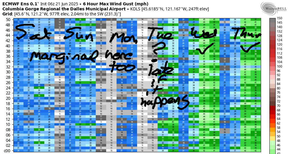
Monday’s right on the edge for enough/not enough. Opening play is 10-13mph from Stevenson to Arlington. Midday wind rises to 16-19mph from Mosier to Rufus with 13-16 from Stevenson to Hood River. Areas east of Rufus will be 10-13mph all day long. Afternoon brings 19-21 from Mosier to Rufus with 10-13mph east of Rufus and west of Mosier. High temp: 83F and partly cloudy on the west side and 84F and sunny out east. Tuesday starts out light. If models are correct about an approaching trough of cool air, we’ll see the wind jump in the afternoon. So far this season, this scenario has drastically under-performed models, so I’m not expecting strong wind. It’s likely we’ll see enough, low 20s, perhaps, to get many of us on the water. Significant uncertainty exists from Wednesday on. In the lower-temp scenario, we have the potential for a moderately strong to strong day both Wednesday and Thursday. But there’s no way to make a call yet. Wait to pencil anything in until the models come to better agreement. Canada: I see you. I’ll get you that Canada Day weekend forecast as soon as I can! Stay warm today, everyone. I’ll see you on the Nch’i Wana!
Was that helpful? I knew it was! Guess what? All of this crucial work – from your personal wind and snow reports to the invaluable TATAS updates – is made possible by my relentless efforts. Maintaining this labor of love isn’t easy. Each daily forecast takes hours. Website hosting, weather model access, and back-end admin work takes time and money. That’s where you come in.
YOUR CONTRIBUTION MAKES A DIFFERENCE
- SUPPORT ACCURATE, HYPER-LOCAL WEATHER FORECASTING
- ENABLE ACCESS FOR ALL, EVEN THOSE WITH LESS MEANS
- SUPPORT A COOL HUMAN WHO WORKS HARD SO YOU CAN PLAY
Take a moment to click one of the buttons below. Donate $19.99 or more (how much does this forecast enhance your life?) and get the email in your inbox. Whether it’s a renewing subscription (auto-renew) or a one-time donation, every contribution makes a real difference. Help me keep this labor of love alive, so we can all continue playing, commuting, and living in the Gorge with peace of mind and the best weather forecasts possible. Thank you!


Hood River, Oregon 97031


JONES BEACH, SAUVIE ISLAND, & COAST FORECAST
Wind northerly unless otherwise indicated. For coast, it’s North/Central/South with the “central” at approximately Florence. Swell forecast from NWS for central coast. Jones: westerly unless otherwise stated. Sauvie Island: northerly unless otherwise stated. Saturday: W10-15/W15/LTNW, W swell 7′ at 9 seconds. Sunday: LTNW/NW10/N20-25, NW 6′ @ 9. Monday: NW5-10/N15-20/N25-30, N 5′ @ 11. Jones Saturday: LTW. Sunday: 19-22. Monday: 16-19. Sauvie Island Saturday: 10-13. Sunday: 11-14 > 5pm. Monday: 10-13 > 5pm.
BARE BONES HOOD RIVER WEATHER FORECAST
Clouds today with rain from mid-morning on. Temps start in the low 40s and rise to the low 50s. Calm wind. 11% chance of rainbows. Thursday will be showery all day. Temps start in the upper 30s and rise to the upper 40s. Moderate westerlies. 99.99% chance of rainbows. Friday will be High overcast and dry in the morning with rain in the afternoon. Temps start in the low-mid 30s and rise to the mid 40s. Light easterlies. 4% chance of rainbows.
TEMIRA’S AWESOME TRAVEL ADVISORY SERVICE
HYPERLOCAL WEATHER FORECAST FOR THE COLUMBIA GORGE
THE DALLES, HOOD RIVER, WHITE SALMON, TROUT LAKE, STEVENSON, CASCADE LOCKS, PARKDALE, ODELL, HUSUM, BZ, MILL A, WILLARD, GOLDENDALE, RUFUS, ARLINGTON, boardman
Good morning, neighbors! Chilly weather continues today (I’m currently wearing a purple hoodie and wrapped in a purple blanket due to cold) as an unseasonably cold trough settles in atop us. Those of us west of Rufus receive another round of rain today. There’s some possibility of instability-driven showers tomorrow. After that: no measurable rain is forecast in Cherry Land for the next 10-14 days. Temps warm up too. And then cool off. And then warm up.
Saturday’s Gorge weather forecast and Glenwood’s start to the day
Saturday’s starting off seasonably chilly with temps in the low 50s. In Glenwood, it’s 42 degrees thanks to cloudy sky – were it clear, Glenwood would be sub-freezing with 850mb temps at 0C. Glenwood, you are lucky. Up at Timberline lodge, it’s 32 degrees with 4” of new snow on the ground (per T-Line’s report) and more snow on the way. Today’s snow level: 4500′ early and 6000′ later, so maybe skip that high-mountain hike.
Rainfall picks up mid-morning today (Saturday) as a weather system swings in from the northwest like a weather system thinking it’s fall, not summer. Yesterday I thought it was summer, not fall, and wore shorts. I was cold. I will not make that mistake today, and neither should you. Moderate to heavy rain falls west of Hood River from 11am to 2pm or so, and light rain extends all the way to Biggs with that round of moisture. Light drizzle continues as far west as The Dalles and also into south Wasco County into late afternoon. Wind west of The Dalles will be 10mph or less all day. East of The Dalles, we’ll see 20-25mph this morning and 20mph this afternoon. High temps only make it into the low 60s today.
yesterday’s new record low-high!!!
Speaking of high temps… in very exciting news, Hood River set a record yesterday. A record low-high, that is. 57 degrees – that blew away the old record of 61 degrees. Today’s record low-high is 57. That’s going to be hard to beat, but anything is possible. Go cold!
sunday’s gorge weather forecast
While we don’t have any weather systems dragging in additional rain on Sunday, we can’t rule out some instability-driven afternoon showers between Hood River and Rufus. No promises either way, but I can make a suggestion: if you’re feeling unstable, take a hint from Ma Nature and take a shower to distract yourself! The west side starts cloudy. The east side starts mostly cloudy. Everyone finishes partly cloudy. After a 50ish degree start, temps warm to the low 70s. Wind will be less than 10mph everywhere in the morning. Westerlies pick up to 15-20mph in the afternoon between Stevenson and The Dalles with lighter wind to the east.
extended gorge weather forecast
This chilly wintry tomfoolery ends on Monday as forecast highs return to your regularly scheduled 80ish degrees. Sunshine also returns. Wind will be 10mph between Stevenson and Arlington to start the day. Afternoon wind will be 10-15mph from Stevenson to Hood River with 20mph between Mosier and Rufus with 10-15mph east of Rufus. Temps peak on Tuesday with 85-90 degrees for The Dalles. Model agreement is pretty good Wednesday through Friday with 75 degrees and breezy conditions. After that, uncertainty increases, so you’ll have to wait for your Canada Day Weekend forecast. Hopefully that forecast includes Canadians coming to visit bearing Hawkins Cheezies and Coffee Crisp candy bars. If you don’t know what these things are, it’s time to learn. They are the best of all the snack foods. Safe travels. -TATAS
HEY! DON’T STOP READING! Is this community-focused forecast helpful to you? It sure is! It takes me a couple hours a day to write. Please join your friends and neighbors in contributing to keep it going. Venmo: @thegorgeismygym PayPal: twomirrors@gmail.com USPS: Temira / PO Box 841 / Hood River, Oregon 97031 You can test out the forecast subscription for a few days for free by signing up below. Easy! Do it!

One response to “Saturday Gorge wind forecast: maybe just enough? TATAS weather: chilly and rainy!”
Several years ago your blog contained an article about overtaxing yourself while training hard to improve your SUP paddling.
I cannot find that entry and am wondering if it is archived somewhere else. If so, would you be willing to share the article again?
As you might guess, this year I am struggling with a similar episode. It has been almost 3 months since I last felt “normal”. I would love to reread your blog entry on this kind of overreaching, if possible.
Thank you for reading this query and for publishing so much useful info, even though I can’t directly benefit from the weather forecasts due to living about 1200 miles away. The detailed micro-forecasts exemplify what outdoor enthusiasts need!