

GORGE WIND FORECAST
If you’re still seeing yesterday’s and it’s after 9am, try opening this in an incognito window
today’s gorge wind forecast
Hi friends! Instability and associated uncertainty continue for the next few days. That said, decent westerlies are likely both today (Saturday) and tomorrow. Monday is a big question mark thanks to an afternoon weather feature. Tuesday looks cool, showery, and has the potential for low 20s out east, as do next Wednesday and Thursday. Beyond that, uncertainty is high in the ensembles, and agreement is low; there’s no way to say as of now what will happen!
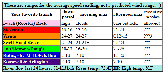
Saturday started off with marine clouds on the west side, convective debris everywhere else, and these pressures: 29.90/29.80/29.80. That’s 0.10 (PDX-DLS) and nothing out east. Models suggest 21-24mph this morning from Viento to the White Salmon Bridge with 17-20mph in Mosier. By late morning, the wind fills in at 21-24mph from Stevenson to Mosier with 11-14mph from Lyle to Doug’s. It’s possible the lingering marine clouds could make for stronger wind near the Hatch. Sometime mid-afternoon, an impulse moves in and destabilizes the atmosphere resulting in thunderstorm potential. If this happens, all bets are off. If not, models have us with 23-26mph from Stevenson to Doug’s late afternoon with 17-20mph at Avery. Rufus joins at 23-26mph after 5pm, assuming all heck hasn’t broken loose. River flow over the last 24 hours was 71-113kcfs, river temp is 73.4F (poor salmon), and high temp forecast is 81F for Hood River and 90F out in the desert.
RIVER FLOW FOR SITES BETWEEN AVERY (EAST OF THE DALLES) AND RUFUS: CLICK HERE FOR JOHN DAY DAM FLOW.
RIVER FLOW FOR SITES BETWEEN STEVENSON AND DOUG’S BEACH (WEST OF THE DALLES): CLICK HERE FOR THE DALLES DAM FLOW

tomorrow’s gorge wind forecast
Sunday starts with the possibility of a few lingering instability-driven showers, and it also starts with a solid marine layer. That’ll help stabilize the low levels and give us some wind. Indeed, models suggest 20-23mph to start all the way from Viento to Boardman. Stevenson, under the marine clouds, will probably be 13-16mph. The wind holds for a few hours. It then dips to 18-21mph between Stevenson and Hood River and rises to 25-28mph from Mosier to Doug’s with 27-30mph on the iWind/iKite sensors between Maryhill and Arlington. Remember that those sensors read high compared to the sensor at Swell; 27-30mph out east is more like 19-22mph at Swell. High temp: 77F for Hood River and 85F at Rufus.
extended Gorge wind forecast
On Monday, a low settles in off the coast or potentially inland. This turns things cooler and showery. Models still have us with 17-20mph from Viento to the Hatch in the morning and 17-20mph from Viento to Rufus by early afternoon. An impulse/low moving S to N from eastern Oregon has the potential to drive the wind into the upper 20s or more near Rufus mid to late afternoon, but it could also destabilize things enough to shut the wind down. We’ll keep a close eye on this.
A cool, showery pattern on Tuesday gives us less wind, maybe 17-20mph east of The Dalles and even less on the west side. Slightly stronger wind is possible on Wednesday, but there’s not much agreement in the ensembles. Beyond that, uncertainty rises, and making a reliable prediction becomes impossible. So I’ll leave it there for now. Hope to see you on the Nch’i Wana today. Get it this morning or early afternoon for most reliable results!
Was that helpful? I knew it was! Guess what? All of this crucial work – from your personal wind and snow reports to the invaluable TATAS updates – is made possible by my relentless efforts. Maintaining this labor of love isn’t easy. Each daily forecast takes hours. Website hosting, weather model access, and back-end admin work takes time and money. That’s where you come in.
YOUR CONTRIBUTION MAKES A DIFFERENCE
- SUPPORT ACCURATE, HYPER-LOCAL WEATHER FORECASTING
- ENABLE ACCESS FOR ALL, EVEN THOSE WITH LESS MEANS
- SUPPORT A COOL HUMAN WHO WORKS HARD SO YOU CAN PLAY
Take a moment to click one of the buttons below. Donate $19.99 or more (how much does this forecast enhance your life?) and get the email in your inbox. Whether it’s a renewing subscription (auto-renew) or a one-time donation, every contribution makes a real difference. Help me keep this labor of love alive, so we can all continue playing, commuting, and living in the Gorge with peace of mind and the best weather forecasts possible. Thank you!


Hood River, Oregon 97031


JONES BEACH, SAUVIE ISLAND, & COAST FORECAST
Wind northerly unless otherwise indicated. For coast, it’s North/Central/South with the “central” at approximately Florence. Swell forecast from NWS for central coast. Jones: westerly unless otherwise stated. Sauvie Island: northerly unless otherwise stated. Coast Saturday: W5-10/SW5-10/LTS, NW swell 2′ at 11 seconds. Sunday: W 5-10/LTSW/LTV, W 2′ @ 10. Monday: LTV/LTV/S5-10, W 2′ @ 10 and SW 2′ @ 13. Jones Saturday: 13-16. Sunday: LTW. Monday: LTW. Sauvie Island Saturday: 5-8. Sunday: 8-11. Monday: LTV.
BARE BONES HOOD RIVER WEATHER FORECAST
Cloudy today with a chance of thunder early and also in the afternoon and evening. Temps start near 70 and rise to the low 80s. Muggy. Moderately strong westerlies. 14% chance of rainbows. Sunday will be cloudy to start then partly cloudy. Temps start in the upper 50s and rise to the upper 70s. Muggy. Moderate westerlies. 1% chance of rainbows. Monday will partly cloudy then mostly cloudy with showers possible. Temps start in the upper 50s and rise to the mid 70s. Muggy. Moderately westerlies. 16% chance of rainbows.
TEMIRA’S AWESOME TRAVEL ADVISORY SERVICE – SATURDAY
HYPERLOCAL WEATHER FORECAST FOR THE COLUMBIA GORGE
THE DALLES, HOOD RIVER, WHITE SALMON, TROUT LAKE, STEVENSON, CASCADE LOCKS, PARKDALE, ODELL, HUSUM, BZ, MILL A, WILLARD, GOLDENDALE, RUFUS, ARLINGTON, boardman

Good morning, neighbors! The heat’s finally over for most of us, but the humidity will linger for a few more days (at least). Thunderstorms chances remain in the picture this afternoon and evening, and showers are possible on Monday and Tuesday thanks to a cooler, more fall-like setup. Beyond that: lots of uncertainty, but probably not any hot weather, thank the stars!
Glenwood this morning
Saturday kicked off with a very, very warm morning in Glenwood: 63F degrees. While that’s been about average (and quite frightening, because it’s 10 degrees above average) for all of us this summer, that’s about 10 degrees above Glenwood’s morning low. Everyone there is subdued this morning because they’re in shock from having to set aside their usual morning sweater. People with hairy chests, whose sweaters are permanent (or nearly so) are particularly distraught this morning. It’ll be okay, peeps. Cooler weather is coming.
The pot of hot fucking water
It’s good that cool weather is coming, because we are all in a pot of hot water. Taking away gun rights from trans folks… that’s an interesting test case to drop on the American public. If you think this will stop with the gun rights of trans people, you are sorely mistaken. Some other group will be next. And some other constitutional right belonging to trans people will be next, perhaps even the right to walk free. Do not be lulled into complacency by the administration tossing this out there for your consideration. You should be very, very concerned about what rights and whose rights will be attacked next. Speak the fuck up.
Today’s Gorge weather forecast
For the rest of us today… looks like another record high-low in Hood River, beating the old one by about 5 degrees. Clouds stick around for most of today. In the afternoon or early evening, an impulse arrives and drives up the thunderstorm potential. Fingers crossed for rain. Fingers crossed for no new fire starts. Temps today max out near 80 (west) and 90 (The Dalles and east). It’ll be muggy. Very muggy. Wind will be west 20-25mph from Viento to the White Salmon Bridge this morning with 15-20mph near Mosier. Afternoon wind rises to 20-25mph from Stevenson to The Dalles and then to Rufus in the evening.
Sunday’s Gorge weather forecast
A few lingering showers on Sunday morning give way to a more stable setup during the day. Low clouds linger through the morning west of Hood River. Thanks to those clouds, the west side maxes out in the mid to upper 70s (YES!). The Dalles: 83F. Desert: 88F. West wind will be 20-25mph from Viento to Boardman in the morning, 20-25mph from Stevenson to Hood River midday, and 25-30mh from Mosier to Threemile from early afternoon on.
Extended Gorge weather forecast
Showery weather is forecast on Monday and Tuesday. Temps will be down into the 70s for everyone west of The Dalles on Monday and for everyone all the way out into the desert on Tuesday and Wednesday. Beyond that: lots of uncertainty. Now if you’ll excuse me… it’s quite windy, and I haven’t played in the river for over a week. I gotta get this forecast mailed out and get myself to the Hatchery. Safe travels. -TATAS
HEY! DON’T STOP READING! Is this community-focused forecast helpful to you? It sure is! It takes me a couple hours a day to write. Please join your friends and neighbors in contributing to keep it going. Venmo: @thegorgeismygym PayPal: twomirrors@gmail.com USPS: Temira / PO Box 841 / Hood River, Oregon 97031 You can test out the forecast subscription for a few days for free by signing up below. Easy! Do it!
MT HOOD SNOW FORECAST

CURRENTLY ON VACATION. WILL RETURN SOMETIME BEFORE THE START OF SKI SEASON AT MEADOWS, TIMBERLINE AND SKIBOWL. SAME GOES FOR THE NORDIC SKIING SEASON AT MEADOWS AND TEACUP!
