

GORGE WIND FORECAST
If you’re still seeing yesterday’s and it’s after 9am, try opening this in an incognito window
Saturday’s gorge wind forecast
Hi friends! I’m switching to evening forecasts for a couple days so I can take advantage of the cool(er) mornings to get in some exercise. Why is this possible with easterlies and not with westerlies? Good question, and a good answer for me to add to the “how to interpret this forecast” page for my website! Essentially, there are less moving pieces with easterlies. The forecast doesn’t generally change much between the night before and the morning of. That said… we should be back to westerlies by Sunday evening or Monday, but there’s a LOT of uncertainty, especially when we start comparing the Euro and the GFS deterministic, which is more aggressive with shifting the heat low east.
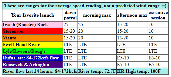
Looking st Saturday, we’ll have easterlies. Iwash/Rooster Rock starts at 25mph, and Stevenson starts at 15-20mph. By mid-morning, we’ll have 25mph at Iwash and 20mph at Stevenson, Home Valley, and Viento. As usual for summer easterlies, the wind will start to drop by noon. The wind holds at 20mph at those usual east wind spots until 2pm or so, and then drops to 10-13mph. River flow over the last 24 hours was 84-172kcfs, river temp is 72.7F (poor salmon), and high temp forecast is 100F for Hood River.
RIVER FLOW FOR SITES BETWEEN AVERY (EAST OF THE DALLES) AND RUFUS: CLICK HERE FOR JOHN DAY DAM FLOW.
RIVER FLOW FOR SITES BETWEEN STEVENSON AND DOUG’S BEACH (WEST OF THE DALLES): CLICK HERE FOR THE DALLES DAM FLOW

sunday’s gorge wind forecast
Sunday starts dead calm everywhere. Looks like a great morning for a bike ride or for spraying fungicide (rhyme intended). Westerlies pick up to 10-13 mph from Stevenson to Doug’s late afternoon. High temp: 100F, unless mid and high clouds are thicker than expected.
extended Gorge wind forecast
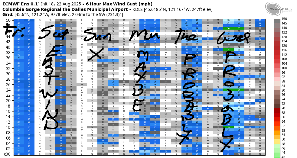
The GFS and the Euro ensembles really start to diverge on Monday. The GFS thinks we’ll see a slow build to 16-19mph from Stevenson to Mosier on Monday afternoon. Euro ensembles: they think there’s maybe a 15% chance of 15mph or more. The euro has a slightly better prognosis for the Corridor on Tuesday, but still barely 17-20mph if we’re lucky.
GFS deterministic for Tuesday: I’m guessing it’s an outlier, because it’s calling for 27-30mph on Tuesday, Wednesday, and Thursday! Looking at the Euro ensembles, it doesn’t return strong wind to the Gorge until Thursday or Friday. After that: I’m going on a retreat for six days which should pretty much guarantee wind every day! Actually, models are hinting at more active weather and a different type of lesser-wind scenario, the kind that’s dominated by an offshore low. Stay tuned. I’ll see y’all tomorrow evening here, and I’ll see you tomorrow daytime at a swimming hole!
Was that helpful? I knew it was! Guess what? All of this crucial work – from your personal wind and snow reports to the invaluable TATAS updates – is made possible by my relentless efforts. Maintaining this labor of love isn’t easy. Each daily forecast takes hours. Website hosting, weather model access, and back-end admin work takes time and money. That’s where you come in.
YOUR CONTRIBUTION MAKES A DIFFERENCE
- SUPPORT ACCURATE, HYPER-LOCAL WEATHER FORECASTING
- ENABLE ACCESS FOR ALL, EVEN THOSE WITH LESS MEANS
- SUPPORT A COOL HUMAN WHO WORKS HARD SO YOU CAN PLAY
Take a moment to click one of the buttons below. Donate $19.99 or more (how much does this forecast enhance your life?) and get the email in your inbox. Whether it’s a renewing subscription (auto-renew) or a one-time donation, every contribution makes a real difference. Help me keep this labor of love alive, so we can all continue playing, commuting, and living in the Gorge with peace of mind and the best weather forecasts possible. Thank you!


Hood River, Oregon 97031


JONES BEACH, SAUVIE ISLAND, & COAST FORECAST
Wind northerly unless otherwise indicated. For coast, it’s North/Central/South with the “central” at approximately Florence. Swell forecast from NWS for central coast. Jones: westerly unless otherwise stated. Sauvie Island: northerly unless otherwise stated. Coast Saturday: 15-20/LTNW/N5-10, N swell 4′ @ 5 seconds. Sunday: 15-20/NW10/N15-20, NW 4′ @ 8. Monday: 15-20/15-20/25-30, NW 5′ @ 8. Jones Saturday: 7-10. Sunday: 19-22. Monday: 22-25. Sauvie Island Saturday: 8-11. Sunday: 12-15. Monday: 14-17.
BARE BONES HOOD RIVER WEATHER FORECAST
Saturday will be mostly clear with a few high clouds. Temps start in the mid 60s and rise to the upper 90s. Light easterlies. No rainbows. Sunday will be mostly clear with some mid/high clouds possible in the afternoon. Temps start in the upper 60s and rise to 100 or so. Muggy. Calm wind early. Light westerlies later. No rainbows. Monday will be mostly clear. Temps start in the low 70s and rise to the upper 90s. Light westerlies early. Moderate later. No rainbows.
TEMIRA’S AWESOME TRAVEL ADVISORY SERVICE – SATURDAY 8/23
HYPERLOCAL WEATHER FORECAST FOR THE COLUMBIA GORGE
THE DALLES, HOOD RIVER, WHITE SALMON, TROUT LAKE, STEVENSON, CASCADE LOCKS, PARKDALE, ODELL, HUSUM, BZ, MILL A, WILLARD, GOLDENDALE, RUFUS, ARLINGTON, boardman
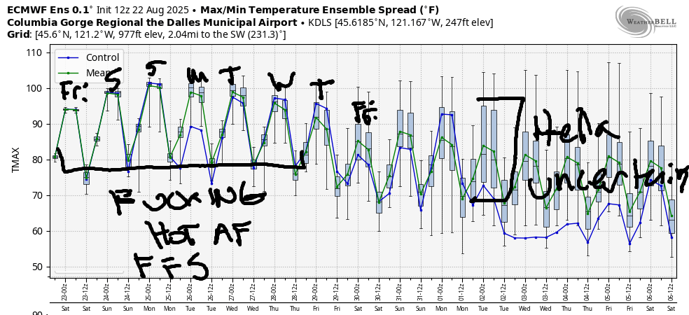
Good evening, neighbors! It’s late on Friday, and I’m writing this forecast for Saturday now so I can get out early and exercise before the heat (and before my 9am-3pm Buddhist Psychology Zoom training). The weather looks FUCKING HOT for the next several days. Models suggest Hood River will drop below 95 on Thursday, but it’ll be longer than that for The Dalles. Major uncertainty is present starting next Thursday, and it only increases deeper into the future. As a matter of fact, the high temp spread for Labor Day (#WorkersRights, #UnionStrong) is 73-94 degrees. DO NOT TRUST YOUR PHONE FORECAST FOR LABOR DAY!
Saturday’s Gorge weather forecast
Looking at Saturday, we’ll have the coolest start we’ll see for a while: mid 60s. After Saturday, humidity and the potential for some high clouds lead to really warm, potentially record-setting morning warmth. It bears repeating that a very, very, very consistent sign of climate change in the PNW is warming morning temps (normal for Hood River is 50-52F this time of year and 53-55F in the hottest parts of the summer). Anyway, back to Saturday… temps rise to 100+ everywhere. The End. Oh wait, not the end. Wind will be easterly: 25mph near Iwash fading to 10mph late; 20mph near Stevenson fading to 10mph late. 5-10mph from Hood River eastward in the afternoon with more in the hills.
Sunday’s Gorge weather forecast
Overnight into Sunday, humidity increases and temps only fall into the upper 60s. Some areas will be hotter. Record high-low for Hood River on Sunday morning: 64F, almost certain to break. Afternoon highs rise to the low triple digits in Hood River and the desert and around 105F in The Dalles. Wind: calm the first half of the day. West 10mph in the afternoon between Stevenson and Murdoch.
Monday’s Gorge weather forecast
With moisture pushing in from the south, Monday morning will be hot, 70 degrees or more, and almost certainly record-setting. Thanks to some high clouds and light onshore flow, it might be slightly cooler on the west side; upper 90s. The Dalles: 105. Desert: 101. West wind starts at 10mph from Stevenson to Hood River and rises to 15-20mph from Stevenson to Mosier. Or maybe not. Models are all over the place on the wind.
Extended Gorge weather forecast
Generally speaking, Tuesday looks nearly as hot, muggy, and oppressive as Monday. Slightly more west wind will arrive. Ditto for Wednesday. That said, there’s some serious disagreement between the GFS deterministic and Euro ensemble for the weather from Tuesday onward. More than likely it will still be FUCKING HOT through Wednesday. Cooling of some sort is likely Thursday and Friday along with stronger west wind.
It’s worth mentioning that there’s some chance of thunderstorms Sunday through Thursday, but the indicators aren’t all that clear. It will be muggy. It will be unstable. But it’s unclear if there will be enough “oomph” to the setup to actually fire off storms. That’s both good and bad: we really could use some rain, but we really don’t need lightning and fires. Speaking of rain, about 40% of the Euro ensembles have a quarter inch or more in the week of Labor Day (#UnionStrong, #Solidarity). But given the likelihood of regression to the mean, I’d put money on the signal for rain fading from the models. I’ll be on retreat the first half of that week, and rain would be damned awesome while I’m meditating. But meditating is awesome in my book anytime, rain or no rain. Safe travels. -TATAS
HEY! DON’T STOP READING! Is this community-focused forecast helpful to you? It sure is! It takes me a couple hours a day to write. Please join your friends and neighbors in contributing to keep it going. Venmo: @thegorgeismygym PayPal: twomirrors@gmail.com USPS: Temira / PO Box 841 / Hood River, Oregon 97031 You can test out the forecast subscription for a few days for free by signing up below. Easy! Do it!
MT HOOD SNOW FORECAST

CURRENTLY ON VACATION. WILL RETURN SOMETIME BEFORE THE START OF SKI SEASON AT MEADOWS, TIMBERLINE AND SKIBOWL. SAME GOES FOR THE NORDIC SKIING SEASON AT MEADOWS AND TEACUP!
