

GORGE WIND FORECAST
If you’re still seeing yesterday’s and it’s after 9am, try opening this in an incognito window
today’s gorge wind forecast
Hi friends! Hot (and muggy) weather is forecast this weekend, but thanks to hotter weather in the desert, the westerlies keep on rolling. A bit of a cooldown on Monday results in stronger wind, yay. Ensembles have Monday as the windiest day of the next four to five, but lots of uncertainty is present in the Gorge wind forecast models from Tuesday on. Somewhere down the road, probably Thursday or Friday, we’ll have a more significant cooldown and a round of stronger westerlies. With the general picture out of the way, let’s start with the details for this weekend.
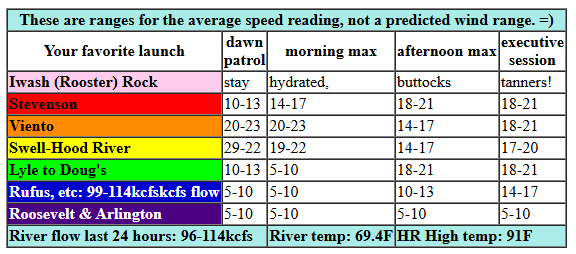
It’s Saturday, and the early pressures were 30.10/30.01/30.00 for gradients of 0.09 (PDX-DLS) and 0.01 (DLS-PSC). At dawn, Viento was 17-20mph, and Swell-Hood River was 10-15mph. Marine clouds under-performed yesterday’s model run for today: there are no clouds in the metro area and no sign of them pushing in. Models give us a shot at a couple hours of 19-22 from Viento to Swell this morning before the wind drops. We then have 14-17 from Stevenson to Mosier until late afternoon when the wind rises to 17-20 from Stevenson to Mosier with 14-17 from Lyle to Doug’s. There’s a slight chance of low 20s late in the day between Stevenson and Swell thanks to ten degrees of temp difference across the Cascades, but I’d call it low probability. River flow over the last 24 hours was 96-114kcfs, river temp is 69.4F, and high temp forecast is 91F for Hood River. Whatever strength wind we get, it’ll be a great day to get in the river with the heat and humidity we’re expecting!
RIVER FLOW FOR SITES BETWEEN AVERY (EAST OF THE DALLES) AND RUFUS: CLICK HERE FOR JOHN DAY DAM FLOW.
RIVER FLOW FOR SITES BETWEEN STEVENSON AND DOUG’S BEACH (WEST OF THE DALLES): CLICK HERE FOR THE DALLES DAM FLOW

tomorrow’s gorge wind forecast
Sunday starts with 10mph or so from Stevenson to Swell. Calm wind arrives by mid-morning and sticks around for a few hours. As temp gradients build late afternoon, westerlies pick up. You’ll be very glad for this, as high temps are forecast to be in the upper 90s! Westerlies rise to 18-21 from Stevenson to Doug’s mid to late afternoon and hold into the evening, when Rufus will rise to 14-17mph. High temp: 97F for Hood River and 102F in Rufus.
extended Gorge wind forecast
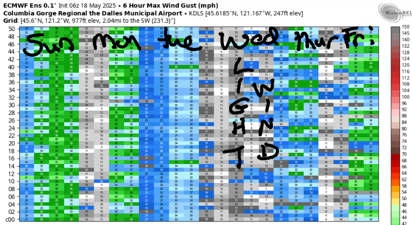
A passing system on Monday drags low clouds into the west side and allows a massive cross-Cascade temp gradient to flourish: 16 degrees difference between the metro area and the desert. Quite a bit of range exists in the wind forecast, but we should see 22-25mph or better from Stevenson to Doug’s all day and Rufus late afternoon into the evening. High temp: 87F for Hood River and 95F for Rufus.
Uncertainty explodes on Tuesday with models all over the place on wind potential. Euro ensembles have a lighter day, perhaps 19-22mph. The GFS deterministic is currently all in with 30-33mph. I’m leaning on the Euro for now, as the GFS appears to be an outlier. Similarly high uncertainty is present for Wednesday. About 80% of the ensemble members indicate stronger wind Thursday followed by decent westerlies through next weekend. Fingers crossed! And especially fingers crossed for today – it’s going to be hot and muggy, and it’ll be great to get in the river. I’ll see you out there!
Was that helpful? I knew it was! Guess what? All of this crucial work – from your personal wind and snow reports to the invaluable TATAS updates – is made possible by my relentless efforts. Maintaining this labor of love isn’t easy. Each daily forecast takes hours. Website hosting, weather model access, and back-end admin work takes time and money. That’s where you come in.
YOUR CONTRIBUTION MAKES A DIFFERENCE
- SUPPORT ACCURATE, HYPER-LOCAL WEATHER FORECASTING
- ENABLE ACCESS FOR ALL, EVEN THOSE WITH LESS MEANS
- SUPPORT A COOL HUMAN WHO WORKS HARD SO YOU CAN PLAY
Take a moment to click one of the buttons below. Donate $19.99 or more (how much does this forecast enhance your life?) and get the email in your inbox. Whether it’s a renewing subscription (auto-renew) or a one-time donation, every contribution makes a real difference. Help me keep this labor of love alive, so we can all continue playing, commuting, and living in the Gorge with peace of mind and the best weather forecasts possible. Thank you!


Hood River, Oregon 97031


JONES BEACH, SAUVIE ISLAND, & COAST FORECAST
Wind northerly unless otherwise indicated. For coast, it’s North/Central/South with the “central” at approximately Florence. Swell forecast from NWS for central coast. Jones: westerly unless otherwise stated. Sauvie Island: northerly unless otherwise stated. Coast Saturday: 25/25/35, NW swell 7′ at 11 seconds. Sunday: 25/25-30/30-35, NW 7′ @ 10. Monday: 20/25-30/35+, NW 7′ @ 8. Jones Saturday: 20-23. Sunday: 19-22. Monday: 22-25. Sauvie Island Saturday: 13-16. Sunday: 19-22. Monday: 13-16.
BARE BONES HOOD RIVER WEATHER FORECAST
Clear sky all day. Temps start near 70 and rise to 90. Moderate westerlies. No rainbows. Sunday will be sunny. Temps start in the mid 60s and rise to the upper 90s. Calm wind early. Moderate westerlies later. No rainbows. Monday will be clear and sunny with a few low clouds possible early. Temps start in the upper 60s and rise to the upper 80s. Moderately strong to strong westerlies. No rainbows.
TEMIRA’S AWESOME TRAVEL ADVISORY SERVICE – SATURDAY 7/12
HYPERLOCAL WEATHER FORECAST FOR THE COLUMBIA GORGE
THE DALLES, HOOD RIVER, WHITE SALMON, TROUT LAKE, STEVENSON, CASCADE LOCKS, PARKDALE, ODELL, HUSUM, BZ, MILL A, WILLARD, GOLDENDALE, RUFUS, ARLINGTON, boardman

Good morning, neighbors! NWS has an Extreme Heat Watch in place for the middle of next week, but I’ve decided we should have one this weekend to prepare for that one. Since we can’t steal their product, we’ll have an Expressive Excessive Heat Watch: grab some water, find a cool and shady spot next to a swimming hole, and express yourself through art, interpretive naked dance, or writing haiku for next week’s “Cold Mornings, Bad Haiku” event in Glenwood.
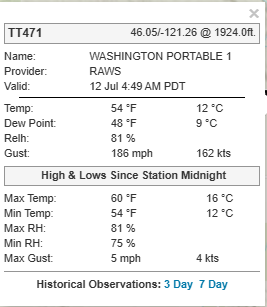
Glenwood this morning
PS, I made that event up, but it would be fun! Glenwood was 50 degrees this morning, and according to the map I looked at, the wind was gusting to 186mph. With wind like that, Glenwood has probably been blown to a new location, but I didn’t check the wind direction, so I’m not sure where to look. Glenwood residents, I hope you are okay!
everyone else this morning
For the rest of us today: after a hot start – 70 at HoodRiverWeather.info, 75 at Celilo Village, 60 in Parkdale – we have a hot finish. Temps max out at 90 on the west side and a couple degrees shy of 100 from The Dalles eastward. West wind will be 15-20mph pretty much all day between Stevenson and The Dalles with 15-20mph in the evening as far east as Rufus. For those of you who like muggy weather (my friend Carly and nobody else), you’ll get it this afternoon when moisture pushes in from the west and causes the dewpoint to rise to 58 degrees as far east as Pendleton. In response, farmers break out the Trionic and Luna Sensation and copper sprays for the ongoing battle with Powdery Mildew. People without a pesticide applicator license can break out the diluted milk.
SUNDAY GORGE WEATHER FORECAST
Clear sky sticks around overnight. Thanks to the high dewpoint, we’ll start out warm again on Sunday: 65+ in the lowlands. Given the hot start, the humidity, and extreme heat forecast, we’ll repeat the TATAS Expressive Excessive Heat Watch. Except it’s imminent, so it’s now a Warning. Temps rise to 97 (west), 102 (The Dalles), and 104 (watermelon-growing zones near Hermiston). Wind will be calm to start. In the afternoon, it picks up to 15-25mph from Stevenson to Avery with 15-20mph from Celilo Village to Rufus. If those temps aren’t hot enough for you, add in a dewpoint of 57 degrees to make weather that resembles a sticky bun, which is what YOUR buns will resemble after being in such hot, muggy weather.
MONDAY’S GORGE WEATHER FORECAST
Relief-ish comes in the form of a shortwave on Monday. High temps fall 10 degrees from Sunday’s unreasonably warm weather. As the system moves through, the dewpoint falls too, and the air goes from swampy to silky. I have no idea what silky air is, but I needed alliteration. Highs will be upper 80s (west), low 90s (The Dalles), and 100 degrees (where the watermelons are growing). West wind will be 20-25mph from Stevenson to Rowena in the morning and 20-30mph from Stevenson to Rufus in the afternoon. Tuesday currently looks about as hot as Monday but not as windy. Or, if you believe the GFS deterministic, it’ll be a hell of a lot windier. And this is why we can’t have nice things: because forecasting weather is a tricky business. Oh, wait. All the nicest things in life actually come from the processes of our mind. We just have to cultivate good mental states, and they’ll be there regardless of the weather or conditions in our lives. Although having our basic needs met helps a lot, which is part of the reason why SNAP (food assistance), universal healthcare, and affordable housing are important. How heartbreaking it is that this country’s citizens and leaders can’t open their hearts and help every person have food, healthcare, and housing.
EXTENDED GORGE WEATHER FORECAST
On to the extended forecast: we have that NWS Extreme Heat Watch posted Tuesday into Wednesday for hot weather and warm overnight temps. TATAS recommends you book a hotel room or campground spot in Glenwood, Husum, Trout Lake, Parkdale, or other cool spot. Don’t get too high in elevation, because you’ll be above the overnight inversion and in warmer temps. And don’t get too high, because then you won’t be able to properly appreciate the cool air. TBH, the range of temps for The Dalles Tuesday is 88-92; Wednesday 91-95; Thursday: 81-95, which means it won’t be blazing hot. Just hot like it already is. Unless there’s a dramatic change, this weekend will be hotter and muggier than next week’s heat, which will be just warm enough to keep the “sticky buns” theme going. Safe travels. -TATAS
HEY! DON’T STOP READING! Is this community-focused forecast helpful to you? It sure is! It takes me a couple hours a day to write. Please join your friends and neighbors in contributing to keep it going. Venmo: @thegorgeismygym PayPal: twomirrors@gmail.com USPS: Temira / PO Box 841 / Hood River, Oregon 97031 You can test out the forecast subscription for a few days for free by signing up below. Easy! Do it!
