

GORGE WIND FORECAST
today’s gorge wind forecast
Hi friends! Apologies for the late Gorge wind forecast this morning. I didn’t manage my sleep well last night. First off today, I’d like to wish a very happy Victoria Day weekend to all our friends from Canada. Know that we’ve got your back and welcome you here if you want to come visit. Cheezies or no Cheezies, you’re welcome. We have a windy three-day weekend on tap for anyone in the Gorge, Canadian or otherwise!
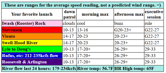
Saturday kicked off with partly to mostly cloudy sky at least as far east as The Dalles. Cool air will be reinforcing itself from the NW today, and a weak system will approach Vancouver Island. Offshore, high pressure is about 1027mb, enough to give a kick to the Gorge wind. Westerlies pick up slowly today. By late morning, we”ll have gusty 19-23 from Stevenson to Hood River with 17-20 from Mosier to Rufus. From then on, it’s all up with max speeds kicking in starting around 2pm: gusty 20-26 from Stevenson to Hood River, 26-29 at Mosier, 29-33 from Mosier to Arlington, and 26-29 at Threemile. Given 850mb wind that builds to NW 35+ this evening, 33+ is possible for the Avery-Rufus zone if we get lucky and get that support early enough. Patience will pay off today if you’re seeking strong wind. River flow over the last 24 hours was 212-235kcfs at Rufus and 179-234kcfs out of The Dalles Dam. Water temp is 56.7F, and high temp forecast is 65F for Hood River and 67F with more sunshine at Arlington. If you’re heading east, don’t forget to pick up Indian food at Amayah’s!

tomorrow’s gorge wind forecast
Offshore high pressure lessens on Sunday, but upper-level support and synoptic-scale support from a low in the Rockies keeps strong wind going. Dawn Patrol looks like 17-20 with clouds from Stevenson to Hood River, 26-29 from Mosier to Arlington, and 23-26 east of Arlington to Boardman. Give it a few hours to warm up a bit, and we’ll have 28-32 from Lyle to Arlington with gusty 21-24 from Stevenson to Mosier. Threemile climbs to the low 30s in the afternoon, and areas west of Mosier drop to 17-20. Models indicate falling wind after 5pm, so aim for the late morning to mid afternoon period for best/strongest results. High temp: 60F for Hood River and 61F for Arlington with partly cloudy to mostly clear sky by afternoon.
extended Gorge wind forecast
A system swings through on Monday and drives drizzle as far east as The Dalles. Early wind will be 10mph or less. Afternoon brings cloudy, gusty 11-14 west of The Dalles thanks to showers and 26-29 from Avery to Boardman thanks to strong high pressure building off the coast late in the day. High temp: 63F for Hod River and 66F for Arlington.
Uncertainty multiples on Tuesday. As of now, models suggest low to mid 20s. Westerlies appear likely to continue into next week, but there’s just too much range to really take a stab at the wind speeds. Have a great weekend, everyone. I’ll see you on the Nch’i Wana!
Was that helpful? I knew it was! Guess what? All of this crucial work – from your personal wind and snow reports to the invaluable TATAS updates – is made possible by my relentless efforts. Maintaining this labor of love isn’t easy. Each daily forecast takes hours. Website hosting, weather model access, and back-end admin work takes time and money. That’s where you come in.
YOUR CONTRIBUTION MAKES A DIFFERENCE
- SUPPORT ACCURATE, HYPER-LOCAL WEATHER FORECASTING
- ENABLE ACCESS FOR ALL, EVEN THOSE WITH LESS MEANS
- SUPPORT A COOL HUMAN WHO WORKS HARD SO YOU CAN PLAY
Take a moment to click one of the buttons below. Donate $19.99 or more (how much does this forecast enhance your life?) and get the email in your inbox. Whether it’s a renewing subscription (auto-renew) or a one-time donation, every contribution makes a real difference. Help me keep this labor of love alive, so we can all continue playing, commuting, and living in the Gorge with peace of mind and the best weather forecasts possible. Thank you!


Hood River, Oregon 97031


JONES BEACH, SAUVIE ISLAND, & COAST FORECAST
Wind northerly unless otherwise indicated. For coast, it’s North/Central/South with the “central” at approximately Florence. Swell forecast from NWS for central coast. Jones: westerly unless otherwise stated. Sauvie Island: northerly unless otherwise stated. Saturday: NW15-20/NNW15-20/N15, W swell 6′ at 11 seconds. Sunday: LTW/LTW/N15, W 5′ @ 11. Monday: W10/W10/LTV, W 5′ @ 11. Jones Saturday: 15-18. Sunday: 14-17. Monday: LTW. Sauvie Island Saturday: WNW 15-18. Sunday: W 15-18. Monday: LTV.
BARE BONES HOOD RIVER WEATHER FORECAST
Mostly cloudy this morning with sprinkles. Partly cloudy later. Temps start in the mid 50s and rise to the mid 60s. Light westerlies early. Moderately strong later. 93% chance of rainbows. Sunday will be cloudy then partly cloudy. Temps start in the low 40s and rise to the low 60s. Moderate westerlies. 1% chance of rainbows. Monday will be partly cloudy then cloudy then partly cloudy with sprinkles/drizzle on and off all day. Temps start in the low 40s and rise to the low 60s. Light westerlies early. Moderate later. 99.4% chance of rainbows.
TEMIRA’S AWESOME TRAVEL ADVISORY SERVICE – SATURDAY 5/17
HYPERLOCAL WEATHER FORECAST FOR THE COLUMBIA GORGE
THE DALLES, HOOD RIVER, WHITE SALMON, TROUT LAKE, STEVENSON, CASCADE LOCKS, PARKDALE, ODELL, HUSUM, BZ, MILL A, WILLARD, GOLDENDALE, RUFUS, ARLINGTON, boardman

Good morning, neighbors! I went to bed late (for me) last night and woke up late (for me) today, so I’m running behind. I’m also running behind because I’ve had WAY TOO MUCH CAFFEINE and keep impulsively texting lots of friends. Gonna try and keep this quick. Next several days: cool, partly cloudy, windy, and potentially a little showery.
glenwood’s start and today’s weather
Today’s fun facts: Glenwood started the day at 49 degrees, which is really quite warm for that location (which behaves more like Massachusetts than Washington), and Hood River picked up 0.16” of rain, which is enough to turn the trails from dusty to “brown pow”.
Drizzle or sprinkles are possible west of Hood River and in South Wasco county until mid-morning. After that, we all turn partly cloudy (west side) or mostly clear (east side). Speaking of clear, it’s already past 8:30, and I haven’t thanked the sun for coming up yet. Just took care of that. Now, back to the weather… We’ll see temps rise to the mid 60s near Hood River and a few degrees higher out in the desert. Don’t be fooled by the light wind this morning. By afternoon, we’ll have 25mph west of Mosier and 30-35mph from Mosier eastward to the Arlington Triangle (full bush in a bikini home location) and beyond. There is a bit of an aurora possibility tonight, so keep your eyes on the northern horizon.
tomorrow’s gorge weather forecast (sunday)
Oh gosh, I’m so scattered this morning and keep texting people. Too much joy, too much chocolate, too much caffeine. On to tomorrow’s weather: Cloudy in the west, sunny in the east, and sprinkly to Cascade Locks to start. Partly cloudy sky spreads like frosting (chocolate, of course) all across the Gorge in the afternoon. Westerlies will be 15-20mph west of Mosier to start with 25-30mph from Mosier to Arlington early in the day. If wind could be colored like clouds, it’d be a stunningly colorful morning. In the afternoon, the wind rises to 20-25mph west of Mosier with 25-35mph to the east. High temps hover right around 60 degrees all through the Gorge after a low 40s start. With that much wind early in the day, frost is unlikely, even in Glenwood, despite 850mb (5000′) temps around -2C.
Monday’s gorge weather forecast
Lesser wind on Monday morning gives you about five minutes of relief. You should also get a little drizzle if you’re west of The Dalles, and that drizzle might just continue, on-and-off, with rainbows, for much of the day. By afternoon, westerlies pick up to 10-15mph west of Avery and rise to 25-30mph from Avery to Boardman. High temp: low to mid 60s.
extended gorge weather forecast
Cool, good-germination weather continues all the way through next Friday. Models then bounce around all over the place between troughing and ridging, or cool and warm, with basically zero sign of any 90+ degrees weather. My favorite day of the extended forecast remains Monday the 26th of May, when models offer up a range of 65F to 89F for high temps. Uncertainty is the BEST. It gives you all sorts of opportunities to see how you make yourself anxious and worried and generally contribute to your own suffering, which does actually have the possibility of ending if you work at it. Safe travels. -TATAS
HEY! DON’T STOP READING! Is this community-focused forecast helpful to you? It sure is! It takes me a couple hours a day to write. Please join your friends and neighbors in contributing to keep it going. Venmo: @thegorgeismygym PayPal: twomirrors@gmail.com USPS: Temira / PO Box 841 / Hood River, Oregon 97031 You can test out the forecast subscription for a few days for free by signing up below. Easy! Do it!
