

GORGE WIND FORECAST
If you’re still seeing yesterday’s and it’s after 9am, try opening this in an incognito window
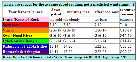
today’s gorge wind forecast
Hi friends! Active, tricky-wind weather continues for a couple more days. Starting Monday, we fall into an east wind pattern thanks to an offshore low pressure system. Looking deep into next week’s Gorge wind forecast, another possible pattern change shifts us into another possible round of decent westerlies. Ensembles and the GFS are already in some sort of agreement on west wind, so there’s hope despite the overall uncertainty in the forecast.
Let’s look at this morning. It’s Saturday, and I’m running late because I led a meditation group this morning. But hey, that’s my fav thing, so I’m happy for me! Today’s wind is brought to you courtesy of a system moving through. Most locations were under 10mph to start the day, but Viento-Hatch was reading 16-19mph. Models give us gusty, intermittently drizzly 15-20mph from Viento to the Hatch this morning. They suggest the wind will rise to gusty 22-25mph from Avery to Arlington this afternoon and hold. More intense, more widespread rain arrives around 5pm, so be ready for the west side to really drop off. River flow over the last 24 hours was 72-125kcfs, river temp is 66.0F, and high temp forecast is 59F for Hood River and 63F out east.
RIVER FLOW FOR SITES BETWEEN AVERY (EAST OF THE DALLES) AND RUFUS: CLICK HERE FOR JOHN DAY DAM FLOW.
RIVER FLOW FOR SITES BETWEEN STEVENSON AND DOUG’S BEACH (WEST OF THE DALLES): CLICK HERE FOR THE DALLES DAM FLOW

tomorrow’s gorge wind forecast
Another active weather day is in the cards on Sunday. Get it early before an incoming system shuts things down. For the morning, we’ll have gusty 15-28mph from Stevenson to The Dalles with gusty 22-25mph from Avery to Threemile. This, by the way, is leftovers from a stronger round of wind overnight Saturday into Sunday morning. Wrong timing for us since it’ll be dark. Anyway, after 2pm, heavier rain arrives. The west side drops below 10mph. Out east: gusty 14-17mph. High temp: cold! 55F for Hood River and 59F out in the desert.
extended Gorge wind forecast
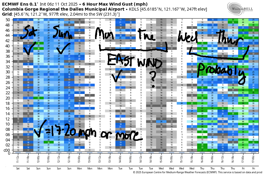
Monday sees a low settle offshore. Easterlies result. These easterlies won’t be confined to the river, and thus they’ll be lighter than gradients and models suggest. Call it 20-25mph at Iwash, 20mph at Stevenson, 15-20mph at Viento, and 10-20mph from Hood River eastward, especially away from the river and up in the hills, where the easterlies will be strong. High temp: 52F for Hood River. Some sort of easterlies, perhaps 20-25mph at Stevenson, are forecast Tuesday. Wednesday: potentially west wind. Thursday and Friday: potentially strong west wind. Fingers crossed. See you on the Nch’i Wana!
Was that helpful? I knew it was! Guess what? All of this crucial work – from your personal wind and snow reports to the invaluable TATAS updates – is made possible by my relentless efforts. Maintaining this labor of love isn’t easy. Each daily forecast takes hours. Website hosting, weather model access, and back-end admin work takes time and money. That’s where you come in.
YOUR CONTRIBUTION MAKES A DIFFERENCE
- SUPPORT ACCURATE, HYPER-LOCAL WEATHER FORECASTING
- ENABLE ACCESS FOR ALL, EVEN THOSE WITH LESS MEANS
- SUPPORT A COOL HUMAN WHO WORKS HARD SO YOU CAN PLAY
Take a moment to click one of the buttons below. Donate $19.99 or more (how much does this forecast enhance your life?) and get the email in your inbox. Whether it’s a renewing subscription (auto-renew) or a one-time donation, every contribution makes a real difference. Help me keep this labor of love alive, so we can all continue playing, commuting, and living in the Gorge with peace of mind and the best weather forecasts possible. Thank you!


Hood River, Oregon 97031


JONES BEACH, SAUVIE ISLAND, & COAST FORECAST
ON WINTER VACATION. WILL APPEAR IF NEEDED.
BARE BONES HOOD RIVER WEATHER FORECAST
Clouds this morning with intermittent light drizzle, most likely midday. Temps start in the low 50s and rise to the upper 50s. Light westerlies 44% chance of rainbows. Sunday will be drizzly then mostly cloudy then rainy again in the afternoon. Temps start in the mid 40s and rise to the mid 50s. Moderate westerlies early. Light later. 99% chance of rainbows. Monday will be cloudy with morning drizzle. Temps start in the low 40s and rise to the low 50s. Moderate easterlies. 16% chance of rainbows.
TEMIRA’S AWESOME TRAVEL ADVISORY SERVICE
HYPERLOCAL WEATHER FORECAST FOR THE COLUMBIA GORGE
THE DALLES, HOOD RIVER, WHITE SALMON, TROUT LAKE, STEVENSON, CASCADE LOCKS, PARKDALE, ODELL, HUSUM, BZ, MILL A, WILLARD, GOLDENDALE, RUFUS, ARLINGTON, boardman
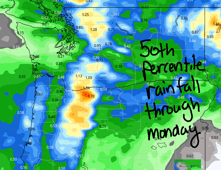
Good morning, neighbors! Looks like fall is here. Autumn. The beautiful creature with the changing leaves and changing weather and … yes… even some rain! Rain totals through Monday morning (after which we’ll have a few dry days) look significant all the way out into the desert. Bye, fire season. Hello explosion of wild mushrooms!
Glenwood this morning
Looking at Saturday morning, we have a late TATAS start thanks to a meditation group and meditation mentoring online. That group is based in BC, where it was still dark at 7am. Closer to home, it was light in Glenwood, but it was only 44 degrees. Everyone there is making clear plastic hooded onesies for the Emergency World Naked Bike Ride (clothing optional) in Portland tomorrow in protest of military being deployed on the streets to “protect” us from a dozen people dancing in inflatable animal costumes and a half dozen people “ICE fishing” with donuts hanging from fishing poles. SAD!
Today’s Gorge weather forecast
Rest of today: darn chilly (average high for the date is 66F in Hood River) and cloudy and intermittently drizzly. During the day, that intermittent drizzle extends to The Dalles. In the evening, it extends into Greater Idaho and almost to actual Idaho, which will remain within its borders once it realizes that most of the $$$ comes from Cascadia. Wind today will be 15mph or less west of The Dalles and will slowly build to 20-25mph east of The Dalles. A period of stronger wind is possible overnight, so don’t leave your rubbish bins out! Temps max out in the upper 50s (west) and low to mid 60s from Dallesport eastward.
Sunday’s Gorge weather forecast
A low butts up against the coast on Sunday and shakes its buttocks. This results in moderate rain most of the day west of Mosier with drizzle east of The Dalles and in south Wasco County. In the afternoon and evening, rain intensity increases as does the coverage: all of us, all the way to Idaho, will be threatened by drizzle (and also threatened with the lack of democracy and ALSO WTF WITH A QATARI MILITARY BASE IN IDAHO???). Sunday’s wind will be 15mph west of The Dalles in the morning and 25mph east of The Dalles as far east as perhaps Plymouth. Afternoon: less than 10mph west of The Dalles and 15-20mph east of The Dalles. Sunday’s high temps will be 10 degrees below normal resulting in a snow level of around 4000′. Combine this with west wind at 30mph aloft for significant snowfall especially above 5000′: up to a foot is possible. Bennett Pass: likely snowy. Highs down along the river: 55F to the west and 58-59F to the east.
Monday’s Gorge weather forecast
That coastal low sticks around Monday and results in widespread moderate east wind, continued cold temps, and continued cloud coverage. Morning drizzle gives way to plain-old-cloudy sky in the afternoon. Temps: VERY CHILLY. 52F in the west, 55F in The Dalles, and 60F in the desert. East wind will be 30mph near Iwash (cock) Rock, 20-25mph near Stevenson, and 10-20mph from Hood River eastward all day long. Thanks to the cloud coverage, frost is unlikely in the Gorge despite the freezing level being around 4000′.
Extended Gorge weather forecast
On Tuesday, clear sky, low humidity, and lighter east wind put many areas at risk of frost. Glenwood: definitely! Centerville, High Prairie, Snowden, Trout Lake, Goldendale, Parkdale, Steele Road area of The Dalles: likely. Odell and Mosier: maybe. Hood River and White Salmon: probably not. Highs Tuesday will be 60-64F under sunny sky. Similar conditions are forecast Wednesday. After that? Uncertainty increases, so I’ll shush.
Valuable Advice for Gardeners Inhabiting Neighboring Areas: get those cover crops in right now, and they’ll have a good chance of germinating in next week’s dry, sunny, relatively warm weather. I’M SO EXCITED FOR COVER CROPS! It’s also time to source your garlic. In the lowlands, planting week is the last week of October. K. That’s enough for now. Happy gardening. Safe travels. -TATAS
HEY! DON’T STOP READING! Is this community-focused forecast helpful to you? It sure is! It takes me a couple hours a day to write. Please join your friends and neighbors in contributing to keep it going. Venmo: @thegorgeismygym PayPal: twomirrors@gmail.com USPS: Temira / PO Box 841 / Hood River, Oregon 97031 You can test out the forecast subscription for a few days for free by signing up below. Easy! Do it!
MT HOOD SNOW FORECAST

CURRENTLY ON VACATION. WILL RETURN SOMETIME BEFORE THE START OF SKI SEASON AT MEADOWS, TIMBERLINE AND SKIBOWL. SAME GOES FOR THE NORDIC SKIING SEASON AT MEADOWS AND TEACUP!
