

GORGE WIND FORECAST
If you’re still seeing yesterday’s and it’s after 9am, try opening this in an incognito window
today’s gorge wind forecast
Hi friends! Today looks like a great day to get yourself on the river! Westerlies continue tomorrow, but they’ll be impacted by a weather system moving through along with a little bit of drizzle. Glorious fall weather on Monday basically shuts the wind down, and a different kind of glorious fall weather gives us enough east wind on Tuesday to get you on the river. Models still hint at some sort of west wind on Wednesday and Thursday, but there’s way to much uncertainty to make plans yet.
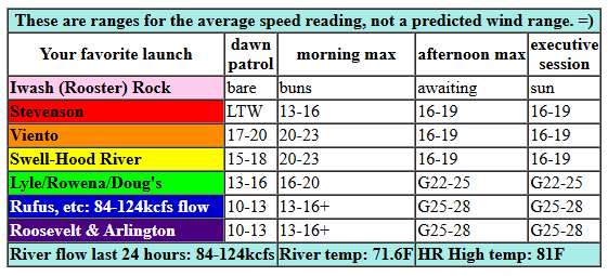
Looking at this morning (it’s Saturday!), we have pressure of 30.00/29.91/29.89 for gradients of 0.09/0.02. Metro area: clear sky. Offshore: approaching frontal system. For the morning, we’ll see a quick build to 20-23mph between Viento and the Hatch with 17-20mph at Stevenson and Hood River and 12-15mph at Mosier. Afternoon wind drops to 16-19mph from Stevenson to Hood River and rises to 24-27mph from Mosier to Arlington with maybe a couple mph more possible from Avery eastward. It’s worth noting that the approaching front is likely to make the wind quite up-and-down this afternoon. Remember that those eastern Gorge sensors read high compared to the Swell sensor; 24-27mph out east is more like 18-21mph at Swell. River flow over the last 24 hours was 84-124kcfs, river temp is 71.6F, and high temp forecast is 81F for Hood River and 86F out in the desert.
RIVER FLOW FOR SITES BETWEEN AVERY (EAST OF THE DALLES) AND RUFUS: CLICK HERE FOR JOHN DAY DAM FLOW.
RIVER FLOW FOR SITES BETWEEN STEVENSON AND DOUG’S BEACH (WEST OF THE DALLES): CLICK HERE FOR THE DALLES DAM FLOW

tomorrow’s gorge wind forecast
Sunday sees a cold front swing through the Gorge. Clouds fill in all the way east for the morning hours, and some rain falls until early afternoon. Despite this, the day starts breezy: 12-15mph from Stevenson to The Dalles and 18-22mph from Avery to Boardman. Afternoon: 15-18mph from Stevenson to Mosier (or perhaps to Doug’s), 21-24mph from Avery to Arlington, and 17-20mph east of Arlington out to the Tri-Cities. High temp: 67F in Hood river and 73F out east.
extended Gorge wind forecast
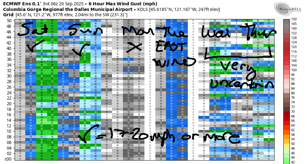
A ridge builds in on Monday. All the clouds burn off, temps warm across the land, and the wind goes calm, at least to start. Midday easterlies rise to 15mph near Stevenson with 10mph at Iwash (Rooster) Rock and Viento. The wind drops to 10mph in the afternoon. High temp: 75F. Easterlies look stronger on Tuesday, perhaps 25mph at Stevenson and Iwash. Beyond Tuesday, model uncertainty increases, and it’s really not responsible of me to make a prediction beyond that! Let’s give it a day or two to shake out! See you on the Nch’i Wana!
Was that helpful? I knew it was! Guess what? All of this crucial work – from your personal wind and snow reports to the invaluable TATAS updates – is made possible by my relentless efforts. Maintaining this labor of love isn’t easy. Each daily forecast takes hours. Website hosting, weather model access, and back-end admin work takes time and money. That’s where you come in.
YOUR CONTRIBUTION MAKES A DIFFERENCE
- SUPPORT ACCURATE, HYPER-LOCAL WEATHER FORECASTING
- ENABLE ACCESS FOR ALL, EVEN THOSE WITH LESS MEANS
- SUPPORT A COOL HUMAN WHO WORKS HARD SO YOU CAN PLAY
Take a moment to click one of the buttons below. Donate $19.99 or more (how much does this forecast enhance your life?) and get the email in your inbox. Whether it’s a renewing subscription (auto-renew) or a one-time donation, every contribution makes a real difference. Help me keep this labor of love alive, so we can all continue playing, commuting, and living in the Gorge with peace of mind and the best weather forecasts possible. Thank you!


Hood River, Oregon 97031


JONES BEACH, SAUVIE ISLAND, & COAST FORECAST
Wind northerly unless otherwise indicated. For coast, it’s North/Central/South with the “central” at approximately Florence. Swell forecast from NWS for central coast. Jones: westerly unless otherwise stated. Sauvie Island: northerly unless otherwise stated. Coast Saturday: W5-10/LTW/N15, NW swell 5′ at 12 seconds. Sunday: LTNW/N10/N20, W 7′ @ 11. Monday: 15/20/25-30, W 7′ @ 12. Jones Saturday: 13-16. Sunday: 7-10. Monday: LTW. Sauvie Island Saturday: LTN. Sunday: LTV. Monday: 5-8.
BARE BONES HOOD RIVER WEATHER FORECAST
Clear sky all day today. Temps start in the mid 60s and rise to the low 80s. Moderately strong westerlies. No rainbows. Sunday will be drizzly then partly cloudy. Temps start in the mid 50s and rise to the upper 60s. Moderate westerlies. 98% chance of rainbows. Monday will be partly cloudy then clear. Temps start in the upper 40s and rise to the mid 70s. Calm wind early. Light easterlies from midday on. No rainbows.
TEMIRA’S AWESOME TRAVEL ADVISORY SERVICE – SATURDAY
HYPERLOCAL WEATHER FORECAST FOR THE COLUMBIA GORGE
THE DALLES, HOOD RIVER, WHITE SALMON, TROUT LAKE, STEVENSON, CASCADE LOCKS, PARKDALE, ODELL, HUSUM, BZ, MILL A, WILLARD, GOLDENDALE, RUFUS, ARLINGTON, boardman
Good morning, neighbors! We’re just 24 hours out from a lot of clouds and a wee bit of a rain. Between now and then: yet another warm and muggy day. After our brief Sunday bout with fall, we’ll have a perfect fishing day on Monday (light wind east of Drano Lake, 75 degrees). That’s followed by warmer weather Tuesday and then uncertainty from Wednesday on into the extended forecast.
Glenwood this morning!
The most exciting thing in the extended forecast has to do with Glenwood on Monday morning. But first, Glenwood this morning is 41 degrees. Chilly! That’s cool enough to sit outside and sharpen the mind by engaging with the air like you would with a cold shower. Speaking of showering, I think I’ll take one today! Back to Glenwood on Monday morning… with clear sky, calm wind, and 850mb temps around 7-8C, Glenwood’s going to drop into the 30s. COLD!
Today’s Gorge weather forecast
For the rest of the Gorge today… another round of clear sky, sunshine, warmth, and relatively muggy weather. Temps surge to the low 80s (west), mid 80s (the Dalles) and 90 degrees (Hermiston watermelon-growing zone). West wind rises to 20-25mph this morning from Viento to the White Salmon bridge before dropping to 15-20mph this afternoon between Stevenson and Hood River. East of Hood River, the wind slowly builds to 25-30mph and eventually extends to Arlington.
Tonight: a waning crescent moon gives us spectacular star-gazing conditions. While I was looking that up, I asked The Google how many stars are in the sky. The most poignant related search: “Are there more stars than grains of sand?” For some reason the earnestness behind this search query really touched my heart and made me smile. Hopefully it does the same to you.
Sunday’s Gorge weather forecast
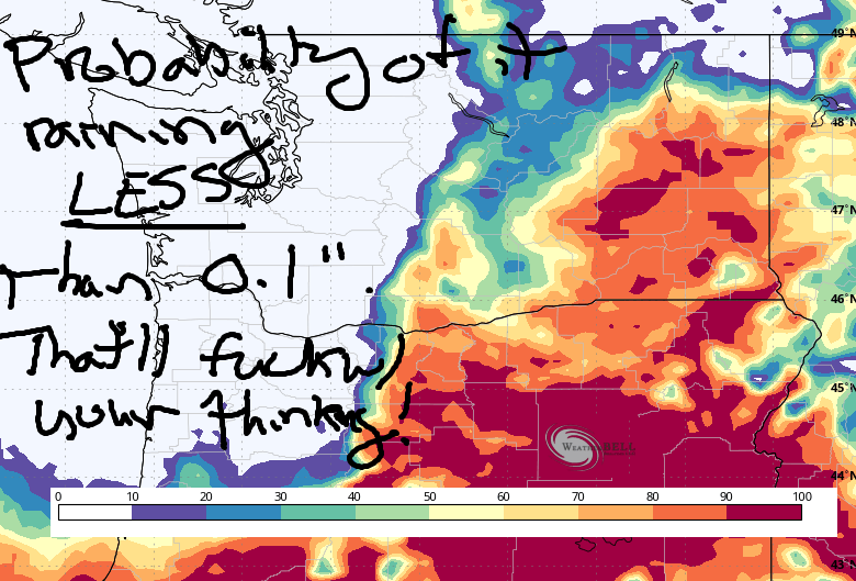
On Sunday, a cold front swings through the Gorge. You can see the probability of it raining LESS than 0.1” on the image. (Just messing with our heads by switching to this model product!) Rain falls west of Cascade locks starting around 5am and extends all the way to the Tri-Cities (and my friend Chris’ home) around 11am. Rain ends by 2pm for all of us, and we all finish the day with mostly clear sky. Along with the rain, we’ll have rainbows: 98% chance tomorrow for all locations. West wind will be 15mph west of The Dalles to start with 20-25mph east of The Dalles to Boardman. Afternoon: 15-20mph from Stevenson to Murdoch and 20-25mph from Avery to Boardman. Highs range from 67F in Hood River (chilly, yay!) to 74F from The Dalles eastward into the desert.
Extended Gorge weather forecast
Sunshine returns on Monday. With 850mb temps around 7-8C, light wind, and rather low dewpoints – mid 30s away from the Nch’i Wana and low to mid 40s along it – we’ll have our chilliest morning in a long, long time: 30-something in Glenwood and 40-something most other places. We could even see a little bit of a Nothing cloud! Afternoon temps rise to 75F (west and east) and 80F (The Dalles). Wind will be minimal: calm to start, E 15mph between Iwash (Rooster) Rock and Viento midday, and E 10mph west of Hood River in the afternoon. Warm weather with stronger easterlies is in the cards Tuesday. Beyond Tuesday: uncertainty rules. Maybe some periods of rain, but also maybe ridging and warm, dry weather. We’ll have to wait until the models shake themselves into agreement. You can help them do that by shaking your badonkadonk. Safe travels. -TATAS
HEY! DON’T STOP READING! Is this community-focused forecast helpful to you? It sure is! It takes me a couple hours a day to write. Please join your friends and neighbors in contributing to keep it going. Venmo: @thegorgeismygym PayPal: twomirrors@gmail.com USPS: Temira / PO Box 841 / Hood River, Oregon 97031 You can test out the forecast subscription for a few days for free by signing up below. Easy! Do it!
MT HOOD SNOW FORECAST

CURRENTLY ON VACATION. WILL RETURN SOMETIME BEFORE THE START OF SKI SEASON AT MEADOWS, TIMBERLINE AND SKIBOWL. SAME GOES FOR THE NORDIC SKIING SEASON AT MEADOWS AND TEACUP!
