

GORGE WIND FORECAST
today’s gorge wind forecast
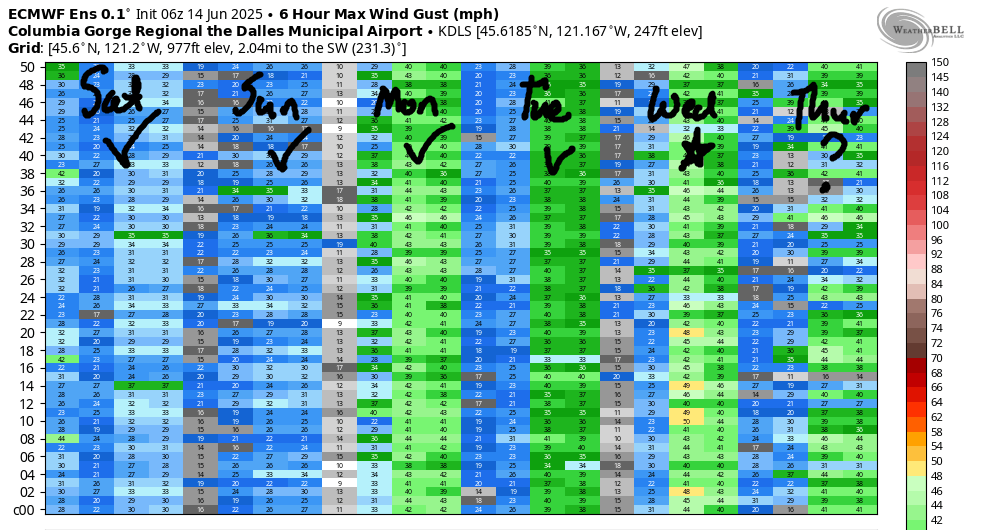
Hi friends! Wow. Yesterday we all saw what’s possible when offshore high pressure combines with stabilizing clouds on the west side and heat in the desert. Nuking! Massive swell! Blowing smoke! Huge smiles! Lesser wind is forecast today and tomorrow, but it’ll still be enough to get many of you on the river. Stronger wind returns on Monday with the passing of a weak system. Looking at the extended Gorge wind forecast via the ECMWF ensemble, we see wind every day through at least next Saturday. Before I forget again: folks, if there is fire fighting air support scooping from the river near you, you should not be there. Your presence can disrupt fire fighting operations. That means Doug’s Beach is a questionable choice for the duration of the Rowena Fire – please be respectful of the fire crews and those who’ve lost their homes and find another place to play if you see choppers and planes scooping. Also, drones are not allowed within the fire perimeter or nearby areas.
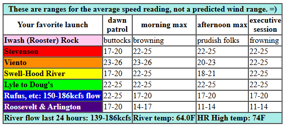
On to today’s forecast: Saturday started with pressures of 30.16/30.06/30.03 for gradients of 0.10 (pdx-dls) and 0.03 (dls-psc). Portland was partly cloudy to start, but is forecast to clear (it did not yesterday, which is why the wind was so strong). TJ’s Dawn Patrol today was 13-16mph most areas with Viento and the Doug’s area over-performing at 21-24. Models suggest we’re headed for 22-25 from Stevenson to Mosier this morning with 22-25 from Stevenson to Avery this afternoon. Rufus maxes out at 17-20, and areas east of Rufus will be under 15mph. If the metro area clears, and it likely will, the Swell-Hood River zone will drop to 17-20ish late morning or early afternoon. Models do hint at a return to gusty 21-24 for that zone this evening after 5pm. River flow over the last 24 hours was 139-186kcfs, river temp is 64.0F, and high temp forecast is 74F for Hood River and 78F for Arlington.

tomorrow’s gorge wind forecast
A warm night in the desert and cool, cloudy conditions in the metro area give TJ’s Dawn Patrol a nudge on Sunday: 23-26 is the call prior to 9am from Viento to Mosier. After that, as the metro area clears, westerlies drop to 19-22 and fill in from Stevenson to Mosier for the morning session. Afternoon wind lingers at 19-22 on the west side and fills in to Rufus at 19-22. East of there: 11-14 at Arlington. High temp for Sunday is 81F for Hood River and 84F for Arlington.
extended Gorge wind forecast
A weak shortwave moves through on Monday and pours reinforcing cold air in to western Oregon/Washington. If we get lucky, this will be enough to keep the west side cloudy. As of now, that’s not what the models are saying, but we’ll still cross our fingers. We’ll be missing the offshore high on Monday, but we should still see strong wind. For now, let’s call it 26-29 from Viento to Mosier for TJ’s Dawn Patrol. If the metro area clears late morning, the strongest wind shifts east: 28-31 from Mosier to Arlington while Swell drops to 20-23. This is the sort of setup where clouds may beat the models. Fingers crossed! Stevenson: unknown due to cloud uncertainty. Afternoon wind rises to 29-33 from Mosier to Arlington with 27-30 at Threemile and gusty 20-23 from Stevenson to Hood River. Unless the metro area holds on to low clouds… High temp: 76F for Hood River and 81F for Arlington.
Looking deeper into the week… lighter wind is forecast on Tuesday, but we should still touch the low 20s. There’s quite a bit of model spread for Wednesday; the GFS deterministic is not impressed and only offers up 20mph or so. The ECMWF ensembles, on the other hand, are quite optimistic and think we’ll see upper 20s. Models agree on mid to upper 20s, possibly low 30s for Thursday. Moderately strong westerlies linger in the ensembles through next Saturday… Sorry, Walt, but you do not get a rest day any time soon. Same to you, Andre. Have a great day today, everyone. I’ll see you on the Nch’i Wana!
Was that helpful? I knew it was! Guess what? All of this crucial work – from your personal wind and snow reports to the invaluable TATAS updates – is made possible by my relentless efforts. Maintaining this labor of love isn’t easy. Each daily forecast takes hours. Website hosting, weather model access, and back-end admin work takes time and money. That’s where you come in.
YOUR CONTRIBUTION MAKES A DIFFERENCE
- SUPPORT ACCURATE, HYPER-LOCAL WEATHER FORECASTING
- ENABLE ACCESS FOR ALL, EVEN THOSE WITH LESS MEANS
- SUPPORT A COOL HUMAN WHO WORKS HARD SO YOU CAN PLAY
Take a moment to click one of the buttons below. Donate $19.99 or more (how much does this forecast enhance your life?) and get the email in your inbox. Whether it’s a renewing subscription (auto-renew) or a one-time donation, every contribution makes a real difference. Help me keep this labor of love alive, so we can all continue playing, commuting, and living in the Gorge with peace of mind and the best weather forecasts possible. Thank you!


Hood River, Oregon 97031


JONES BEACH, SAUVIE ISLAND, & COAST FORECAST
Wind northerly unless otherwise indicated. For coast, it’s North/Central/South with the “central” at approximately Florence. Swell forecast from NWS for central coast. Jones: westerly unless otherwise stated. Sauvie Island: northerly unless otherwise stated. Saturday: 15-20/20/30, N swell 5′ at 6 seconds. Sunday: 20/20/25-30, NW 2′ @ 11. Monday: LTW?LTW/N10-15, W 3′ @12. Jones Saturday: 19-22. Sunday: 23-26. Monday: 17-20. Sauvie Island Saturday: 15-18 > 5pm. Sunday: 14-17 > 5pm. Monday: 12-15.
BARE BONES HOOD RIVER WEATHER FORECAST
Clear sky all day. Temps start in the low 50s and rise to the mid 70s. Moderately strong westerlies. No rainbows. Sunday will be partly cloudy then clear. Temps start in the upper 40s and rise to the low 80s. Moderately strong westerlies. No rainbows. Monday starts with high clouds and turns clear. Temps start in the low 50s and rise to the mid 70s. Strong westerlies. No rainbows.
TEMIRA’S AWESOME TRAVEL ADVISORY SERVICE
HYPERLOCAL WEATHER FORECAST FOR THE COLUMBIA GORGE
THE DALLES, HOOD RIVER, WHITE SALMON, TROUT LAKE, STEVENSON, CASCADE LOCKS, PARKDALE, ODELL, HUSUM, BZ, MILL A, WILLARD, GOLDENDALE, RUFUS, ARLINGTON, boardman

Good morning, neighbors! I’m getting a late start today thanks to leading a Canadian meditation group this morning. But a late start is okay – we all deserve to do meaningful stuff early in the morning, or heck, at any time of day. Speaking of… If you want to stand up for democracy and for communities that care for and welcome folks of all backgrounds and orientations, show up for a demonstration today: noon in Bingen, Stevenson, Hood River, and The Dalles. And do it with care and kindness in your heart – coming from a place of hate and fear will poison you and poison those you care about. Promise. Spoken from experience.
Glenwood’s start to the day and today’s Gorge weather forecast
Speaking of caring… muster up some care for Glenwood: 33 degrees this morning! That’s cold enough to rip steam from a cup of coffee and cold enough to require a warm pair of Bernie Sanders meme mittens to sit outside in nature while enjoying said cup of coffee. The rest of us started the day around 50 degrees. We’ll finish up in the low 70s (west) and upper 70s (east). West wind rises to 20-25mph between Stevenson and Wishram this afternoon with 15-20 near Rufus and 10-15 east to the Arlington Triangle. A few low clouds will be present on the west side this morning, but they’ll get lost in thoughts and disappear this afternoon. We all end up with clear sky.
Sunday’s Gorge weather forecast
Sunday looks rather similar, but warmer afternoon temps will result in, well, more warmth and more ball sweat and boob sweat but also less wind. Temps kick off around 50 degrees. They rise to 80 (west) and 85 (east). Westerlies will be 25mph from Viento to Mosier in the morning with 20mph from Stevenson to Biggs in the afternoon. Arlington Triangle: 10-15mph.
extended gorge weather forecast
Cooler weather – 75 to the west and 80 to the east – is forecast on Monday along with some high clouds and lots of west wind: 30mph from Stevenson to Arlington by afternoon. Tuesday, Wednesday, Thursday, Friday, Saturday: increasingly cool and breezy every day. By Saturday, high temps might be below 70 degrees even in The Dalles.
Now, let’s turn our attention to rain. Glorious rain! West of maybe Viento or so, there’s a wee chance of sprinkles Wednesday. Next weekend, models are more optimistic (or pessimistic, if you’re a cherry farmer) about rain. They’re quite sure the Cascades and west part of the Gorge will see a wetting rain. They’re pretty sure The Dalles will see no more than a trace. Locations between Stevenson and The Dalles are up in the air for moisture amounts. As of now, it looks like the system will come in from the WNW, which usually results in some rain on the west side of Hood River and less farther east. If this system were coming from the south, widespread wetting/soaking rain would be more likely. For now, chances of cherry-soaking seem low, and temps also seem quite cool, but we’re gonna watch this real closely. Safe travels. -TATAS
HEY! DON’T STOP READING! Is this community-focused forecast helpful to you? It sure is! It takes me a couple hours a day to write. Please join your friends and neighbors in contributing to keep it going. Venmo: @thegorgeismygym PayPal: twomirrors@gmail.com USPS: Temira / PO Box 841 / Hood River, Oregon 97031 You can test out the forecast subscription for a few days for free by signing up below. Easy! Do it!
