

GORGE WIND FORECAST
If you’re still seeing yesterday’s and it’s after 9am, try opening this in an incognito window
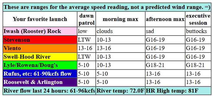
today’s gorge wind forecast
Hi friends! And hello from Cloud Mountain Retreat Center where I’m helping out one of my teachers with their retreat. It’s pretty awesome. I just have time for a quick Gorge wind forecast today, but I”ll toss some general weather in there too.
Today kicked off with sunshine in the Gorge and clouds in the metro area. Early pressures were 29.94/29.89/29.87 for onshore gradients of 0.05/0.02, just enough for a light west breeze. As a low offshore sends a cold front this way today, we’ll see the wind pick up. For the morning hours, westerlies rise to 13-16mph from Viento to the White Salmon Bridge with 10-13mph near Stevenson and also east to Rufus. Late morning sees the wind pick up to gusty 16-19mph between Stevenson and Doug’s with 11-14mph at Rufus. Mid-afternoon: busty 16-19mph from Stevenson to Hood River with gusty 18-21mph from Moiser to Doug’s. The zone between Maryhill and Arlington joins in at 13-16mph late afternoon as the front draws closer. River flow over the last 24 hours was 61-96kcfs, river temp is 72.0F, and high temp forecast is 81F for Hood River and 86F for The Dalles. After a sunny day, high clouds move in.
RIVER FLOW FOR SITES BETWEEN AVERY (EAST OF THE DALLES) AND RUFUS: CLICK HERE FOR JOHN DAY DAM FLOW.
RIVER FLOW FOR SITES BETWEEN STEVENSON AND DOUG’S BEACH (WEST OF THE DALLES): CLICK HERE FOR THE DALLES DAM FLOW

tomorrow’s gorge wind forecast
Sunday brings us some wind, but it starts off with drizzle all the way from Stevenson to the Tri-Cities. Early wind will be under 10mph all through the Gorge, except east of Arlington, where they may be upper teens to low 20s. By late morning, we should have 14-17mph from Stevenson to Arlington. Afternoon: 14-17mph from Stevenson to Doug’s with gusty 24-27mph from Avery to Arlington. Remember that those eastern Gorge sensors read high compared to the Swell sensor. 24-27mph out east is about 18-22mph at Swell. High temp: 69F for Hood River and 75F at Rufus with rain through 11am.
extended Gorge wind forecast
Monday sees high pressure build across the region. This gives us light west wind to start and light easterlies, perhaps 10mph between Rooster and Viento, to finish. Not much, eh? High temp: 78F all across the region. Stronger east wind is forecast on Tuesday as a heat low sets up over the Willamette Valley. As of this morning, it looks like easterlies will be 25mph or so at Rooster, Stevenson, Home Valley, and Viento for the morning. A trough (cool air) approaches the coast on Wednesday and sends a surge of marine air into the west side. The heat low slides to the east. While there’s still some uncertainty in the ensembles, most of them (and the deterministic GFS) give us a big day on the river. Fingers crossed. Have a great weekend, y’all. I’ll see ya on the Nch’i Wana (but not until I’m back)!
