

GORGE WIND FORECAST
If you’re still seeing yesterday’s and it’s after 9am, try opening this in an incognito window
today’s gorge wind forecast
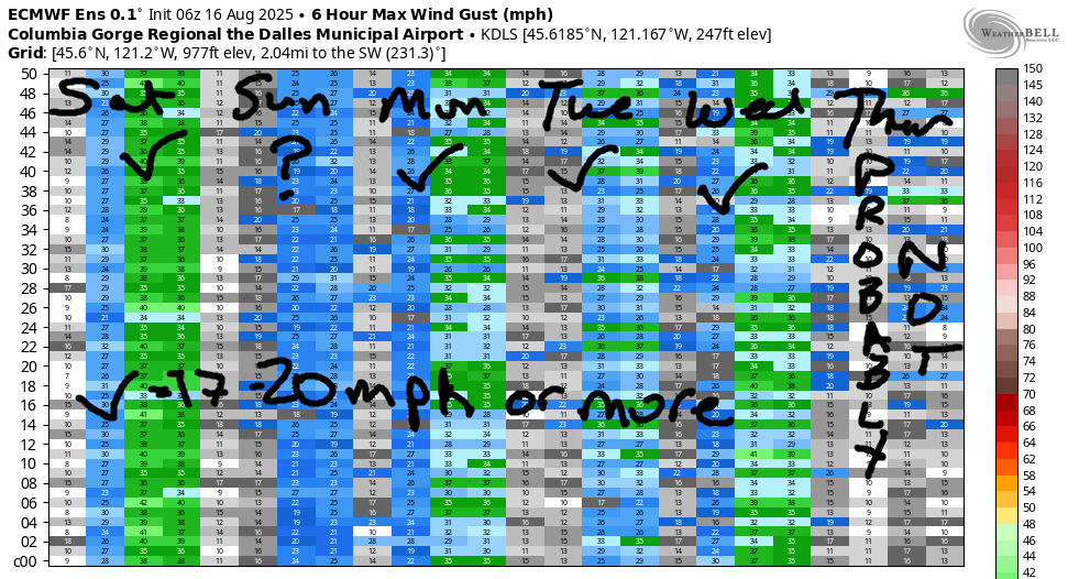
Hi friends! Breezy, cool-ish weather is on tap Sunday through Wednesday. While it won’t be anywhere close to “nuking”, we should have 17-20mph or more each day. Somewhere. Uncertainty rises on Thursday and Friday thanks to uncertainty about heat and the location of the hottest temps. By Saturday or Sunday, we’re likely to be back in the west wind pattern. Before I forget… today and tomorrow is the Gorge Challenge paddle races. They take place at Viento and the Hood River Waterfront Park. Good luck to the racers. If you’re not racing, perhaps choose a different venue for your fun today.
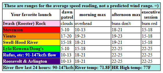
Saturday starts off with a cold front moving through. Deep low clouds are present on the west side, and mixed clouds are moving eastward. We’ll eventually see the east side (mostly) clear while clouds are slower to break up in the west. 8am gradients (I’m running late this morning thanks to my meditation group) were 29.98/29.91/29.89, but they’re changing rapidly as this system moves through. At 8am, the Viento-Hatch zone was reading 19-23mph on the iWind/iKite network. Everywhere else was reading 10-13mph or less. As the clouds burn back and the front moves east, westerlies fill in at 18-21mph from Stevenson to Arlington. In the afternoon, Mosier-Arlington picks up to 22-25mph and Stevenson-Hood River drops to 15-18mph. River flow over the last 24 hours was 90-147kcfs, river temp is 71.8F, and high temp forecast is 77F for Hood River and low 80s in the desert.
RIVER FLOW FOR SITES BETWEEN AVERY (EAST OF THE DALLES) AND RUFUS: CLICK HERE FOR JOHN DAY DAM FLOW.
RIVER FLOW FOR SITES BETWEEN STEVENSON AND DOUG’S BEACH (WEST OF THE DALLES): CLICK HERE FOR THE DALLES DAM FLOW

tomorrow’s gorge wind forecast
Sunday sees another weak system approach, which will impact wind quality and quantity. The day starts “light”, which means less than 10mph. Westerlies slowly, steadily build. Midday wind will be 12-15mph from Stevenson to Swell with 7-10mph to the east. Afternoon: 16-19mph from Stevenson to Hood River with 12-15mph from Mosier to Doug’s. High temp: 78F for Hood River.
extended Gorge wind forecast
Marine clouds set up on Monday morning on the west side. Out east, lingering mid-level clouds in the morning give way to sunshine in the afternoon. Better thermal support exists on Monday than over the weekend, and this probably leads to stronger wind. For now, we have this forecast: 18-21mph from Stevenson to Arlington to start with 23-26mph at Viento. Stevenson-Doug’s rises quickly to 20-23mph. Afternoon: probably a dip at Swell if the clouds fully clear. Otherwise: 22-26mph from Mosier to Rufus (remembering that the Rufus sensor reads high compared to Swell). High temp: 77F in Hood River and 88F at Rufus.
Tuesday looks like 17-20mph+, and Wednesday looks like 21-24mph. After that, there’s quite a bit of uncertainty, but easterlies are likely both Thursday and Friday. Looking to the weekend, we have huge range in the highs on Saturday (86-98F for The Dalles). This leads to an impossible wind forecast. Generally speaking, we’ll see a cooldown sometime in the (next) Saturday through Tuesday time period, which means we’ll see stronger westerlies in that time frame too. That’s it for today. Hope to see you on the Nch’i Wana!
Was that helpful? I knew it was! Guess what? All of this crucial work – from your personal wind and snow reports to the invaluable TATAS updates – is made possible by my relentless efforts. Maintaining this labor of love isn’t easy. Each daily forecast takes hours. Website hosting, weather model access, and back-end admin work takes time and money. That’s where you come in.
YOUR CONTRIBUTION MAKES A DIFFERENCE
- SUPPORT ACCURATE, HYPER-LOCAL WEATHER FORECASTING
- ENABLE ACCESS FOR ALL, EVEN THOSE WITH LESS MEANS
- SUPPORT A COOL HUMAN WHO WORKS HARD SO YOU CAN PLAY
Take a moment to click one of the buttons below. Donate $19.99 or more (how much does this forecast enhance your life?) and get the email in your inbox. Whether it’s a renewing subscription (auto-renew) or a one-time donation, every contribution makes a real difference. Help me keep this labor of love alive, so we can all continue playing, commuting, and living in the Gorge with peace of mind and the best weather forecasts possible. Thank you!


Hood River, Oregon 97031


JONES BEACH, SAUVIE ISLAND, & COAST FORECAST
Wind northerly unless otherwise indicated. For coast, it’s North/Central/South with the “central” at approximately Florence. Swell forecast from NWS for central coast. Jones: westerly unless otherwise stated. Sauvie Island: northerly unless otherwise stated. Coast Saturday: W5-10/LTW/N10-15, W swell 7′ @ 10 seconds and SW 2′ at 14 seconds. Sunday: LTNW/NW5-10/NW5-10, W 6′ @ 10. Monday: LTW/LTW/N5-10, SW 2′ @ 13. Jones Saturday: LTW. Sunday: 9-12. Monday: 7-10. Sauvie Island Saturday: LTN. Sunday: 7-10. Monday: LTV.
BARE BONES HOOD RIVER WEATHER FORECAST
Clouds today with rain from mid-morning on. Temps start in the low 40s and rise to the low 50s. Calm wind. 11% chance of rainbows. Thursday will be showery all day. Temps start in the upper 30s and rise to the upper 40s. Moderate westerlies. 99.99% chance of rainbows. Friday will be High overcast and dry in the morning with rain in the afternoon. Temps start in the low-mid 30s and rise to the mid 40s. Light easterlies. 4% chance of rainbows.
TEMIRA’S AWESOME TRAVEL ADVISORY SERVICE – SATURDAY 8/16
HYPERLOCAL WEATHER FORECAST FOR THE COLUMBIA GORGE
THE DALLES, HOOD RIVER, WHITE SALMON, TROUT LAKE, STEVENSON, CASCADE LOCKS, PARKDALE, ODELL, HUSUM, BZ, MILL A, WILLARD, GOLDENDALE, RUFUS, ARLINGTON, boardman
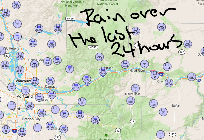
Good morning, neighbors! Our BIG RAINSTORM did a big fizzle overnight except for areas west of Wyeth. Rain totals so far ranged from a trace in many areas to 0.06” for The Dalles, 0.32” in Stevenson, and 1.04” (JEALOUS!) for Washougal. Up in the mountains, Meadows picked up 0.5” (yay), and Timberline received 0.67”. Rain tapers off quickly today. After that, we’re left high and dry for (probably) at least the next 10 to 14 days. Cool weather lingers through midweek. End of the week: warmer, potentially hot, but not super-duper-hot. Cooling returns next Saturday or Sunday or Monday… somewhere in that window.
GLENWOOD THIS MORNING
Despite the poor rainfall showing last night, it’s muggy AF this morning (DEWPOINT 61!!!), which left us with warm temps to start. Glenwood boasted 63F this morning, which is really, really, really warm for a Glenwood morning. Not knowing what to do with all this warmth, the folks in Glenwood took it into their hearts and radiated it back into the world as kindness and care for all beings.
TODAY’S GORGE WEATHER FORECAST
The rest of us were generally in the 65-70F range and cloudy to start today. Rain ends from west to east today. After 8am, those of us west of The Dalles will be dry. After 11am, those of us west of Rufus will be dry. A couple hours later, everyone to the east dries out too. West wind picks up to 15-20mph from Stevenson to Rufus late morning and builds to 20-25mph between Mosier and Arlington this afternoon. Highs range from 77F (west side) to 82F (The Dalles) and 85F (desert). Did I mention it will be muggy? It will, especially in the morning. Once this weather system clears the area, mugginess decreases.
SUNDAY’S GORGE WEATHER FORECAST
Overnight, we’ll have a mix of clouds on the west side and clear sky to the east. With 850mb temps at 10C and light wind to start Sunday, it’ll be a cool morning anywhere with clear sky. If Glenwood manages to clear, we could see temps dip into the upper 30s there! Most other folks start the day at 50-60F. Afternoon brings some high clouds with temps ranging from 78F (west) to 83F (The Dalles) and 87F (WatermelonLand). Wind will be under 10mph to start. It rises to 15-20mph from Stevenson to Hood River with 15mph from Mosier to The Dalles in the afternoon.
EXTENDED GORGE WEATHER FORECAST
In a fun twist (for me, because I get to type less), Monday, Tuesday, and Wednesday look rather similar to Sunday. Each day starts with a few clouds to the west. Each day starts with sun to the east. Each day finishes rather sunny. West wind will be within a few mph of 20mph west of The Dalles, and unless something changes, will be less than 15mph east of The Dalles. Temps hang in the low 80s to the west and 90F out in the desert. A warming trend begins on Thursday and sticks around Friday and maybe Saturday. After that, model uncertainty explodes (like my butt after eating cherries), and temps (etc) are unclear. That’s enough for this morning. Safe travels. -TATAS
HEY! DON’T STOP READING! Is this community-focused forecast helpful to you? It sure is! It takes me a couple hours a day to write. Please join your friends and neighbors in contributing to keep it going. Venmo: @thegorgeismygym PayPal: twomirrors@gmail.com USPS: Temira / PO Box 841 / Hood River, Oregon 97031 You can test out the forecast subscription for a few days for free by signing up below. Easy! Do it!
