

GORGE WIND FORECAST
If you’re still seeing yesterday’s and it’s after 9am, try opening this in an incognito window
today’s gorge wind forecast
Hi friends! Ugh. It’s been a rough few days in Temira-land. I’ve been enjoying(?) some sort of GI virus. I highly recommend you do not get this thing. I’ve been mostly flat on my back for a couple of days. Just trying to stay upright enough to get a forecast out. Wind-wise, nothing’s happening today, but there’s a chance tomorrow. After that: not much for a few days.
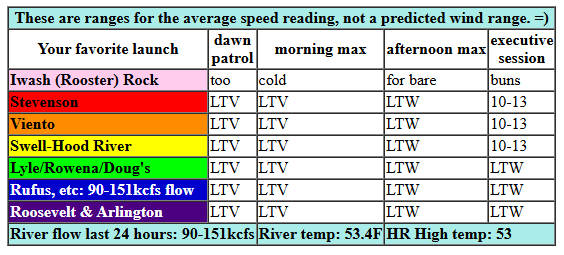
Saturday kicks off with light/variable wind and very light onshore gradient. The wind turns light westerly this afternoon, under 10mph, and picks up to perhaps 10-13mph from Stevenson to the Hatch after 4pm. River flow over the last 24 hours was 90-151kcfs, river temp is 53.4F, and high temp forecast is 53F.
RIVER FLOW FOR SITES BETWEEN AVERY (EAST OF THE DALLES) AND RUFUS: CLICK HERE FOR JOHN DAY DAM FLOW.
RIVER FLOW FOR SITES BETWEEN STEVENSON AND DOUG’S BEACH (WEST OF THE DALLES): CLICK HERE FOR THE DALLES DAM FLOW

tomorrow’s gorge wind forecast
On Sunday, a weak weather system swings through in the morning and weak high pressure builds offshore in the afternoon. The day starts with 10-13mph from Viento to the Hatch and also from Rufus to Arlington with less wind from Hood River to Avery. We’ll see a slow build to 16-19mph from Stevenson to Doug’s with 19-22mph from Avery to Arlington. High temp: 50F.
extended Gorge wind forecast

Not much is happening in the extended forecast. Light westerlies, under 10mph, are forecast on Monday. Tuesday brings easterlies that max out around 25mph. Wednesday looks light and variable. That’s all I’ve got for you now. Gonna keep plugging away at the rest of forecasts in the hopes I can get this out before I end up horizontal again!
Was that helpful? I knew it was! Guess what? All of this crucial work – from your personal wind and snow reports to the invaluable TATAS updates – is made possible by my relentless efforts. Maintaining this labor of love isn’t easy. Each daily forecast takes hours. Website hosting, weather model access, and back-end admin work takes time and money. That’s where you come in.
YOUR CONTRIBUTION MAKES A DIFFERENCE
- SUPPORT ACCURATE, HYPER-LOCAL WEATHER FORECASTING
- ENABLE ACCESS FOR ALL, EVEN THOSE WITH LESS MEANS
- SUPPORT A COOL HUMAN WHO WORKS HARD SO YOU CAN PLAY
Take a moment to click one of the buttons below. Donate $19.99 or more (how much does this forecast enhance your life?) and get the email in your inbox. Whether it’s a renewing subscription (auto-renew) or a one-time donation, every contribution makes a real difference. Help me keep this labor of love alive, so we can all continue playing, commuting, and living in the Gorge with peace of mind and the best weather forecasts possible. Thank you!


Hood River, Oregon 97031


MT HOOD SNOW FORECAST

Hey skiers and snowboarders! Apologies for the missing forecast the last few days. I’ve been quite sick and not able to remain upright for the time required to get it done. It’s probably just as well – not much happening up on the slopes. We’ll have a brief period of snow Sunday into Monday, and then it’s back to warm and wet through the 30th of the month or so. After that, all bets are off – the Euro ensemble takes us colder, and the GFS ensemble hovers right around the snow/rain temp zone.
Saturday will be sunny to start then high overcast. The free air freezing level will be 10,000′ all day and will fall to 8000′ overnight. Wind: SW 10 this morning, W 10 this afternoon, and WSW 20 overnight. Sunday starts high overcast, turns rainy midday, and cools off enough for snow in the evening. The snow level starts around 8000′, falls to 3500′ around 4pm, and drops as low as 1500′ after midnight. About 0.5” water equivalent (WE) is forecast during the day. The last bit of that, perhaps 0.1” to 0.2”, will fall as snow at 5000′. Call it an inch of wet snow. After 4pm, another 0.1” to 0.2” WE is forecast for another 1-2” of snow. Wind: WSW 20-25 in the morning, W 35 in the afternoon, and WNW 25-30 after midnight.
A few lingering flurries are possible Monday morning followed by another round of light snow in the afternoon. The snow level will be around 2000′ all day with the free air freezing level dropping to 0-500′ overnight under thin high clouds. About 0.1” WE is forecast during the afternoon for an inch or so of snow. Wind: WNW 25-30 in the morning, W 15-20 in the afternoon, and light southerly overnight.
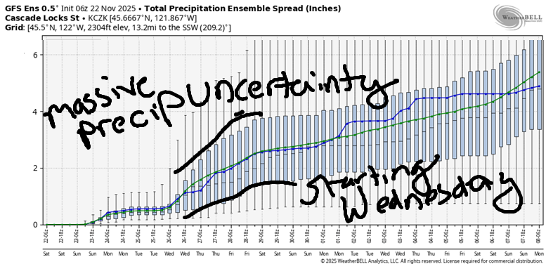
The next round of precipitation starts early Wednesday and continues through late Friday. This system (probably) taps into an atmospheric river, but there’s a lot of uncertainty about total moisture. As of this morning, the Euro has 1.5-2.5” of rain. The GFS range is even larger, which about 15% of the members calling for no precipitation and others calling for 3+ inches. Looking deeper into the future, temps remain too warm for significant snow through the 30th of November. Beyond that, model uncertainty skyrockets, so I’ll end this forecast there. Hope to see you on the snow soon!
BARE BONES HOOD RIVER WEATHER FORECAST
Nothing this morning and partly high overcast this afternoon. Temps start in the mid 30s and rise to the mid 50s. Light westerlies. No rainbows. Sunday will be cloudy with drizzle. Temps start in the upper 30s and rise to 50. Moderate westerlies. 94% chance of rainbows. Monday will be partly cloudy then mostly sunny. Temps start in the mid 30s and rise to the upper 40s. Light westerlies. 3% chance of rainbows.
TEMIRA’S AWESOME TRAVEL ADVISORY SERVICE
HYPERLOCAL WEATHER FORECAST FOR THE COLUMBIA GORGE
THE DALLES, HOOD RIVER, WHITE SALMON, TROUT LAKE, STEVENSON, CASCADE LOCKS, PARKDALE, ODELL, HUSUM, BZ, MILL A, WILLARD, GOLDENDALE, RUFUS, ARLINGTON, boardman
Good morning, neighbors! I’m going to recommend you skip the GI virus that’s going around. It’s had me flat on my back for the better part of two days now. Unpleasant, for sure. Fortunately, there hasn’t been much “weather” happening, so hopefully you haven’t missed me too much! General weather picture for the next week or so: dry today, drizzly west of The Dalles on Sunday, mostly dry most places Monday, dry Tuesday, rainy starting Wednesday and continuing into Buy Nothing Friday.
Looking around the region this morning, a select and not-lucky crowd is stuck under the Nothing, and some roads will have tricky driving due to the dense fog. Glenwood, however, is not foggy. It’s clear. I know this because it bottomed out (Glenwood is a bottom, not a top) at 26 degrees this morning. Most other locations away from the Nothing are in the low 30s. Folks under the Nothing or higher in elevation are warmer. Middle Mountain, for example, was reading 39 degrees to start the day.
Nothing burns off this afternoon. All locations eventually end with a few high clouds. High temps will be in the low 50s along the river except way, way out east, where they’ll never make it past 50. Wind: light and variable most of the day with light westerlies this afternoon, strongest from Stevenson to Hood River where we’ll have 10mph or so.
A weather system moves in overnight and sets up drizzle on Sunday. Expect light drizzle as far east as Lyle most of the day, into early evening. The Dalles stays dry most of the day with a little drizzle starting right around sunset. South Wasco: maybe a little drizzle early afternoon, but mostly dry otherwise. Temps max out near 50 for all lowland locations. Wind will be 10mph west of Hood River to start the day with lighter wind to the east. The day finishes with 15-20mph between Stevenson and Murdoch and 20mph from The Dalles to the Arlington Triangle. Overnight, the snow level falls from 3500′ to 1500′ as 850mb temps drop to -4C.
This sets us up for a Monday morning with a few snowflakes in areas like Mill A, Parkdale Underwood, Snowden, Trout Lake and anywhere else above 1500′ and west of Snowden. It’s unlikely we’ll see enough snow for even the lightest coating. In the lowlands, we’ll have drizzle from 10am-4pm west of Underwood. Lowland temps start in the mid 30s and rise to the 48-51F. Wind: light westerly accompanied by rainbows.
Dry weather is forecast Tuesday into Wednesday. Sometime Wednesday, rain returns. It sticks around, on-and-off, through Friday evening. Models are all over the place on how much rain we’ll receive. For now, let’s just call it “wet” and leave it there so I can go back to bed. Stay well, my friends! Safe travels. -TATAS
HEY! DON’T STOP READING! Is this community-focused forecast helpful to you? It sure is! It takes me a couple hours a day to write. Please join your friends and neighbors in contributing to keep it going. Venmo: @thegorgeismygym PayPal: twomirrors@gmail.com USPS: Temira / PO Box 841 / Hood River, Oregon 97031 You can test out the forecast subscription for a few days for free by signing up below. Easy! Do it!
JONES BEACH, SAUVIE ISLAND, & COAST FORECAST
ON WINTER VACATION UNLESS DESPERATELY NEEDED.
