

MT. HOOD WEATHER FORECAST

Hey skiers and snowboarders! While we were hoping for a couple feet of snow, we picked up a foot. We’ll take it! That’s enough to vastly improve conditions on the lift-serve side of things. Down in the Nordic zones, things will be slower and softer. Mt. Hood weather for the next week: intermittent light snowfall – an inch or two here and there, and cold temps. Snow surface today: powder interspersed with frozen granular areas (watch out for those rock-hard moguls under the fresh) off the groom, and packed powder with some wind-scoured granular areas on the groom. Parks: mixed bag, probably. Nordic: packed powder, violet wax (or skins/scales), with accumulating new on top.
Saturday starts off with a little orographic (terrain-driven) snowfall, but we should see the sun come out. The snow level starts around 2000′ and falls to 1000′ this morning. Overnight, the free air freezing level drops all the way down to 0′. Temps drop from the mid 20s at 5000′ this morning to 20F or so this afternoon and evening. About 0.1” water equivalent (WE) is forecast today, for an inch of additional powder. Ditto overnight. Wind: W 35 in the morning, WSW 25-30 in the afternoon, and W 20 overnight.
Liking this forecast?
Sunday will be cloudy down low (6000′ and less) and clear up high to start. Sunshine takes over midday, and snow returns in the afternoon. The snow level will be 0′ in the morning, 1000′ in the afternoon, and 0′ overnight. Temps at 5000′ will be in the mid to upper teens. About 0.1” WE is forecast in the afternoon for an inch of new snow. Same overnight. Wind: W 20 in the morning, SW 20-35 in the afternoon, and W 10 after midnight.
Continued flurries are possible on Monday. Models have clouds hanging around in the lower elevations, 6000-7000′ deep, for most of the day and night. That could result in some freezing fog. Snow level: 0′ all day with temps at 5000′ in the mid teens. Just a trace of snow is forecast. Wind will be W 10 in the morning, E 10 in the afternoon, and variable to 10 after midnight.
Generally speaking, the rest of the week looks cold – the snow level hovers around 0′. There’s a fair bit of discrepancy between the Euro and the GFS on how cold it will get, and this has some impact on how dry it will be. For now, let’s just call it “cold” with excellent packed powder groom and park and Nordic conditions all the way through the week. See you on the snow!
Was that helpful? I knew it was! Guess what? All of this crucial work – from your personal wind and snow reports to the invaluable TATAS updates – is made possible by my relentless efforts. Maintaining this labor of love isn’t easy. Each daily forecast takes hours. Website hosting, weather model access, and back-end admin work takes time and money. That’s where you come in.
YOUR CONTRIBUTION MAKES A DIFFERENCE
- SUPPORT ACCURATE, HYPER-LOCAL WEATHER FORECASTING
- ENABLE ACCESS FOR ALL, EVEN THOSE WITH LESS MEANS
- SUPPORT A COOL HUMAN WHO WORKS HARD SO YOU CAN PLAY
Take a moment to click one of the buttons below. Donate $19.99 or more (how much does this forecast enhance your life?) and get the email in your inbox. Whether it’s a renewing subscription (auto-renew) or a one-time donation, every contribution makes a real difference. Help me keep this labor of love alive, so we can all continue playing, commuting, and living in the Gorge with peace of mind and the best weather forecasts possible. Thank you!


Hood River, Oregon 97031


GORGE WIND FORECAST

Hi friends! Light to moderate westerlies stick around for a couple days, and then we’re probably back into some sort of colder, east wind setup for a while. By cold, I mean probably sub-freezing. But not today. We start Saturday with pressures of 30.01/29.93/39.87 for gradients of 0.08/0.06. Models aren’t particularly excited today – the setup isn’t great. However… We could see 15-18mph from Stevenson to Hood River for a few hours late morning with a shot at 20-23 from Avery to Rufus or Arlington for a few hours this morning. The wind drops to 10-13mph everywhere this afternoon. River flow over the last 24 hours was 91-140kcfss, river temp is 39.92F, and high temp forecast is 43F with light drizzle in the morning, a dry and partly cloudy spell midday, and rain as far east as Rowena this afternoon.
The 12k model isn’t giving us much on Sunday – light/variable wind to start. There’s some hope of a brief period of very gusty 18-22 from Stevenson to Viento in the afternoon with perhaps very gusty 14-17 at Swell if we’re super lucky. High temp: 40F with intermittent flurries/drizzle. Monday starts calm and turns light easterly. Beyond Monday, there’s disagreement between the GFS and the ECMWF on the extent of cold air pushing in from the east side. This would impact the wind strength. If the GFS wins, the wind will be stronger, but daytime temps will barely break freezing. You’re probably looking for a different activity than water sports for next week! Stay warm out there!
BARE BONES HOOD RIVER WEATHER FORECAST
Partly cloudy sky today with intermittent showers in the morning and snain in the evening. Temps start in the upper 30s and rise to the low 40s. Moderate westerlies. 99% chance of rainbows. Sunday will be partly to mostly cloudy with light snow then snain and drizzle. Temps start in the upper 20s and rise to 40 or so. Light westerlies. 79% chance of rainbows. Monday will be partly cloudy with just a few flurries. Temps start in the mid 20s and rise to the mid 40s. Light easterlies. No rainbows.
TEMIRA’S AWESOME TRAVEL ADVISORY SERVICE (DETAILED GORGE WEATHER FORECAST)
Good morning, neighbors! Reality really isn’t agreeing with my forecast right now – where I said it would snow (Parkdale and other places), there was freezing rain, which doesn’t make any sense at all given the setup. Fortunately, forecasting gets easier from here on out. Colder temps set us up for icy roads and a little bit of snow here and there. Chicken Stock Warning is still a go for next week. Will we be ice skating at river level? Depends on whether the GFS or ECMWF is right about temps next week…
But first, let’s check in with Glenwood: 35 degrees with a dewpoint of 25 degrees. Not much to talk about there, but Husum is reading 30F. Watch out for black ice out and about this morning, and not just near Husum. Next up: Executive Order Of The Day. Today I proclaim, and sign with a Sharpie, this new rule: every person who works 36 hours a week or more shall be given at least 10 days of paid vacation and 11 paid holidays each year. This number shall be prorated for folks working less hours. 1099 contractors shall also be provided with paid vacations and holidays relative to the time they work. You’re welcome!
TODAY
Saturday kicks off with some flurries up high and rain down low. We all dry out this afternoon in the break between systems. Temps max out in the low 40s, and westerlies rise to 15-20mph. Tonight, a weak system tosses out a little snow confetti west of The Dalles… Underwood, Mill A, Trout Lake, Parkdale, Snowden and a few other associated areas might get an inch. The rest of you west of The Dalles just get a trace, and everyone else ends up with icy roads as temps fall below freezing everywhere tonight. Looks like some high clouds will stick around tonight on the south side while the sky clears to the north. Y’all on the north side will be CHILLY tomorrow morning.
SUNDAY
Sunday kicks off with icy roads, calm wind, partly cloudy sky to the west, clear sky to the east, and clear sky to the north. Enjoy the dry morning. Snain down low and snow up high is forecast as far east as Mosier from about 10am on into the evening. Expect sun to the east, and expect west wind at 15mph or so between Stevenson and Rufus. High temp: 40F after a upper 20s start in the lowlands.
MONDAY
Temps Monday morning will be in the mid 20s or less everywhere thanks to 850mb temps at -10C, calm wind, and partly cloudy sky. Glenwood’s low temp: very cold! A few scattered flurries are possible on Monday. Models are all over the place on high temps, so I’m not even going to guess. Easterlies pick up to 10-15mph in the afternoon, probably…
TUESDAY AND BEYOND
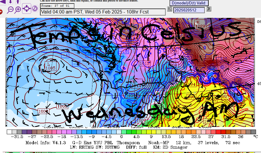
Starting Tuesday, there’s more range in the possibilities. Generally speaking, all of the possibilities indicate cold weather, but the GFS is a LOT colder than the Euro, about 10F colder for daytime highs. That’s 20F vs. 30F. I mean, look at the Wednesday morning temp forecast by the GFS. BRR! Either way, we’ll be seeing plenty of chilly weather this week. Towards the end of the week, the GFS starts to offer up some more impactful precipitation. The Euro is skeptical.
In the meantime, it’ll be a great week to use the Gorge as your refrigerator, and it might even be cold enough (especially in the morning) to toss everything from your chest freezer outside so you can defrost the freezer. Get that giant pot of soup stock bubbling, and set it outside to cool. And cross your fingers for the colder, drier solution if you want to ice skate. While you’re at it, check on your unhoused neighbors and make sure they have plenty of blankets. Maybe take them a warm drink. It’s definitely going to be cold enough, whichever model is correct, to put people at risk of cold-related illnesses and injuries. Safe travels. -TATAS
HEY! DON’T STOP READING! Is this community-focused forecast helpful to you? It sure it! It takes me a couple hours a day to write. Please jump in a contribute to keep it going. Venmo: @thegorgeismygym PayPal: twomirrors@gmail.com USPS: Temira / PO Box 841 / Hood River, Oregon 97031 You can test out the forecast subscription for a few days for free by clicking this link: https://subscribepage.io/YhevGc
