

GORGE WIND FORECAST
If you’re still seeing yesterday’s and it’s after 9am, try opening this in an incognito window
today’s gorge wind forecast
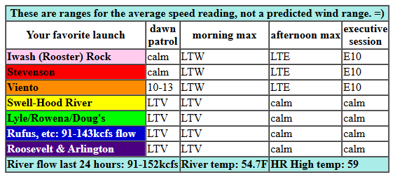
Hi friends! Not much going on today, but we have at least a chance of strong-enough westerlies on Monday. Saturday kicks off with light west gradients – 30.03/29.99 – and very light west wind. Expect calm wind midday and light easterlies after 4pm. River flow over the last 24 hours was 91-152kcfs, river temp is 54.7F, and high temp forecast is 59F.
RIVER FLOW FOR SITES BETWEEN AVERY (EAST OF THE DALLES) AND RUFUS: CLICK HERE FOR JOHN DAY DAM FLOW.
RIVER FLOW FOR SITES BETWEEN STEVENSON AND DOUG’S BEACH (WEST OF THE DALLES): CLICK HERE FOR THE DALLES DAM FLOW

tomorrow’s gorge wind forecast
Sunday brings easterlies with rain in the east wind zone. Expect 25mph early in the morning at both Stevenson and Iwash (Rooster) Rock. The wind drops quickly. After 1pm, we’ll have light westerlies all through the Gorge.
extended Gorge wind forecast
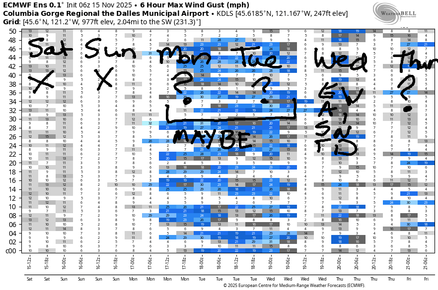
Monday brings a cold front through with high pressure building behind it. This carries the potential for westerlies after the rain finishes up. Ensembles are far from certain about this. While the GFS deterministic insists we’ll see mid 20s east of The Dalles, the ensembles do not. Given the setup, I think our best chance is from Viento to Doug’s. My fingers are crossed. Westerlies are possible again on Tuesday, but they look lesser than on Monday. High pressure builds inland on Wednesday and sets us up (probably) for all-day east wind with dry weather. Okie dokie. That’s as far into the future as I’m guessing. Have an awesome day today!
Was that helpful? I knew it was! Guess what? All of this crucial work – from your personal wind and snow reports to the invaluable TATAS updates – is made possible by my relentless efforts. Maintaining this labor of love isn’t easy. Each daily forecast takes hours. Website hosting, weather model access, and back-end admin work takes time and money. That’s where you come in.
YOUR CONTRIBUTION MAKES A DIFFERENCE
- SUPPORT ACCURATE, HYPER-LOCAL WEATHER FORECASTING
- ENABLE ACCESS FOR ALL, EVEN THOSE WITH LESS MEANS
- SUPPORT A COOL HUMAN WHO WORKS HARD SO YOU CAN PLAY
Take a moment to click one of the buttons below. Donate $19.99 or more (how much does this forecast enhance your life?) and get the email in your inbox. Whether it’s a renewing subscription (auto-renew) or a one-time donation, every contribution makes a real difference. Help me keep this labor of love alive, so we can all continue playing, commuting, and living in the Gorge with peace of mind and the best weather forecasts possible. Thank you!


Hood River, Oregon 97031


MT HOOD SNOW FORECAST

Hey skiers and snowboarders. Colder weather, cold enough for snow, arrives on Monday morning, and then the snow level bounces around next week. If I had to hazard a guess, I’d guess that neither Meadows, nor Skibowl, nor Teacup will be open by the end of next week. Yup, it’s the time of year when I start trying to guess opening day!
Saturday will be drizzly on Mt. Hood. The snow level will be around 10,000′ all day. Around 0.1” rain falls during the day with a trace this evening. Wind: W 25 this morning, SW 5-10 this afternoon, and S 10-15 overnight. Sunday will be sunny in the morning and rainy in the afternoon. The snow level starts at 10,000′, falls to 8500′ in the afternoon, and drops to 6000′ overnight. 0.1” rain is forecast in the afternoon. That’s followed by 0.4” overnight. Wind: S 10-15 in the morning, W 15-20 in the afternoon, and SW 15-20 overnight.
On Monday, the snow level drops from 6000′ early in the morning to 3000′ in the afternoon and 2000′ overnight. Most of the moisture will be done before midnight. During the daylight hours, about 0.2” water equivalent is forecast as mixed precip; 5000′ elevation could pick up an inch. Another 0.2” WE falls overnight for a couple more inches. Wind: SW 10-20 in the morning, NW 20-25 in the afternoon, and W 30 after midnight. A few more inches of snow are forecast on Tuesday, and then we return to a few days of dry weather (maybe). Beyond that: lots of uncertainty, but some hint of significantly colder temps combined with snow in the last week of November. Fingers crossed! Hope to see you on the skategroom soon!
BARE BONES HOOD RIVER WEATHER FORECAST
Clouds this morning. Partly cloudy later. Temps start in the mid 50s and rise to the upper 50s. Light westerlies. Then light easterlies. 2% chance of rainbows. Sunday will be dry and partly cloudy in the morning, cloudy in the afternoon, and rainy later. Temps start in the mid 40s and rise to the mid 50s. Light easterlies. 13% chance of rainbows. Monday will be cloudy with rain in the morning and dry weather in the afternoon. Temps start in the mid 40s and rise to the mid 50s. Moderate westerlies. 99.7% chance of rainbows.
TEMIRA’S AWESOME TRAVEL ADVISORY SERVICE
HYPERLOCAL WEATHER FORECAST FOR THE COLUMBIA GORGE
THE DALLES, HOOD RIVER, WHITE SALMON, TROUT LAKE, STEVENSON, CASCADE LOCKS, PARKDALE, ODELL, HUSUM, BZ, MILL A, WILLARD, GOLDENDALE, RUFUS, ARLINGTON, boardman

Good morning, neighbors! It’s a very November morning in the Gorge, and so far this morning, the roads are clear of ice. Once again, they are wet from some overnight drizzle. Next chance for some real rain is tomorrow, even in south Wasco County, which will get a soaking! Next best chance for rainbows is Monday when rain combines with west wind and sunbreaks to MAKE REFRACTION, REFLECTION, DISPERSON AND ROYGBIV GREAT AGAIN!
Looking around the Gorge this morning, we see warm weather. When I started typing (which feels like hours ago), Hood River was tied for the record high-low of 54 degrees. Glenwood was sitting pretty with 50 degrees, which is warm AF for Glenwood. Everyone there was sitting on the porch sipping black coffee (they are too manly for cream) in banana hammocks (they’re manly enough to wear them with pride). Drizzle was falling west of Hood River, but that will stop by late morning. We end the day partly cloudy to the west and mostly clear to the east with temps in the upper 50s (west and east) to low 60s (The Dalles).
In protest news today, we have “De-ICE The Gorge” from 3-4:30pm at Overlook Memorial Park (2nd and State) in Hood River. Bring signs and flags, wear a costume if that feels right, and bring peaceful intentions and a heart full of care for our vulnerable neighbors. MAKE KINDNESS COOL AGAIN.
On Sunday, moisture wraps around a low moving west into central OR. Rain moves in from the south and then from the west and soaks pretty much all of us, especially folks east of The Dalles, after 1pm or so. Wind: east at 25mph in the usual spots – Stevenson, Iwash (RELEASE THE FILES) Rock – early in the morning with light westerlies late in the day. Temps max out in the mid 50s, and the snow level will be way up high.
Drizzle as far east as Biggs on Monday morning stops for a little while and then returns Monday afternoon. High temps make it to the mid 50s. West wind rises to 15-20mph or so all through the Gorge. Or maybe it doesn’t. Models don’t really agree on the strength. Given the rain and the wind direction, we’ll have rainbows. Everyone east of Cascade Locks is in for a dry day on Tuesday. Dry weather is also likely on Wednesday. That’s enough for now. I’m really tired – I participated in “wrong bedtime” last night. But not tonight! MAKE BEDTIME EIGHT AGAIN! Safe travels. -TATAS
HEY! DON’T STOP READING! Is this community-focused forecast helpful to you? It sure is! It takes me a couple hours a day to write. Please join your friends and neighbors in contributing to keep it going. Venmo: @thegorgeismygym PayPal: twomirrors@gmail.com USPS: Temira / PO Box 841 / Hood River, Oregon 97031 You can test out the forecast subscription for a few days for free by signing up below. Easy! Do it!
JONES BEACH, SAUVIE ISLAND, & COAST FORECAST
ON WINTER VACATION UNLESS DESPERATELY NEEDED.
