

MT HOOD SNOW FORECAST

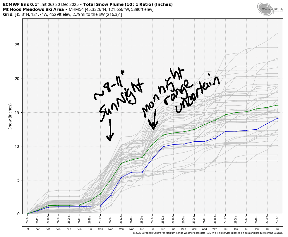
Hey skiers and snowboarders! Much calmer weather is in the Mt Hood snow forecast for the next five days or so. Cool temps linger, and we’ll add to the snowpack. The intraquartile range (25th to 75th percentile snowfall) calls for 12-18” through Christmas Day. Resorts are doing their best to clean up messes from the recent storms and get something open.
Some idea of what messes mean: Teacup Nordic reports 55 downed trees, and Highway 35 remains closed at the S-Curves (south of Cooper Spur and before Little John) and also at the 35/26 intersection due to landslides. Current snowpack: Meadows and T-Line picked up about 10-12” over the last 36 hours, so that’s what we’re working with.
Short term Mt Hood snow forecast
Saturday’s weather brings snow to the slopes. The snow level will be around 2000′ all day, and the freezing level will drop to 1000′ overnight. About 0.4” water equivalent (WE) is forecast during the day for 4-5” new snow. Overnight: dry weather with high clouds. Wind will be W 40 this morning, WSW 20-25 this afternoon, and SW 10-20 overnight.
Sunday starts dry and high overcast. Snowfall returns mid-afternoon and picks up overnight. The snow level will be 3000′ in the morning, 2000′ in the afternoon, and as low as 1500-2000′ overnight. About 0.1” WE is forecast in the afternoon followed by 0.8” overnight. Call that 9-10” new, relatively fluffy snow. Wind will be SW 10-20 in the morning, SW 15-30 in the afternoon, W 20 in the evening, and WSW 20-25 after midnight.
Extended Mt Hood Snow Forecast
A few flurries are forecast Monday morning before partly cloudy sky arrives midday. Light snow returns overnight. The snow level will be 1500′ early, 3000′ in the afternoon, and 2000′ overnight. Models call for 0.2” to 0.5” WE, so let’s say 2-5” new snow. Wind: WSW 20-25 in the morning, SW 30-45 in the afternoon and evening, and SW 20-25 overnight. A trace of snow is forecast on Tuesday (Christmas Eve).
Beyond that, model uncertainty increases. Additional snow is probably coming Christmas Day evening. Models hint at dry weather into the end of next week (or light precip in some models). Beyond the end of next week, there’s way too much uncertainty to hazard any sort of guess. Fingers crossed we’re sliding on the snow really soon!
Was that helpful? I knew it was! Guess what? All of this crucial work – from your personal wind and snow reports to the invaluable TATAS updates – is made possible by my relentless efforts. Maintaining this labor of love isn’t easy. Each daily forecast takes hours. Website hosting, weather model access, and back-end admin work takes time and money. That’s where you come in.
YOUR CONTRIBUTION MAKES A DIFFERENCE
- SUPPORT ACCURATE, HYPER-LOCAL WEATHER FORECASTING
- ENABLE ACCESS FOR ALL, EVEN THOSE WITH LESS MEANS
- SUPPORT A COOL HUMAN WHO WORKS HARD SO YOU CAN PLAY
Take a moment to click one of the buttons below. Donate $19.99 or more (how much does this forecast enhance your life?) and get the email in your inbox. Whether it’s a renewing subscription (auto-renew) or a one-time donation, every contribution makes a real difference. Help me keep this labor of love alive, so we can all continue playing, commuting, and living in the Gorge with peace of mind and the best weather forecasts possible. Thank you!


Hood River, Oregon 97031


GORGE WIND FORECAST
If you’re still seeing yesterday’s and it’s after 9am, try opening this in an incognito window
SHORT-TERM gorge wind forecast
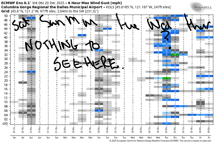
Hi friends! Not much at all happening in the next week or so. Active weather continues, but not as active as we’ve seen. This means two things: not enough power in the systems to drive winter westerlies, and not enough cold pool in the desert (I initially typed “cold poop”, btw) to contribute to strong easterlies.
Saturday starts with light onshore gradients: 30.04/30.03/30.00 and wind speeds under 10mph pretty much everywhere. The west side stays under 10mph today. Between Avery and Arlington, we’ll have a few hours of 18-22mph west wind (very gusty) midday before the entire Gorge goes calm. River flow over the last 24 hours was 187-225kcfs, river temp is 49.3F, and high temp forecast is 46F. Tons of debris remains in the river from recent flooding. Be very careful if you go out.
RIVER FLOW FOR SITES BETWEEN AVERY (EAST OF THE DALLES) AND RUFUS: CLICK HERE FOR JOHN DAY DAM FLOW.
RIVER FLOW FOR SITES BETWEEN STEVENSON AND DOUG’S BEACH (WEST OF THE DALLES): CLICK HERE FOR THE DALLES DAM FLOW

LONGER-TERM gorge wind forecast
Sunday starts with E 15mph at Stevenson and E 15-20mph at Iwash (Rooster) Rock. The wind drops by late morning, goes calm, and then turns westerly at 15mph between Iwash and Bonneville. Calm to the east, or nearly so. High temp: 43F. Monday starts with light/variable wind at Iwash and E 15mph at Stevenson. The wind goes calm by afternoon. High temp: 45F. Not much wind is forecast Tuesday or Wednesday. Beyond that, model uncertainty increases. If you find some wind, enjoy!
BARE BONES HOOD RIVER WEATHER FORECAST
Intermittent rain this morning. Cloudy this afternoon. Temps start in the mid 30s and rise to the mid 40s. Light westerlies. 100% chance of rainbows. Sunday will be dry in the morning and rainy in the afternoon. Temp start in the low 30s and rise to the low 40s. Light easterlies. 10% chance of rainbows. Monday will be cloudy then partly cloudy then cloudy. Temps start in the mid 30s and rise to the mid 40s. Light east wind early. Calm later. No rainbows.
TEMIRA’S AWESOME TRAVEL ADVISORY SERVICE
HYPERLOCAL WEATHER FORECAST FOR THE COLUMBIA GORGE
THE DALLES, HOOD RIVER, WHITE SALMON, TROUT LAKE, STEVENSON, CASCADE LOCKS, PARKDALE, ODELL, HUSUM, BZ, MILL A, WILLARD, GOLDENDALE, RUFUS, ARLINGTON, boardman

Good morning, neighbors! Gratitude this morning: calmer weather for at least the next week or so! Another morning gratitude: streets appear to be free of ¡CE so far today. While I can’t predict the return of La Migra, I most certainly can predict the weather. Let’s dive in!
Glenwood this morning
Early this morning, Glenwood’s temp was sitting at 35 degrees. The People Of Glenwood (a secret society that’s no longer secret because I’m talking about it) were knitting hats and mittens for the elders of town and baking cookies to deliver in the middle of the night to anyone over the age of 18. EVERYONE DESERVES COOKIES!
Announcements!
Other important news: all Hood River County lands and trails are currently closed to the public. I didn’t see a reason, but I’m going to assume trees have been falling down due to unstable soils and excessive wind/rain. Next: Dirty Fingers bike shop (Hood River) has a bicycle-based SantaCon this evening. Weather should be dry. Santas please arrive by 5pm. Parade rolls out at 5:30pm.
Today’s Gorge weather forecadst
Elsewhere in the Gorge, temps were generally in the mid 30s (low 40s along the Nch’i Wana west of Hood River). Snow level: somewhere between 2000′ and 2500′. We’ll see drizzle as far east as The Dalles (but not South Wasco!) into midday with drizzle as far east as Cascade Locks until sunset. From Wyeth eastward, we’ll have partly to mostly clear sky this afternoon. Yay, sun. Temps rise to the mid 40s (west), upper 40s (The Dalles), and near 50 (way out east). Wind: less than 10mph west of The Dalles, 15-20mph east of the Dalles midday, and calm or nearly so late afternoon on.
Sunday’s Gorge weather forecast
Overnight, minimal cloud cover contributes to dropping temps. Watch out for icy roads on Sunday morning anywhere exposed to patches of clear sky (although the road surface is still pretty warm, so maybe not?). With the freezing level around 1000′ early Sunday, any higher-elevation locations could also have icy roads. In an interesting twist, we’re also expecting some early-morning precipitation for South Wasco, Sherman, and Gilliam counties (especially the south parts) thanks to a system coming in from the south. This is likely to be either snow or freezing rain, but not a lot of it. End of that precip: midday. Next round of precip comes in from the west: 1pm for Cascade Locks, 4pm for Biggs, and 10pm for Arlington. That should be rain below 2000′. Above 2000-2500′ significant snowfall is likely. High temps; low to mid 40s everywhere in the lowlands.
Extended Gorge weather forecast
Light rain early Monday morning gives way to dry, partly cloudy weather after 10am. Exception: areas west of Viento will see drizzle all day, all night, and into Tuesday morning. Clouds return west of Mosier in the afternoon, but areas to the east stay mostly clear. Temps start in the mid 30s and rise to the mid 40s. Wind will be E 15mph near Stevenson (and only Stevenson) early and calm in the afternoon.
Mostly dry weather is forecast Tuesday will the freezing level at 2000′-3000′. Christmas Day: probably dry. Next significant system is late on Christmas Day. If you want a white Christmas, vote for that system to come in around 4am instead of 4pm. Okay. Let’s leave it there for now. Safe travels. -TATAS
HEY! DON’T STOP READING! Is this community-focused forecast helpful to you? It sure is! It takes me a couple hours a day to write. Please join your friends and neighbors in contributing to keep it going. Venmo: @thegorgeismygym PayPal: twomirrors@gmail.com USPS: Temira / PO Box 841 / Hood River, Oregon 97031 You can test out the forecast subscription for a few days for free by signing up below. Easy! Do it!
JONES BEACH, SAUVIE ISLAND, & COAST FORECAST
ON WINTER VACATION UNLESS DESPERATELY NEEDED.
