

MT HOOD SNOW FORECAST

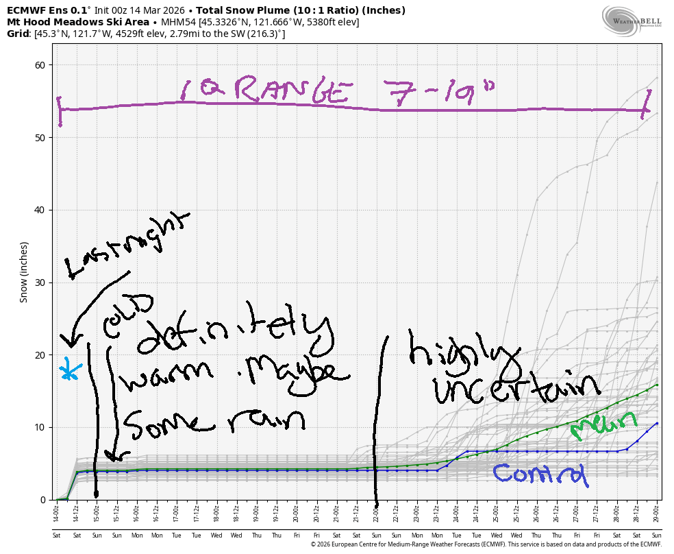
Hey skiers and snowboarders! Good news – we picked up several feet of snow this week. Bad news – we picked up several inches of rain on top of that snow. As the storm is tapering down this morning, we’ve picked up a couple inches of new atop the saturated snowpack, but that won’t be enough to make a huge difference in surface conditions. Maybe that’s okay – we’re headed into a very warm week of spring skiing, and soaked snow transitions to granular faster than dry snow!
Updates this morning include: Meadows with another “high winds will affect lift ops” warning. Teacup can’t groom due to lakes and puddles. Timberline has “WEATHER PERMITTING” in all caps. Meadows Nordic is grooming without significant problems. Forecast today is for the wind to drop off around 9am and allow some lifts to turn, but it will remain breezy today. The snow level was around 3000′ early and will fall as low as 1500′ today, but the snowfall is pretty much done. We’ll see sunshine on the slopes today. Wind will be NW 40 (shutdown territory) early, NW 25-30 mid-morning (some lifts should turn in that), NW 20-25 in the evening, and variable to 10 overnight.
Short term Mt Hood snow forecast
Sunday looks high overcast (stellar sunrise alert!) most of the day with a chance of light drizzle late afternoon. Just a trace of rain is forecast. The snow level will be around 1000′ early, 7500′ in the afternoon, and 11,000′ after midnight. Temps at 5000′ max out in the low 40s. Wind will e variable to 10 early, W 20 in the afternoon, and W 35 overnight.
Monday will be cloudy in the morning and sunny in the afternoon. The free air freezing level (FAF) will be over 10,000′ all day. Wind will be W 35 in the morning, W 30 in the afternoon, SW 25-35 in the evening, and WSW 35-40 after midnight.
Extended Mt Hood Snow Forecast
Tuesday will be partly cloudy and warm with temps maxing out near 50 degrees. Freezing level: above 10,000′. Wind: WSW or SW 30-35 all day. Similar weather, but cloudier, is forecast on Wednesday.
Uncertainty increases as we head into the latter half of next week, but the weather will almost certainly remain above freezing through next weekend. No significant precipitation events are forecast at this time, although an atmospheric river will be hammering BC for much of the week. Have fun on the slopes, everyone!
Was that helpful? I knew it was! Guess what? All of this crucial work – from your personal wind and snow reports to the invaluable TATAS updates – is made possible by my relentless efforts. Maintaining this labor of love isn’t easy. Each daily forecast takes hours. Website hosting, weather model access, and back-end admin work takes time and money. That’s where you come in.
YOUR CONTRIBUTION MAKES A DIFFERENCE
- SUPPORT ACCURATE, HYPER-LOCAL WEATHER FORECASTING
- ENABLE ACCESS FOR ALL, EVEN THOSE WITH LESS MEANS
- SUPPORT A COOL HUMAN WHO WORKS HARD SO YOU CAN PLAY
Take a moment to click one of the buttons below. Donate $19.99 or more (how much does this forecast enhance your life?) and get the email in your inbox. Whether it’s a renewing subscription (auto-renew) or a one-time donation, every contribution makes a real difference. Help me keep this labor of love alive, so we can all continue playing, commuting, and living in the Gorge with peace of mind and the best weather forecasts possible. Thank you!


Hood River, Oregon 97031


GORGE WIND FORECAST
If you’re still seeing yesterday’s and it’s after 9am, try opening this in an incognito window
SHORT-TERM gorge wind forecast
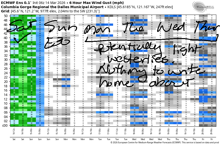
Hi friends! Nice to share some time on the water with you yesterday! Models have backed off on their expectations for today, but it still looks windy. We’ll switch to easterlies tomorrow (Sunday) and then ridging takes over and leaves us with (probably) light wind for much of next week. But hey, it’ll be warm!
Saturday started with pressures of 30.09/29.92/29.88 for gradients of 0.17 (wow!) and 0.04. Prior to dawn the sweet spots were Viento (31) and The Wall (29). Models suggest quickly dropping gradients this morning especially west of The Dalles. Still, we should see a period of 21-24 at the Hatch prior to the wind falling to 17-20mph mid-morning. From Lyle to Rufus, you’ll find 26-29mph much of the day. Arlington is likely to join at 26-29mph late morning or early afternoon. The wind starts dropping mid-afternoon and ends with 10-13mph on the west side and 13-16mph out east. River flow over the last 24 hours was 197-217kcfs, and river temp is 45.5F. High temp forecast is 47F in Hood River and 51F out east with increasingly sunny sky.
RIVER FLOW FOR SITES BETWEEN AVERY (EAST OF THE DALLES) AND RUFUS: CLICK HERE FOR JOHN DAY DAM FLOW.
RIVER FLOW FOR SITES BETWEEN STEVENSON AND DOUG’S BEACH (WEST OF THE DALLES): CLICK HERE FOR THE DALLES DAM FLOW

LONGER-TERM gorge wind forecast
Sunday sees cool air in the desert combine with warm air on the west side for offshore gradients and east wind. Iwash (Rooster) Rock starts the day with 30-35mph and Stevenson starts with 20-25mph. Midday brings 25-30mph at Stevenson and holds at Iwash. After 2pm, the wind drops off a cliff: 15mph at Stevenson and 15-20mph at Iwash. High temp: 50F with cloudy sky.
Monday brings early westerlies at 15-18mph from Viento to the Hatch and also near Rufus. The wind holds for a few hours and then drops below 10mph in the afternoon. High temp: 66F with increasing sunshine. Similarly light, similarly warm, and probably cloudy weather is forecast for Tuesday and Wednesday. Beyond that, uncertainty increases. Have a fun day on the river today – watch out for debris in the water from recent heavy rain. Keep an eye on your buddies!

BARE BONES HOOD RIVER WEATHER FORECAST
Partly cloudy this morning. Mostly sunny later. Temps start in the mid 40s and rise to the upper 40s. Moderately strong westerlies becoming light later. No rainbows. Sunday will be cloudy. Temps start in the low-mid 30s and rise to 50. Light easterlies. No rainbows. Slight chance of drizzle in the evening. Monday will be partly cloudy then clear. Temp start in the upper 30s and rise to the mid 60s (WARM). Moderate westerlies becoming light. No rainbows.
TEMIRA’S AWESOME TRAVEL ADVISORY SERVICE
HYPERLOCAL WEATHER FORECAST FOR THE COLUMBIA GORGE
THE DALLES, HOOD RIVER, WHITE SALMON, TROUT LAKE, STEVENSON, CASCADE LOCKS, PARKDALE, ODELL, HUSUM, BZ, MILL A, WILLARD, GOLDENDALE, RUFUS, ARLINGTON, boardman

Good morning, neighbors! Not much to see here… just another day in the warmest winter on record. This upcoming week will add to the momentum of the warmth as we see temps climb to 65-70F.
Glenwood this morning
Looking around the Gorge this morning, we see … puddles left over from the recent Pineapple Express. Glenwood started the day at 39F, but it’s dropped to 36F with the arrival of the cold front. Rest of today across the Gorge: breezy, increasingly sunny, and 47-52F. (Can you tell I’m in a hurry this morning?)
Sunday’s Gorge weather forecast
Sunday will be mostly cloudy. After a 30 (up high) to 35 (down low) degree start, temps climb to 50F. We’ll see easterlies at 30mph in the usual spots (Stevenson, Cock Rock) in the morning with 15-20mph in the afternoon. Rest of us: not very windy at all.
Extended Gorge weather forecast
A massive pattern shift is penciled in for Monday as a ridge of high pressure takes over the western US. After a partly high overcast start (pretty sunrise), we finish up mostly clear. High temps rise to 64-67F!!! Where are my flip flops? Where are my tank tops? We’ll have light westerlies along with the sun and warmth. Tuesday and Wednesday look rather more cloudy and equally warm (mid 60s) with 70F possible out near Pasco. We’re not expecting much wind as temp gradients equalize between the metro area and the Gorge.
Looking deeper into the future… I actually, tactfully, considered planting a tomato plant outside – I’m not seeing much evidence of any sort of frosty weather. This is batshit. We’ll delve more into that tomorrow or Monday. Safe travels. -TATAS
HEY! DON’T STOP READING! Is this community-focused forecast helpful to you? It sure is! It takes me a couple hours a day to write. Please join your friends and neighbors in contributing to keep it going. Venmo: @thegorgeismygym PayPal: twomirrors@gmail.com USPS: Temira / PO Box 841 / Hood River, Oregon 97031 You can test out the forecast subscription for a few days for free by signing up below. Easy! Do it!
JONES BEACH, SAUVIE ISLAND, & COAST FORECAST
ON WINTER VACATION UNLESS DESPERATELY NEEDED.

Leave a Reply