

MT HOOD SNOW FORECAST

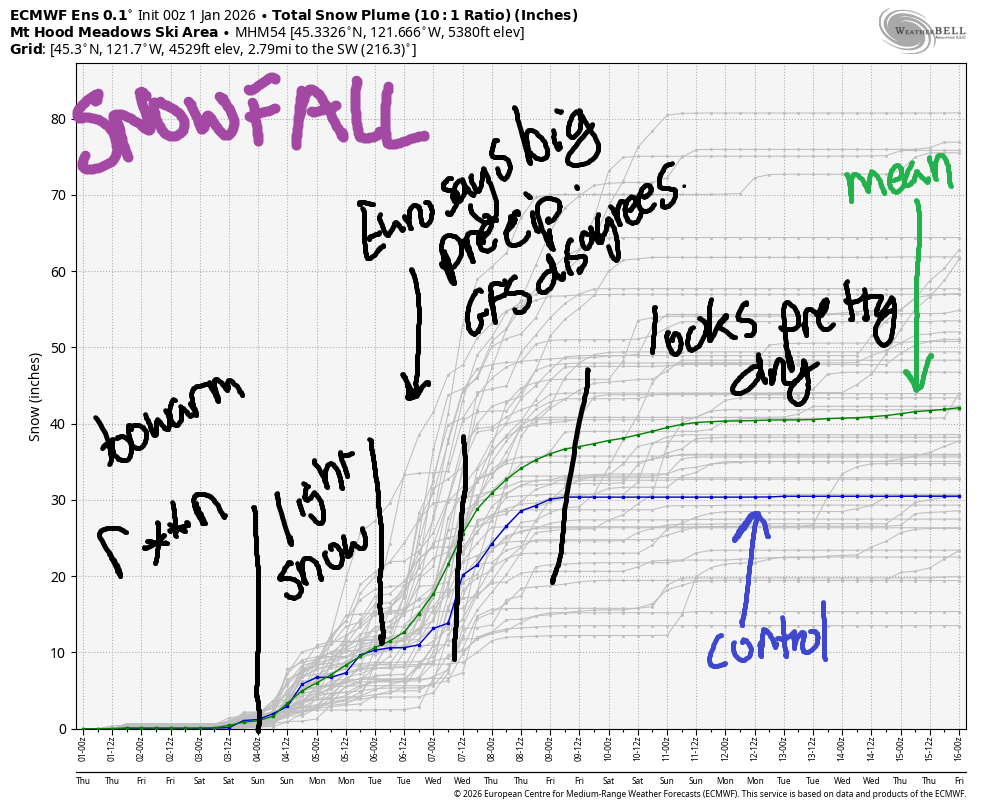
Hey skiers and snowboarders! Happy new year to all of you! Mother Nature decided to start the new year off with the unmentionable precipitation (r**n), and that will continue for a few days. In the good news department, temps cool off late Sunday or early Monday and leave us in a cooler, snowy pattern much of the time through next Friday. That said, there are concerning signs of a warm/wet period next Wednesday from the ECMWF, but no sign of that in the GFS. We’ll keep watching this closely!
Beyond next Friday, model uncertainty is too high to make predictions. Looking at the intraquartile range (25th-75th percentile) for snowfall through next Friday, we have the Euro calling for 25-47”. That’s a massive improvement over yesterday’s forecast. Let’s cross our fingers this holds!
Short term Mt Hood snow forecast
Looking at Thursday, we’ll have light to moderate rain on Mt Hood and, notably, freezing rain at the lower elevations in the Gorge and on the highways near Mt Hood. Do be prepared for tricky driving conditions. The snow level will be 7000′ early, 8000′ in the afternoon, and 7000′ after midnight. Daytime rain will be 0.2” to 0.3”. Overnight, we’re expecting 0.5” to 0.6”. Wind will be S 10-20 this morning, SW 15-25 this afternoon, and SW 20-40 overnight.
Light rain continues on Friday and tapers off overnight. The snow level will be 7000′ in the morning and 6000′ from the afternoon on. Down low: freezing rain continues for some areas, particularly Weird Weather Flats and Highway 35 from the Hood River side, and potentially near Govy and from there to Meadows. We’re expecting 0.2” to 0.3” rain on the slopes in the morning with just a trace after noon. Wind: SW 20-40 in the morning, WSW 30-40 midday, SW 15-30 in the evening, and SW 10-15 after midnight.
Extended Mt Hood Snow Forecast
Moderate rain Saturday morning gives way to a short break then light rain overnight. The snow level will be around 6500′ for the 24 hour period. Rain totals: 0.3” during the day and 0.1” overnight. Wind: SW 10-15 in the morning, SSW 20-40 in the afternoon, and SW 30-55 after midnight.
Sunday looks dry during the day with a trace of wet snow or light mixed precip overnight. Light snow is forecast Monday and Tuesday. Models disagree on what will happen on Wednesday. The euro drags in tropical moisture and mixes that with colder air coming from the northwest. This scenario could result in a big snow dump for Mt. Hood. The GFS, on the other had, just brings in light to moderate snowfall. Beyond that, models agree on cooler weather to end next week followed by higher levels of uncertainty. So… generally speaking, we’ll have rain through Saturday followed by cooling weather and some sort of snowfall for much of next week. Fingers crossed the improved intraquartile range plays out. A big dump would be awesome! Happy new year, everyone!
Was that helpful? I knew it was! Guess what? All of this crucial work – from your personal wind and snow reports to the invaluable TATAS updates – is made possible by my relentless efforts. Maintaining this labor of love isn’t easy. Each daily forecast takes hours. Website hosting, weather model access, and back-end admin work takes time and money. That’s where you come in.
YOUR CONTRIBUTION MAKES A DIFFERENCE
- SUPPORT ACCURATE, HYPER-LOCAL WEATHER FORECASTING
- ENABLE ACCESS FOR ALL, EVEN THOSE WITH LESS MEANS
- SUPPORT A COOL HUMAN WHO WORKS HARD SO YOU CAN PLAY
Take a moment to click one of the buttons below. Donate $19.99 or more (how much does this forecast enhance your life?) and get the email in your inbox. Whether it’s a renewing subscription (auto-renew) or a one-time donation, every contribution makes a real difference. Help me keep this labor of love alive, so we can all continue playing, commuting, and living in the Gorge with peace of mind and the best weather forecasts possible. Thank you!


Hood River, Oregon 97031


GORGE WIND FORECAST
If you’re still seeing yesterday’s and it’s after 9am, try opening this in an incognito window
SHORT-TERM gorge wind forecast
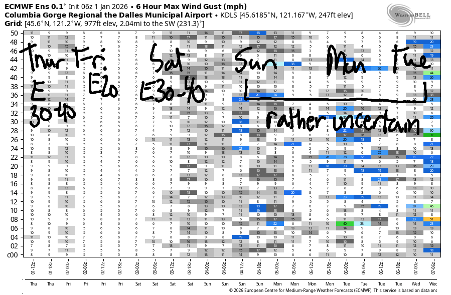
Hi friends1 Easterlies continue for at least the next few days. Accompanying the east wind: intermittent rain and temps in the mid 30s today (Thursday) and low 40s the next couple of days. Warmer temps are forecast on Sunday and Monday, but less wind is forecast too.
New Year’s Day started off with strong easterlies and these pressures: 29.85/30.01/30.03. East wind at the start of the day was 40mph at Iwash (Rooster) Rock, 30mph at Stevenson, and 22mph at Viento. The wind will hold all day long. River flow over the last 24 hours was 175-218kcfs, river temp is 44.2F, and high temp forecast is 36F with rain in Stevenson and ice in Hood River.
RIVER FLOW FOR SITES BETWEEN AVERY (EAST OF THE DALLES) AND RUFUS: CLICK HERE FOR JOHN DAY DAM FLOW.
RIVER FLOW FOR SITES BETWEEN STEVENSON AND DOUG’S BEACH (WEST OF THE DALLES): CLICK HERE FOR THE DALLES DAM FLOW

LONGER-TERM gorge wind forecast
Friday starts with easterlies at 20mph at both Stevenson and Iwash. The wind drops below 10mph midday and builds again into the evening as a low pressure system approaches offshore. The day ends with E 15-20mph at Stevenson and perhaps 10mph at Iwash. High temp: low 40s with drizzle much of the day.
For the weekend, we’ll have rain and stronger easterlies for Saturday. The day starts with 30-35mph at Iwash and 20-25mph at Stevenson. The wind spikes mid-morning and drops to 15-20mph in the afternoon before building again into the evening in response to a low pressure system offshore. Lighter easterlies, probably below 20mph, are forecast on Sunday. It’s possible we could see westerlies return (too light, probably, for wind sports) late in the day Monday. That’s all I’ve got for you today. Happy New Year!!!
BARE BONES HOOD RIVER WEATHER FORECAST
Light freezing rain today potentially switching to rain down low and potentially staying ice in higher areas. Temps start in the low 30s and rise to the low-mid 30s. Light easterlies. No rainbows. Friday will start with light ice up high and light rain down low. Temps start in the low 30s and rise to the upper 30s (NWS says 45F, but I’m not buying that). Light easterlies. 1% chance of rainbows. Saturday will be rainy. Temps start in the upper 30s and rise to the low 40s. Light easterlies. 8% chance of rainbows.
TEMIRA’S AWESOME TRAVEL ADVISORY SERVICE
HYPERLOCAL WEATHER FORECAST FOR THE COLUMBIA GORGE
THE DALLES, HOOD RIVER, WHITE SALMON, TROUT LAKE, STEVENSON, CASCADE LOCKS, PARKDALE, ODELL, HUSUM, BZ, MILL A, WILLARD, GOLDENDALE, RUFUS, ARLINGTON, boardman
Good morning, neighbors! The Gorge is finally behaving like its prickly self – freezing rain is falling in many areas this morning. Happy new year – you get ice! For some of us down low, all we’ll see is rain. For others in colder areas – Parkdale, Middle Mountain, Stabler, Husum, Trout Lake, south Wasco, the icing could continue into Friday. Beyond that, we just have regular old boring weather. Next up in weather excitement is the potential for heavy rain (ECMWF) or regular old rain (GFS) sometime around next Wednesday.
Glenwood this morning
Let’s start 2026 by checking in with Glenwood. It’s 27 degrees, and the radar suggests light freezing rain. Everyone in Glenwood has taken the advice of P from high prairie and JH in Hood River: “it’s a good day for baking”. TATAS agrees. TATAS is going to dig out some chicken bones and make stock which TATAS will then put outside to cool. You should do the same. A Chicken Stock Advisory is officially posted.
Today’s Gorge weather forecast
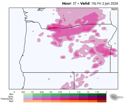
For the rest of us today: conditions on 84 right along the river should stay rain as far east as John Day Dam, but east of there, freezing rain is likely. SR-14, thanks to those higher-elevation spots, is trickier. You could find some ice up high. Ditto for 97 and 35 – they’re both going to get some freezing rain. The system causing this is coming from the south, so South Wasco, Sherman, and Gilliam Counties will also see light freezing rain. Heaviest accumulations: west side of Odell and Hood River if temps don’t warm; Underwood, Stabler; Willard, elevated areas of Stevenson; Snowden, Trout Lake, BZ, Husum. Call that 0.1” to 0.25” icing if temps don’t warm.
This is really a tricky setup to predict warming. Usually we see freezing rain thanks to a cold pool related to Arctic air dropping south from Canada. This time, it’s just leftover cold from radiational cooling. Solar heating (the OG of heat) will do its work today, but it’s hard to say if we’ll all climb above 32F. Overnight, we’re likely to lose a few degrees, so those previously mentioned areas could pick up more ice tonight when heavier precip arrives. Wind today: E 40mph near Iwash (pen*s) Rock, 30mph near Stevenson, and 20mph near Viento with lighter wind elsewhere. Temps max out in the mid 30s near the river. Last thing about today: moderately heavy rain falls west of Viento from 1pm on through the night. That’ll make for one of those standard-issue unpleasantly splashy Gorge drives.
Friday’s Gorge weather forecast
Friday sees intermittent light drizzle as far east as Rowena all day long and into the evening. The drizzle extends east to the Tri-Cities after 4pm. As I said before, folks in the coldest areas are likely to be below freezing Friday morning and to pick up some ice. Most affected by this system from the west: anyone west of Rowena. While the NWS forecast suggests temps will rise to the mid 40s in the lowlands, that seems overly optimistic. That said, moderately strong WSW wind aloft should scour out the remaining cold air by Friday afternoon. We’ll be left with a freezing level around 6000′. River-level wind on Friday will be 20mph near Dick Rock and Stevenson to start the day and less later.
Extended Gorge weather forecast
Plain old rain is forecast on Saturday morning as far east as Hermiston. A short break late afternoon gives way to more rain overnight. Morning temps: upper 30s. Afternoon: mid 40s. Snow level: 6000′. I’m crying. Iwash (wanker) wind: 30-35mph in the morning, 40mph midday, and 25mph in the evening. Stevenson: 20-25mph. Sunday will likely be dry and 50ish degrees. Okay. My hands are tired from typing all those words. Be careful on those slippery roads over the next day or two. Safe travels. -TATAS
HEY! DON’T STOP READING! Is this community-focused forecast helpful to you? It sure is! It takes me a couple hours a day to write. Please join your friends and neighbors in contributing to keep it going. Venmo: @thegorgeismygym PayPal: twomirrors@gmail.com USPS: Temira / PO Box 841 / Hood River, Oregon 97031 You can test out the forecast subscription for a few days for free by signing up below. Easy! Do it!
JONES BEACH, SAUVIE ISLAND, & COAST FORECAST
ON WINTER VACATION UNLESS DESPERATELY NEEDED.
