

MT HOOD SNOW WEATHER FORECAST
Hey skiers and snowboarders! It’s clear and crisp and spectacular again on the slopes today, and that’s the story for the next couple of days. Snow returns on Thursday and Friday, dry weather is likely Saturday, and then we slide into a questionable weather system on Sunday. If you’re going up the next few days, bundle up – temps were right around 10F at the base areas this morning with single digits up high and 6-15F in the Nordic lowlands. Wax blue for Nordic, and consider cleaning and waxing your alpine gear for better results as temps turn very cold and the humidity drops over the next few days.
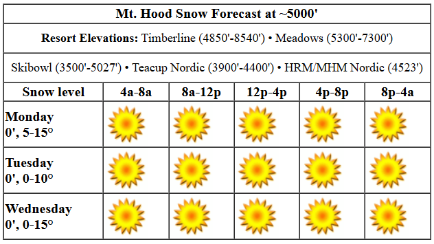
Monday just looks glorious! Sunshine all day with the free air freezing level at 0′. Snow conditions are packed powder and hardpack on the groom. It’s possible we could see a few easterly orographic snow flurries today, but it’s far from guaranteed. Temps today will be in the low to mid double digits all day, and they’ll plummet as soon as the sun sets. Wind? E 10-15 all day and E 25 after midnight.
Tuesday looks cold AF (for here, anyway) and breezy. Expect temps in the single digits all day. Add in east wind at 25mph in the morning and 15-20mph in the afternoon for very low wind chill. That’s probably not enough east wind to cause chaos at Timberline, but check and make sure all the lifts you want are running before you head up. Wednesday looks a lot like Tuesday, but the wind will turn SSE in the afternoon and feel like less on the slopes. Temps will be just a few degrees warmer in the afternoon, perhaps in the low teens.
A transition out of cold/super-dry begins on Thursday. A system sweeps in from the SW and slides inland south of Mt. Hood. Models still don’t have a handle on how much snow we’ll see from this. As of this morning, the suggested 0.1” water equivalent (WE) during the day for an inch of new followed by 0.3” to 0.5” WE overnight for 4-7” of increasingly dense snow. While the snow level will be 0′ for the period (yeah, it’ll probably snow at your house too), temps will rise from -12C (20F) to -2C (28F) at 5000′ as this system swings through.
A few more inches of snow snow are possible Friday. Saturday looks dry. Models suggest a much wetter system for Sunday into Monday. This one, unfortunately, may be warm enough to turn the p-type from snow to snain or rain. We’ll keep a close eye on this. Given today’s conditions and all the “stuff” happening between now and Sunday, there’s a lot that could change between now and then. IN the meantime… I’ll see you on the snow. Have fun, and stay warm!
Liking this forecast?
Was that helpful? I knew it was! Guess what? All of this crucial work – from your personal wind and snow reports to the invaluable TATAS updates – is made possible by my relentless efforts. Maintaining this labor of love isn’t easy. Each daily forecast takes hours. Website hosting, weather model access, and back-end admin work takes time and money. That’s where you come in.
YOUR CONTRIBUTION MAKES A DIFFERENCE
- SUPPORT ACCURATE, HYPER-LOCAL WEATHER FORECASTING
- ENABLE ACCESS FOR ALL, EVEN THOSE WITH LESS MEANS
- SUPPORT A COOL HUMAN WHO WORKS HARD SO YOU CAN PLAY
Take a moment to click one of the buttons below. Donate $19.99 or more (how much does this forecast enhance your life?) and get the email in your inbox. Whether it’s a renewing subscription (auto-renew) or a one-time donation, every contribution makes a real difference. Help me keep this labor of love alive, so we can all continue playing, commuting, and living in the Gorge with peace of mind and the best weather forecasts possible. Thank you!


Hood River, Oregon 97031


GORGE WIND FORECAST

Hi friends! No! It’s too cold! Don’t do it! Temps stay sub-freezing all the way through next Monday, probably, with a tiny chance of a period of west wind on Friday as a low swings through. For Monday, we’ll see easterlies build to 25mph near Stevenson and Iwash (Rooster) Rock by early afternoon. The wind holds overnight. River flow over the last 24 hours was 100-168kcfs, river temp is 39.02F, and high temp forecast is 35F.
Tuesday starts with easterlies at 40mph at Iwash and 25mph at Stevenson. Both locations level out at 35mph late morning and hold into the night. High temp: 31F and sunny. Wednesday brings easterlies at 50mph at Iwash, 35mph at Stevenson, and 10-20mph east of Viento depending on location. High temp: 31F and sunny. Thursday’s wind: 60mph at Iwash. Silly people, no. It’ll still be too cold. Don’t risk it!
BARE BONES HOOD RIVER WEATHER FORECAST
Clouds this morning give way to clear sky this afternoon. Temps start in the low-mid 30s and don’t rise much. Light to moderate easterlies. No rainbows. Tuesday will be clear with a chance of partial Nothing early with clear sky later. Temps start in the low teens and rise to the low 30s. Light to moderate easterlies. No rainbows. Wednesday will be partly Nothing then clear. Temps start in the low double digits and rise to the low 30s. Light to moderate easterlies. No rainbows.
TEMIRA’S AWESOME TRAVEL ADVISORY SERVICE (HYPERLOCAL GORGE WEATHER FORECAST)
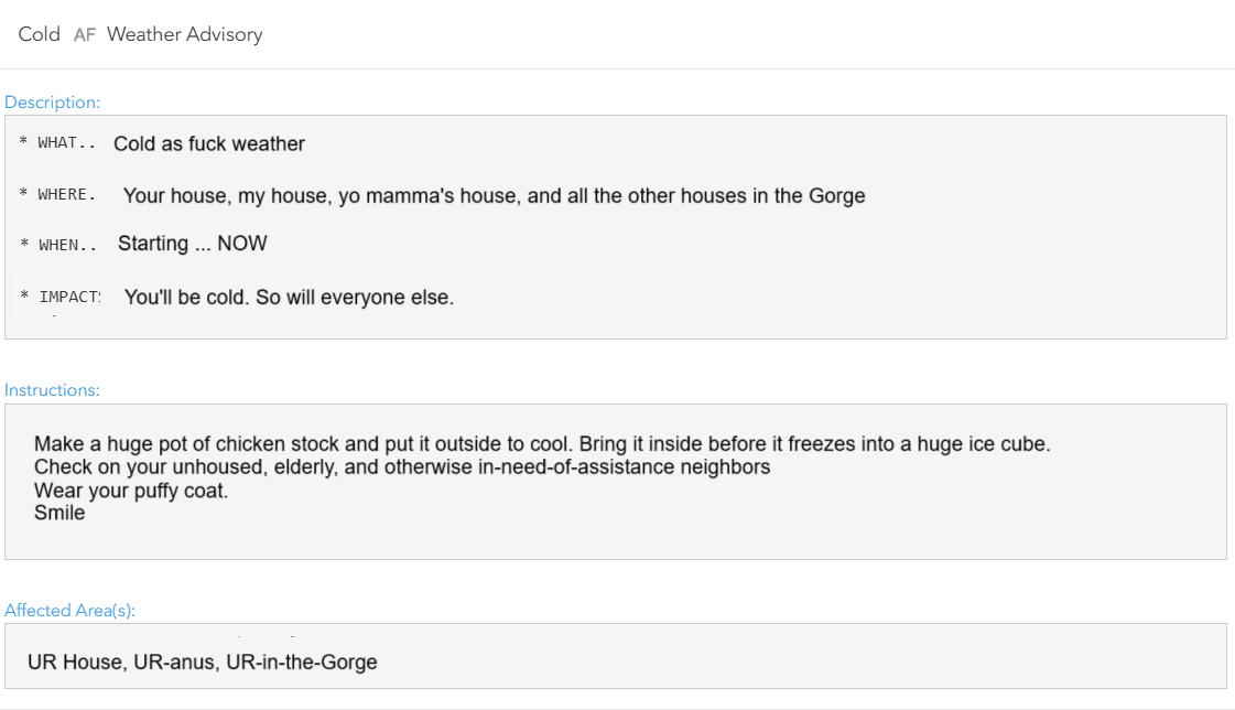
Good morning, neighbors! It’s cloudy out there this morning for many of us, but don’t you worry. Sun is coming. But so are bitterly cold temps. Chicken Stock Warning has been issued alongside NWS’ self-explanatory “Cold Weather Warning”. Temps will be in the teens overnight the next few nights. On Thursday, the fun begins with light snowfall. Probably. It’s unlikely the following few days will be able to muster up the gumption to drive the authoritarian regime away. Oops, I meant the next few days wouldn’t be able to muster up the gumption to drive sub-freezing temps out of the Gorge. Activist slip. Sorry, not sorry. This leaves us primed for freezing rain on Sunday unless something changes dramatically in the models between now and then.
glenwood!
Let’s check in with Glenwood. It’s 27 degrees with a dewpoint of 21 degrees to start the day. It must be cloudy in Glenwood, because Meadows Nordic was 6 degrees this morning! That 6 degree reading does not bode well for Glenwood when the sky is clear the next couple of nights. Folks, protect your pipes (and that’s not just for Glenwood). On to the TATAS Executive Order Of The Day: universal background checks for firearms, universal requirement to be 21 to buy a handgun, a complete ban on bump stocks and assault weapons (with a $5000 buyback incentive), and universal red flag laws for folks convicted of interpersonal violence. Signed with a really, really big and bold black marker, but not the one that I own that leaves a long-lasting intoxicating scent.
monday
Let’s look at today. It’s Monday, the start of the traditional work week (which should be 4 days, not 5). And since it’s winter and traditionally gray and cloudy, that’s how we start. A few flurries east of The Dalles and in SW/Sherm this morning give way to clear sky in the east and clouds in the west this afternoon. Easterlies rise to 25mph near Stevenson and Iwash (schlong) Rock and 10mph east of Hood River. Arctic air sneaks in from the NE tonight.
tuesday & wednesday
That leaves us cold AF (hence the NWS “Cold weather advisory”) to start Tuesday. Single digits are totally possible in the outlying areas with teens other places. Why? Because the air mass will be -14C which is a temp that happens when 14 Canadians cross the boarder at once. While it could get cold enough for the dewpoint to meet the temp and make Nothing, many places will start clear, and the day will finish up sunny. Easterlies hold at 35-40mph near Iwash (dick) Rock and 25-35mph near Stevenson. East of Hood River, you’ll find easterlies at 5-10mph. In the hills, E 25mph. Be careful out there – wind chill temps will be bitterly cold. Hypothermia and frostbite are in the cards. Did you have those two terms on your bingo card alongside “billionaire accessing my Social Security data”? If so, congratulations! You don’t win anything! Wednesday looks almost identical to Tuesday: single digits and teens to start, nuking east wind in the usual spots… easterlies pick up to 15-20mph near The Dalles with 15mph in SW, where a few orographic snow flurries are possible but far from promised.
Oh yeah… temps max out around 31F in the lowlands both Tuesday and Wednesday.
thursday, friday, & saturday
On to Thursday. A low pressure system approaches the coast south of Astoria. Bingo! That’s where you want it for snow in the metro area and the lowlands. Most of the ensembles have it a bit too far south for the biggest of big messes, so if someone has the power to nudge it to, say, Oceanside or Manzanita, that’d be great. Anyway, we’re likely to see a bit of snow from this one – higher quantities will be to the west and south with less to the north and east. How much, you ask? A trace to 3” for the Gorge unless something changes. Time frame: mid-morning on, or maybe early afternoon on. Definitely avoid the Valley of Willies on Thursday: they’ll be picking up freezing rain (south) and snow (north). Snow continues on Friday for the Gorge. Saturday: probably dry.
extended forecast (trigger warning: contains messy weather)
Most ensemble members defuse the low causing this mess before it crosses the Cascades. Why do we care? First, because we are caring people. But weatherwise we care because this means we here in the Gorge stay below freezing. Not only does the low fall apart, but its passage south of us allows cold arctic air to surge back into the Gorge. This primes us for the next couple of systems: a weak-ish one Saturday evening and a much stronger one Sunday. Unless something amazing changes and that cold air gets scoured out, the weekend is likely to bring us a one-two-three punch of snow, sleet, then freezing rain. Neat. Need to get your ass outta here? Do it before Saturday afternoon.
It’s worth noting that precip amounts west of Hood River are pretty darn high (at least an inch, maybe two) for this Saturday-Sunday system. If it does come in as freezing precip, be prepared for power outages, road closures, and all the other stuff that comes along with a big winter storm. Last thing: strong easterlies will still be in place on Saturday, which means there’s a chance for the elusive Blizzard Warning that day.
When will we warm up above freezing? Models are hinting at Monday, but no promises. Safe travels. -TATAS
HEY! DON’T STOP READING! Is this community-focused forecast helpful to you? It sure is! It takes me a couple hours a day to write. Please join your friends and neighbors in contributing to keep it going. Venmo: @thegorgeismygym PayPal: twomirrors@gmail.com USPS: Temira / PO Box 841 / Hood River, Oregon 97031 You can test out the forecast subscription for a few days for free by clicking this link: https://subscribepage.io/YhevGc
