

GORGE WIND FORECAST
today’s gorge wind forecast
Hi friends! Active weather today settles down tomorrow and leaves us sitting pretty with a favorable setup for strong westerlies in the Gorge wind forecast for Tuesday and Wednesday. Westerlies of some sort stick around all next week. Taking a look at the ensembles for Victoria Day weekend, we see… WIND! Ensembles are particularly optimistic about Sunday, and they’re solid for both Saturday and Monday. Canadian and considering? Know that I, at least, welcome you in solidarity, with boundless kindness and joy for the fun you’ll have on the river. I’d offer to share Cheetos with you, but you’ve definitely got us beat with your Cheezies!
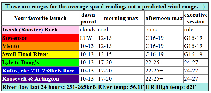
Let’s take a look at Monday, shall we? Hood River started out cloudy, and clouds of some sort stick around thanks to a low headed for the central coast. As that low moves inland this afternoon, high pressure builds offshore and gradients increase inland. While there are too many moving bits and pieces for an ideal setup, it’s not bad. Wind speeds at Dawn Patrol time were generally under 10mph with pressures of 29.75/29.72/29.71. By late morning, models build the westerlies to 12-15 (cloudy and gusty) from Stevenson to Hood River with 17-20 from Mosier to Arlington. For the afternoon, we’ll see a slow build to gusty 16-19 from Stevenson to Swell as clouds burn back. Between Mosier (or maybe Lyle – depends on the cloud line) and Rufus, westerlies slowly build to 24-27. East of Rufus: gusty 18-22. Today’s strongest winds will likely be in the Lyle-Avery zone. River flow over the last 24 hours was 221-265kcfs, river temp is 56.1F, and high temp forecast is 62F for Hood River and 63F for Arlington.

tomorrow’s gorge wind forecast
Offshore high pressure totally dominates the eastern Pacific on Tuesday, wind aloft assists with NW 30mph, and a weak, but helpful thermal gradient sets up in the afternoon. All good things, my friends! With low clouds sticking around much of the day on the west side, you’ll find the strongest wind between Lyle and Rufus. Dawn Patrol looks like 20-24 from Viento to Threemile with less at very cloudy Stevenson. Hold out for the afternoon if you’re seeking the strong/steady combo. By noon, we’ll have gusty 21-24 from Stevenson to Hood River (maybe less in Hood River and Swell), 25-28 from Lyle to Rufus, and 21-24 from Arlington to Boardman. Mid-afternoon is where it’s at: very gusty, up/down 20-26 from Stevenson to Mosier as the clouds start to burn back, 28-32 from Lyle to Arlington, and 25-28 from Threemile to Boardman. High temp: 63F for Hood River with 66F at Arlington. Keep in mind that the wind speeds are for the iWind/iKite sensors, and those eastern Gorge sensors read high compared to Swell. 24 at Swell is about the same as 30 at Arlington and The Wall.
extended Gorge wind forecast
Wednesday looks just as good as Tuesday. As a matter of fact, models have been bouncing around back and forth on which is the “better” (in my book, stronger) day. Tuesday Dawn Patrol looks like 11-14 from Stevenson to The Dalles with 24-27 from Avery to Boardman – models actually have low clouds almost as far east as Arlington! So, have some patience for the strongest conditions, and go before 2pm if you’re seeking lesser wind. We’ll see a slow build to gusty 21-25 between Stevenson and Mosier, 28-32 from Lyle to Arlington, and 26-29 at Threemile. High temp: 64F for Hod River and 66F for Arlington.
Thursday looks a bit lighter as a system approaches and disrupts our relationship with the offshore high. For now, let’s call Thursday 23-26 from Mosier to Rufus and adjust as needed. Friday looks like the lightest of the bunch; ensembles take the wind down to the 18-22 range. For the Canadian holiday weekend, as I mentioned before, models are very happy with the possibilities, and I hope some of you will come hang with us and feel the love we have for you. All right, people. That’s it for today. Have an awesome day on the Nch’i Wana!
Was that helpful? I knew it was! Guess what? All of this crucial work – from your personal wind and snow reports to the invaluable TATAS updates – is made possible by my relentless efforts. Maintaining this labor of love isn’t easy. Each daily forecast takes hours. Website hosting, weather model access, and back-end admin work takes time and money. That’s where you come in.
YOUR CONTRIBUTION MAKES A DIFFERENCE
- SUPPORT ACCURATE, HYPER-LOCAL WEATHER FORECASTING
- ENABLE ACCESS FOR ALL, EVEN THOSE WITH LESS MEANS
- SUPPORT A COOL HUMAN WHO WORKS HARD SO YOU CAN PLAY
Take a moment to click one of the buttons below. Donate $19.99 or more (how much does this forecast enhance your life?) and get the email in your inbox. Whether it’s a renewing subscription (auto-renew) or a one-time donation, every contribution makes a real difference. Help me keep this labor of love alive, so we can all continue playing, commuting, and living in the Gorge with peace of mind and the best weather forecasts possible. Thank you!


Hood River, Oregon 97031


JONES BEACH, SAUVIE ISLAND, & COAST FORECAST
Wind northerly unless otherwise indicated. For coast, it’s North/Central/South with the “central” at approximately Florence. Swell forecast from NWS for central coast. Jones: westerly unless otherwise stated. Sauvie Island: northerly unless otherwise stated. Monday: NW15/NW10/LTV, W swell 7′ at 10 seconds. Tuesday: NW15/NW15/N10-15, NW 8′ @ 11. Wednesday: NW10/NW10/N25, NW 7′ @ 11. Jones Monday: 14-17. Tuesday: 16-19. Wednesday: 7-10. Sauvie Island Monday: NW10. Tuesday: LTNW. Wednesday: N 10-13.
BARE BONES HOOD RIVER WEATHER FORECAST
Clouds this morning with a chance of light drizzle. Slight chance of thunder late afternoon. Temps start in the upper 40s and rise to the low 60s. Moderate westerlies. 11% chance of rainbows. Tuesday will be cloudy with a chance of rain early and mostly cloudy in the afternoon. Temps start in the mid 40s and rise to the low 60s. Light westerlies early. Moderate later. 19% chance of rainbows. Wednesday will be cloudy in the morning and partly cloudy in the afternoon with a slight chance of drizzle. Temps start in the mid to upper 40s and rise to the mid 60s. Moderately strong westerlies. 23% chance of rainbows.
TEMIRA’S AWESOME TRAVEL ADVISORY SERVICE
HYPERLOCAL WEATHER FORECAST FOR THE COLUMBIA GORGE
THE DALLES, HOOD RIVER, WHITE SALMON, TROUT LAKE, STEVENSON, CASCADE LOCKS, PARKDALE, ODELL, HUSUM, BZ, MILL A, WILLARD, GOLDENDALE, RUFUS, ARLINGTON, boardman

Good morning, neighbors! Cool, intermittently cloudy weather (even in The Dalles!) is forecast all the way through Friday, when we’ll start to see a bit more sun. While uncertainty increases in the middle of the week, mean (actually, let’s say “average” from now on, because nobody likes mean or cruel things) predicted highs hover below 70 degrees all the way through this week and next. That’s not great for the giant pumpkin plants I have in the ground, but it’s nice weather for existing as a human being. TATAS gives it five stars and highly recommends.
Glenwood and some other stuff
Cool, cloudy weather, great for baking bread and running loads of manure to the garden, is forecast for the next three days. With widespread cloud cover each morning, frost is pretty much out of the question. Speaking of frost, let’s check in with Glenwood: 34 degrees this morning.
Know what else I almost forgot to mention? Today is Vesak! Today we celebrate the Buddha’s birth, enlightenment, and death. Today we renew our vows to live life out of a stance of kindness, compassion, and generosity. You don’t have to identify as a Buddhist to live that sort of life – Jesus and other great sages encouraged you to do the same. If you’d like to join in on the Vesak ceremony online, you are totally welcome, no matter what religion you practice.
Today’s (Monday’s) Gorge weather forecast
Back to the weather forecast: light drizzle continues west of Wyeth until early afternoon, and some drizzle continues east of The Dalles for a little while this morning. Late in the afternoon, as sun breaks destabilize the atmosphere, scattered thunderstorms are possible along with scattered showers and maybe even some micro-hail (a word I just made up. Know what word I didn’t make up? Buttocks, one of the greatest words of all time). High temps; low 60s all through the lowland. Wind will rise from “not much” to “pretty strong”: 15-20 west of Mosier and 25mph from Mosier to Rufus with 20-25mph east of Rufus.
Tuesday’s Gorge weather forecast
Ensembles have some rain falling tonight between Hood River and the far eastern reaches of the E/W-running Nch’i Wana. The N/S running sections of the Nch’i Wana are out of my forecast scope, thank you very much. After 8am on Tuesday, that rain moves south out of our zone and into someone else’s zone. Light drizzle continues into the afternoon west of Wyeth, eventually retreating to areas west of Cascade Locks then dissipating and disappearing completely. Tuesday’s highs will be in the low 60s after a mid 40s start. Westerlies start the day at 20-25mph all the way from Viento to Boardman with less in the cloudy, drizzle western Gorge. Afternoon wind rises to 25mph west of Lyle and 30mph from Lyle to Arlington with 25-30mph east of Arlington. High temp: low 60s everywhere with clouds west of Mosier all day and partly cloudy sky to the east.
Wednesday and beyond
Wednesday looks enough like Tuesday that, for now, I’ll just say, “Ditto.” Thursday looks cool and cloudy and less windy than the previous two days, but it certainly won’t be calm. On Friday, a brief break in the action gives us a shot at the upper 60s before high clouds cover the sky. Canadians flock to the Gorge for the weekend as strong offshore high pressure drives strong westerlies Saturday through Monday. Actually, Canadians didn’t flock to the Gorge for Victoria Day Weekend last year, and they have more reasons to postpone visiting now. In addition, I think there’s some sort of air/water temp combo minimum before Canadians will venture south. You’d think they were impervious to cold, living in the norther latitudes, but it’s simply not true. Canadians, like folks from the USA, like to be warm. They also like to receive kindness, respect, and they like to feel safe. If you run into Canucks this weekend, do your damnedest to make them feel loved, appreciated, and welcome. Safe travels. -TATAS
HEY! DON’T STOP READING! Is this community-focused forecast helpful to you? It sure is! It takes me a couple hours a day to write. Please join your friends and neighbors in contributing to keep it going. Venmo: @thegorgeismygym PayPal: twomirrors@gmail.com USPS: Temira / PO Box 841 / Hood River, Oregon 97031 You can test out the forecast subscription for a few days for free by signing up below. Easy! Do it!
