

MT HOOD SNOW FORECAST

Hey skiers and snowboarders! We had a couple of nice days on the slopes (and the Nordic groom) over the weekend. Next up: dry weather Monday through Thursday followed by (meh) a little rain late Thursday into Friday and potentially some snow next weekend.
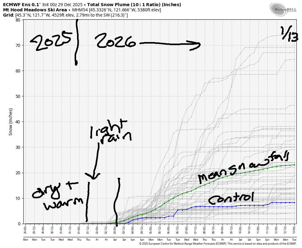
Looking at the range of possible snow totals through the 13th of January, we have the mode somewhere around 8-15” (several clusters), the median around 15”, the mean around 20”, and the intraquartile range of 9.7” to 31.2” total snow. Apparently I’m geeking out on math and statistics this morning! Boiling it down to plain language, there’s not a ton of snow forecast in the next couple of weeks, and the most likely scenario is 20” or less total snowfall over that time period. Ouch. That’s not what we’re supposed to be seeing in a La Nina year! As a matter of fact, the forecast is so mellow for the next several days that I’m going to take tomorrow off.
Short term Mt Hood snow forecast
Looking at Monday, we’ll have partly high overcast sky for Mt Hood. The free air freezing level will be around 8000′ early, 10,000′ this afternoon, and 12,000′ after midnight. Temps at 5000′ max out somewhere between 34F and 48F today (depending on how much of the warmer air can move in). Lower elevations such as Skibowl and Teacup will likely be colder unless the inversion breaks. Wind will be light and variable all day and S 10 after midnight. Snow conditions today: hardpack with some scoured areas.
Tuesday looks sunny. The free air freezing level will be around 12,000′ all day with temps maxing out in the upper 40s at 5000′. Lower elevations, once again, depend on whether the inversion breaks or not. Wind: S 10 in the morning, SW 10 in the afternoon, and W 5-10 overnight. Snow conditions: probably hardpack – this time of year, even warm days don’t have a huge effect due to the sun angle. That’s good, because with the snowpack so thin (25% of normal), we need all the help we can get to preserve it!
Extended Mt Hood Snow Forecast
Wednesday will be partly high cloudy in the morning and clear in the afternoon with high clouds overnight. The free air freezing level will be 12,000′ all day and will fall to 9000′ after midnight. Temps max out in the upper 40s. Wind: W 5-10 in the morning, SSE 10 in the afternoon, and WSW 20 overnight.
Thursday starts with high clouds. Light precip arrives in the afternoon or evening – models are still sussing out the timing. We’re expecting light rain into Friday as the snow level bounces around between 6000′ and 7500′. Wind for the Thursday-Friday period will be SW 15-25. Sometime Friday afternoon (timing isn’t clear), the rain switches over to light snowfall. Beyond that, model uncertainty is high – quite a bit of uncertainty is present about both temps and precipitation quantity/timing. So, I’ll leave it there for now. Get up and get yourself some sunshine and snow this week before clouds return on Thursday. Don’t forget the sunscreen!
Was that helpful? I knew it was! Guess what? All of this crucial work – from your personal wind and snow reports to the invaluable TATAS updates – is made possible by my relentless efforts. Maintaining this labor of love isn’t easy. Each daily forecast takes hours. Website hosting, weather model access, and back-end admin work takes time and money. That’s where you come in.
YOUR CONTRIBUTION MAKES A DIFFERENCE
- SUPPORT ACCURATE, HYPER-LOCAL WEATHER FORECASTING
- ENABLE ACCESS FOR ALL, EVEN THOSE WITH LESS MEANS
- SUPPORT A COOL HUMAN WHO WORKS HARD SO YOU CAN PLAY
Take a moment to click one of the buttons below. Donate $19.99 or more (how much does this forecast enhance your life?) and get the email in your inbox. Whether it’s a renewing subscription (auto-renew) or a one-time donation, every contribution makes a real difference. Help me keep this labor of love alive, so we can all continue playing, commuting, and living in the Gorge with peace of mind and the best weather forecasts possible. Thank you!


Hood River, Oregon 97031


GORGE WIND FORECAST
If you’re still seeing yesterday’s and it’s after 9am, try opening this in an incognito window
SHORT-TERM gorge wind forecast
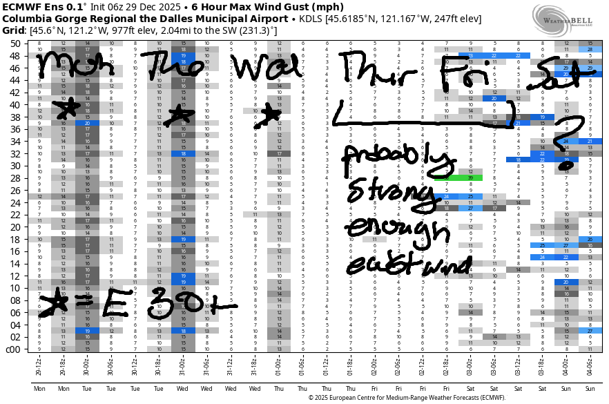
Hi friends! Strong easterlies are in the cards Monday through Wednesday along with high temps in the low 40s. If you’re going for it, dress extra warmly, have an emergency plan, and keep an eye on your buddies.
Monday started off with pressures of 30.51/30.68/30.70 for a robust east gradient of 0.17. Prior to dawn Iwash (Rooster) was reading 45mph, Stevenson 37mph, and Viento 20mph. The wind will hold all day. River flow over the last 24 hours was 186-214kcfs, river temp is 45.5F, and high temp forecast is 40F.
RIVER FLOW FOR SITES BETWEEN AVERY (EAST OF THE DALLES) AND RUFUS: CLICK HERE FOR JOHN DAY DAM FLOW.
RIVER FLOW FOR SITES BETWEEN STEVENSON AND DOUG’S BEACH (WEST OF THE DALLES): CLICK HERE FOR THE DALLES DAM FLOW

LONGER-TERM gorge wind forecast
Tuesday looks a few degrees colder in the morning, but just as windy: 40-45mph at Iwash, 35-40mph at Stevenson, and 20-25mph at Viento. High temp: 39F with sunshine. Wednesday brings slightly lesser, but still strong easterlies: 35-40mph all day at Iwash and 30-35mph all day at Stevenson. High temp: 40F with high clouds.
Easterlies continue on Thursday, but they’ll be down to the 25-30mph range for Iwash with less at Stevenson. We’re also expecting a little bit of drizzle (potentially freezing rain for some spots) sometime during the day, probably in the afternoon. Easterlies continue on Friday in response to a strong low pressure system transiting from south to north along the coast. Beyond that: continued active, messy weather, messy enough that I’ll leave forecasting the wind until the timing of weather features settles out. Stay safe out there the next few days!
BARE BONES HOOD RIVER WEATHER FORECAST
Partly cloudy this morning. Mostly clear later. Temps start in the low 30s and rise to the upper 30s. Light to moderate easterlies. No rainbows. Tuesday will be partly Nothing then clear. Temps start in the upper 20s and rise to the upper 30s. Light to moderate easterlies. No rainbows. Wednesday will be partly Nothing then high cloudy. Temps start in the mid to upper 20s and rise to the upper 30s. Light to moderate easterlies. No rainbows.
TEMIRA’S AWESOME TRAVEL ADVISORY SERVICE
HYPERLOCAL WEATHER FORECAST FOR THE COLUMBIA GORGE
THE DALLES, HOOD RIVER, WHITE SALMON, TROUT LAKE, STEVENSON, CASCADE LOCKS, PARKDALE, ODELL, HUSUM, BZ, MILL A, WILLARD, GOLDENDALE, RUFUS, ARLINGTON, boardman
Good morning, neighbors! Anyone interested in three days of dry weather, potentially with some sunshine? Hopefully you are, because that’s what we’re getting! Do be careful out and about this morning and the next few mornings – black ice is possible, and any areas experiencing the Nothing will have freezing fog and slick roads. As of the time of this report, I hadn’t received any reports of ¡CE in the Gorge, but I’m also uncertain if anyone has been out looking… speaking of looking….
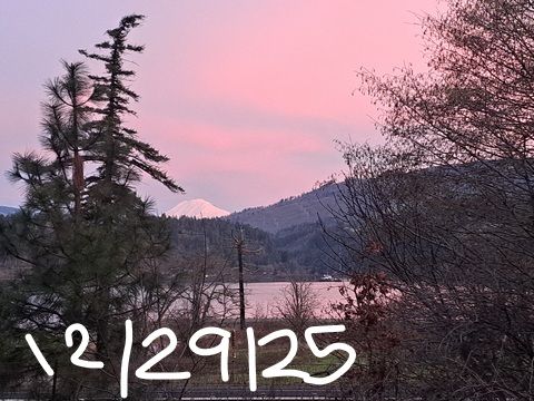
Glenwood this morning
Looking at Monday morning, it’s dark. Sunrise isn’t until 7:46am, and it doesn’t get earlier until January 8th, when sunrise will be 7:45am. Today’s starting chilly thanks to partly clear sky: Glenwood was 24F at 6:30, Trout Lake – 23F, Hood River – 32F, and Cascade Locks 35F thanks to a stiff breeze that was warming the air temp but lowering the wind chill.
Everyone in Glenwood was annoyed by the colder temps in competing communities (GLENWOOD SHOULD BE COLDEST EVERY DAY!), and they were staging a protest for the bottom of Gilhouly Road (23F on Middle Mountain) and in Trout Lake (23F) and Dufur (23F-27F, why are there so many thermometers in Dufur?) When the folks of Glenwood realized how many towns bested them this morning, they said, “F it,” and went back to sipping coffee in the rocking chair in front of the fire.
Today’s Gorge weather forecast
The rest of Monday in the Gorge will be dry with a few high clouds. Temps rise to 40F or so most locations. We’ll see strong easterlies in the usual east wind spots: Iwash holds at 45mph all day, Stevenson at 35mph, and Viento at 20mph. The rest of us are likely to see easterlies at 5-10mph, but hilly areas could see 20mph, which might be enough to form an terrain-enhanced cloud (OROGRAPHICS!!!), freezing fog, and rime ice.
Tuesday / Wednesday Gorge weather forecast
Tuesday kicks off several degrees colder than Monday. It’ll be cold enough that a partial Nothing is likely along the Nch’i Wana from Viento east into the desert. By afternoon: clear sky west of Biggs and potentially lingering Nothing near the river to the east. That Nothing cloud (or fog) way out east could result in slick roads. Be careful if you’re venturing out there or into the Nothing along the hillsides closer to home. Wind: same as on Monday. Temps: same as on Monday. Wednesday looks very, very, very similar to Tuesday other than the fact that the afternoon will have high clouds instead of clear sky.
Extended Gorge weather forecast
Sometime Thursday, this pattern (PROBABLY) dissipates. A weak weather system drags in light precipitation. Depending on the timing of this, light freezing rain may materialize for a few select locations. The possibility of icing continues into early Friday when temps warm enough to convert any precipitation to plain old rain. A couple things to note: 1) any freezing rain is likely to be light; 2) I forgot what I was going to say. Looking deeper into the future, there’s no sign of any significant winter weather impacts. Safe travels. -TATAS
HEY! DON’T STOP READING! Is this community-focused forecast helpful to you? It sure is! It takes me a couple hours a day to write. Please join your friends and neighbors in contributing to keep it going. Venmo: @thegorgeismygym PayPal: twomirrors@gmail.com USPS: Temira / PO Box 841 / Hood River, Oregon 97031 You can test out the forecast subscription for a few days for free by signing up below. Easy! Do it!
JONES BEACH, SAUVIE ISLAND, & COAST FORECAST
ON WINTER VACATION UNLESS DESPERATELY NEEDED.
