

GORGE WIND FORECAST
If you’re still seeing yesterday’s and it’s after 9am, try opening this in an incognito window
today’s gorge wind forecast
Hi friends! Welcome to fall! For the next few days, any wind we get will be frontally driven and impressively unreliable. Next chance for a solid day of west wind is sometime in the Friday/Saturday time frame when there’s some indication of a “classic Gorge setup”. It’s probably going to be Saturday, because I’ll be out of town playing with giant pumpkins all day long.
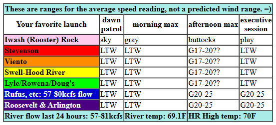
Today won’t be “classic Gorge setup”. Instead, we’ll have a cold front moving through with another, stronger cold front right offshore behind it. Pressures this morning started with 29.78/29.77/29.74 for light onshore gradients. Wind was generally westerly at 5-10mph from Swell eastward, and we had a couple of light/variable or light easterly readings to the west of Swell. As the front arrives late morning or early afternoon, we’ll see westerlies pick up. It’s possible we could luck out with a short period of gusty 17-20mph from Stevenson to Doug’s ahead of the front, but models are not optimistic; they’re keeping the west side at 10mph or less today.
From late morning or early afternoon on, areas east of Doug’s and west of Arlington should see gusty 20-23mph, perhaps gusty 22-25mph. That stronger wind is likely to last perhaps 90 minutes at any given location prior to it shifting farther east. Not a high-probability day by any definition. River flow over the last 24 hours was 57-81kcfs, river temp is 69.1F, and high temp forecast is 70F with drizzle in Hood River after 11am.
RIVER FLOW FOR SITES BETWEEN AVERY (EAST OF THE DALLES) AND RUFUS: CLICK HERE FOR JOHN DAY DAM FLOW.
RIVER FLOW FOR SITES BETWEEN STEVENSON AND DOUG’S BEACH (WEST OF THE DALLES): CLICK HERE FOR THE DALLES DAM FLOW

tomorrow’s gorge wind forecast
A stronger system moves through on Tuesday and gives us a lesser chance of usable wind. The day starts calm, turns easterly at 10mph near Stevenson, and switches to westerly in the afternoon as a cold front and associated rain arrive. Westerlies pick up to gusty 16-19mph from Mosier to Arlington ahead of the front and drop below 10mph as the rain starts. High temp: 68F.
extended Gorge wind forecast
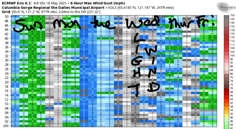
Low pressure offshore sends showers this way again on Wednesday, and that’s not great for wind. The day starts light westerly and turns calm for the morning. Afternoon wind maybe picks up to 15-18mph out of the west from Stevenson to Doug’s, and then it drops again in the evening. High temp: 65F. Showery, less-windy weather is forecast for Thursday.
Sometime in the Friday-Saturday window, there are hints of offshore high pressure rebuilding. That, combined with somewhat warmer desert weather, gives us a shot at a decent day on the river. As I said in the first paragraph, I’ll be out of town all day Saturday dealing with giant pumpkins and hanging with giant pumpkin friends. That makes Saturday the day likeliest to be windy. Enjoy the rain this week. I’ll see you on the Nch’i Wana!
Was that helpful? I knew it was! Guess what? All of this crucial work – from your personal wind and snow reports to the invaluable TATAS updates – is made possible by my relentless efforts. Maintaining this labor of love isn’t easy. Each daily forecast takes hours. Website hosting, weather model access, and back-end admin work takes time and money. That’s where you come in.
YOUR CONTRIBUTION MAKES A DIFFERENCE
- SUPPORT ACCURATE, HYPER-LOCAL WEATHER FORECASTING
- ENABLE ACCESS FOR ALL, EVEN THOSE WITH LESS MEANS
- SUPPORT A COOL HUMAN WHO WORKS HARD SO YOU CAN PLAY
Take a moment to click one of the buttons below. Donate $19.99 or more (how much does this forecast enhance your life?) and get the email in your inbox. Whether it’s a renewing subscription (auto-renew) or a one-time donation, every contribution makes a real difference. Help me keep this labor of love alive, so we can all continue playing, commuting, and living in the Gorge with peace of mind and the best weather forecasts possible. Thank you!


Hood River, Oregon 97031


JONES BEACH, SAUVIE ISLAND, & COAST FORECAST
Wind northerly unless otherwise indicated. For coast, it’s North/Central/South with the “central” at approximately Florence. Swell forecast from NWS for central coast. Jones: westerly unless otherwise stated. Sauvie Island: northerly unless otherwise stated. Coast Monday: SW20/SW20/S15-20, NW swell 9′ at 12 seconds. Tuesday: strong south wind, NW 10′ @ 12. Wednesday: even stronger south wind, W 15′ @ 14. Jones Monday: LTV. Tuesday/Wednesday: rainy easterlies. Sauvie Island Monday: S 10-13. Tuesday: S 13-16+. Wednesday: S14-17+.
BARE BONES HOOD RIVER WEATHER FORECAST
Cloudy this morning with light drizzle midday. Temps start in the low 60s and rise to 70ish. Light westerlies. 79% chance of rainbows. Tuesday will be partly cloudy in the morning with rain in the afternoon. Temps start in the upper 40s and rise to the upper 60s. Light and variable wind turning light westerly. 98% chance of rainbows. Wednesday will be mostly cloudy then partly to mostly cloudy with showers. Temps start near 50 and rise to the mid 60s. Light to moderate westerlies. 99% chance of rainbows.
TEMIRA’S AWESOME TRAVEL ADVISORY SERVICE – MONDAY/TUESDAY
HYPERLOCAL WEATHER FORECAST FOR THE COLUMBIA GORGE
THE DALLES, HOOD RIVER, WHITE SALMON, TROUT LAKE, STEVENSON, CASCADE LOCKS, PARKDALE, ODELL, HUSUM, BZ, MILL A, WILLARD, GOLDENDALE, RUFUS, ARLINGTON, boardman
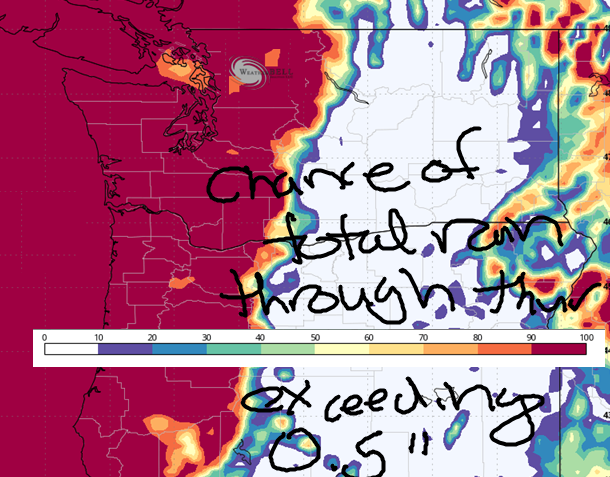
Good morning, neighbors! Our long-awaited pattern change to fall arrives today – you can tell it’s coming by the overcast sky. Out on the coast, it’s raining already. While we’re not going to see a soaking today, we will see a bit of drizzle. Heavier rain is forecast for Tuesday and potentially Wednesday. Fun twist: the snow level will fall as low as 6000′ at times, which should give our mountains a new set of clothes to start the season.
Hello termination dust. Goodbye summer!
Glenwood this morning
Speaking of summer, it’s summery in Glenwood this morning. Thanks to the cloud cover, those folks started the day in the low 50s. Looking at the next few days, 850mb (5000′) temps drop below 8C, cool enough for frost in Glenwood, but that’ll only happen if we can have clear nights, and that’s unlikely. For the rest of us: no chance of frost. Yet.
Today’s Gorge weather forecast
Monday’s going to be a cloudy one. Drizzle arrives midday for the west side and extends as far east as Celilo Village or Biggs by early afternoon. South Wasco also sees drizzle. Areas east of Biggs? No, sorry, none for you, at least not today. Wind will be light early. It rises to maybe 15mph west of The Dalles this morning before dropping below 10mph with the arrival of the rain. East of The Dalles, the wind rises to 20-25mph this afternoon. High temps range from 70F to the west, 75F in The Dalles, and 78F out in the desert.
Tuesday’s Gorge weather forecast
Partly cloudy sky Tuesday morning quickly turns cloudy. Cascade Locks turns wet early afternoon. The Dalles moistens late afternoon. A wee bit of drizzle is possible near the Arlington Triangle after midnight. Travel impact: moderate to heavy rain is possible west of Cascade Locks between 5pm and 11pm. Wind: light/variable most of the day. Max wind will be east of Hood River with 15-20mph in the afternoon. Rainbows: yes, probably. Max temps: 68F to 74F.
Extended Gorge weather forecast
Cooler, showery, rainbow-likely weather is in the cards Wednesday. Showers increase after 2pm thanks to instability generated by surface heating and cold air aloft. How cold? Well, the snow level will be 6000-7000′ on Wednesday! Temps max out at 65F (west), 70F (The Dalles) and 73F (desert). Wind will be light/variable in the morning and evening with westerlies at 15mph between Stevenson and The Dalles early afternoon. Cool, showery weather continues on Thursday. Cool, probably-not-wet weather is forecast for the Friday, Saturday, and Sunday period. After this week’s wetness, the next chance of rain appears to be at the end of next week, and that’s only a maybe for now; starting next Wednesday, the range of possible temps/precip/etc is massive. Ginormous. Mega-huge. Like my pumpkin. Safe travels. -TATAS
HEY! DON’T STOP READING! Is this community-focused forecast helpful to you? It sure is! It takes me a couple hours a day to write. Please join your friends and neighbors in contributing to keep it going. Venmo: @thegorgeismygym PayPal: twomirrors@gmail.com USPS: Temira / PO Box 841 / Hood River, Oregon 97031 You can test out the forecast subscription for a few days for free by signing up below. Easy! Do it!
MT HOOD SNOW FORECAST

CURRENTLY ON VACATION. WILL RETURN SOMETIME BEFORE THE START OF SKI SEASON AT MEADOWS, TIMBERLINE AND SKIBOWL. SAME GOES FOR THE NORDIC SKIING SEASON AT MEADOWS AND TEACUP!
