

GORGE WIND FORECAST
If you’re still seeing yesterday’s and it’s after 9am, try opening this in an incognito window

today’s gorge wind forecast
Hi friends! Pretty morning out there! West wind early this morning fades quickly as high pressure builds inland. Easterlies return for Tuesday and Wednesday. Models hint at west wind potential for both Thursday and Friday, but with lots of rain in the picture, the setup is far from ideal.
Monday started with gradients of 30.34/30.25/30.20 for 0.09/0.05 and plenty of oomph to get you out there. Viento to Swell was 15-18mph, Rowena was reading 21, Rufus 25mph, and we had 15-18mph from Arlington to Threemile. Models are already driving speeds down, especially out near Rufus. That said, there’s enough pressure gradient that an hour or two of 17-20mph from Viento to Swell. Maybe. If we get really lucky. After 1pm, areas west of The Dalles fall to 10mph, and Lyle to Arlington falls to 13-16mph or less. River flow over the last 24 hours was 88-141kcfs, river temp is 53.2F, and high temp forecast is 48F.
RIVER FLOW FOR SITES BETWEEN AVERY (EAST OF THE DALLES) AND RUFUS: CLICK HERE FOR JOHN DAY DAM FLOW.
RIVER FLOW FOR SITES BETWEEN STEVENSON AND DOUG’S BEACH (WEST OF THE DALLES): CLICK HERE FOR THE DALLES DAM FLOW

tomorrow’s gorge wind forecast
High pressure settles inland on Tuesday and turns the wind offshore. We’ll see 25mph at both Stevenson and Iwash in the morning with 20mph at Viento. After 1pm or so, the wind fades to 15-20mph at Stevenson. Iwash drops a little later, but also finishes at 15-20mph. High temp: 42F and cloudy with drizzle after 1pm.
extended Gorge wind forecast
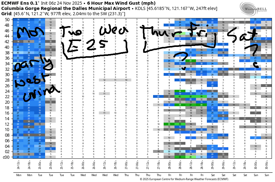
Wednesday starts with 20mph or so at Iwash and Stevenson. The wind holds into the afternoon and picks up to 20-25mph as a low spins offshore. Expect rain after 1pm. High temp: 46F. Westerlies of some sort are possible both Thursday and Friday, but neither looks particularly strong. There are hints of stronger easterlies for the weekend and early next week, but there’s also dramatic uncertainty in the models, so let’s leave it here for now. See you out there!
Was that helpful? I knew it was! Guess what? All of this crucial work – from your personal wind and snow reports to the invaluable TATAS updates – is made possible by my relentless efforts. Maintaining this labor of love isn’t easy. Each daily forecast takes hours. Website hosting, weather model access, and back-end admin work takes time and money. That’s where you come in.
YOUR CONTRIBUTION MAKES A DIFFERENCE
- SUPPORT ACCURATE, HYPER-LOCAL WEATHER FORECASTING
- ENABLE ACCESS FOR ALL, EVEN THOSE WITH LESS MEANS
- SUPPORT A COOL HUMAN WHO WORKS HARD SO YOU CAN PLAY
Take a moment to click one of the buttons below. Donate $19.99 or more (how much does this forecast enhance your life?) and get the email in your inbox. Whether it’s a renewing subscription (auto-renew) or a one-time donation, every contribution makes a real difference. Help me keep this labor of love alive, so we can all continue playing, commuting, and living in the Gorge with peace of mind and the best weather forecasts possible. Thank you!


Hood River, Oregon 97031


MT HOOD SNOW FORECAST

Hey skiers and snowboarders! Still no clear sign of the start of ski season on Mt. Hood. Here’s what we have, generally speaking: a dry Monday is followed by a few days of wet weather Tuesday into Friday. 1.0” to 2.25” precip is forecast with the bulk of that falling as rain. Uncertainty skyrockets Saturday and especially into early next week as models struggle to resolve the possibility of colder arctic air. About 30% of the ensemble members bring in some easterly orographic snowfall Saturday into Sunday. That’s followed by dry weather for much of next week. Model then hint at a return to wetter weather around the 6th of December, but there’s a wide range of temps that are possible in that time period.
Deets for the next few days include… Sunshine on Mt. Hood this morning with high clouds later. The free air freezing level will be around 2500′ all day. Wind: W 35 this morning, W 10 this afternoon, and W 15 overnight. Tuesday starts with high clouds. Precip arrives in the form of snow around 1pm and switches to rain overnight. The free air freezing level will be 2500′ in the morning. When precip arrives, the snow level will be 3500′, but it will rise to 6500′ overnight. We’ll see a trace of snow prior to 4pm, an inch before the snow switches to rain, and upwards of 0.5” rain overnight. Wind: SW 10-15 early, WSW 25-35 in the afternoon, and W 25 overnight.
Wednesday brings intermittent drizzle with a break midday. The snow level will be 6500′ in the morning, 7000′ in the afternoon, and 9000′ overnight. About 0.25” total rain is forecast. On Thursday, temps drop into the afternoon and rain switches to snow. 1-3” is the forecast at 5000′. Additional snow is possible on Friday as a cooler system arrives. Models then hint at the potential for a cold snap with a few inches of easterly orographic snowfall at the start of this. From late Friday on, there’s a lot of uncertainty in the models. What does look clear is that most of next week will be dry. I’ll leave it here for now! Hope to see you on the slopes soon!
BARE BONES HOOD RIVER WEATHER FORECAST
Partly cloudy sky this morning. Partly high cloudy later. Temps start in the mid 40s and rise to the upper 40s. Light to moderate westerlies. No rainbows. Tuesday will be cloudy then drizzly from 1pm on. Temps start in the mid 30s and rise to the low 40s. Light easterlies. 1% chance of rainbows. Wednesday will be cloudy with drizzle early and also after 1pm. Temps start in the mid 30s and rise to the mid 40s. Light easterlies. 71% chance of rainbows.
TEMIRA’S AWESOME TRAVEL ADVISORY SERVICE
HYPERLOCAL WEATHER FORECAST FOR THE COLUMBIA GORGE
THE DALLES, HOOD RIVER, WHITE SALMON, TROUT LAKE, STEVENSON, CASCADE LOCKS, PARKDALE, ODELL, HUSUM, BZ, MILL A, WILLARD, GOLDENDALE, RUFUS, ARLINGTON, boardman

Good morning, neighbors! I’m running late because I’m still catching up on sleep from the nasty GI virus. Again, I recommend you don’t get that one! Let’s look at the weather model output this week and take the focus off the output of my butthole, shall we? Models suggest a wet week. For most of the period, the freezing level stays too high to impact the passes or your travel plans. But not Friday – the snow level falls enough to impact the passes then! Looking at next weekend, impressive uncertainty exists as models struggle to handle the possibility of an outbreak of Arctic air.
Speaking of places that border on arctic… Glenwood was reading 37 degrees this morning, but a nearby sensor was reading 28. That’s what I mean by surface temp inconsistency! Most of us were in the mid 40s this morning with 30s away from the river-level west wind. That wind, which is currently 25mph near Bob’s Texas T-Bone, will fade as the day goes on and finish at 10mph or less all through the Gorge. General weather will be partly cloudy to the west and sunny to the east with increasing high clouds this afternoon. Temps end up in the upper 40s to the west and low 50s from The Dalles eastward.
Incoming clouds lend uncertainty to the overnight temp forecast. We can’t rule out some frost/slick spots in elevated areas, but we can’t rule them in either. Tuesday starts with temps in the low-mid 30s under mostly cloudy sky. Rain arrives mid afternoon and quickly extends all the to The Dalles, skips Avery-Arlington, and picks up again in the far eastern reaches of the Nch’i Wana. Between 4pm and 10pm, expect moderate to heavy rain and messy driving conditions as far east as Rowena. Wind: 20-25mph at Stevenson and Iwash (RELEASE THE UNREDACTED FILES) Rock with light easterlies elsewhere. High temps only make it into the low 40s. Brrrrrrr.
Wednesday starts drizzly as far east as the Arlington Triangle. Rain finishes up around sunrise. Thanks to widespread cloud cover, sunrise rainbows, sadly, are unlikely. Early temps: mid 30s. Afternoon: mid 40s. A second rainy system arrives early afternoon and moves quickly through the Gorge from west to east. This one brings a period of moderate rainfall with it just in time for your evening commute. Wind: 20-25mph at Stevenson and Iwash (schlong) Rock all day.
Showery weather continues Thursday into Friday. On Friday, models have the snow level falling to 3000′ or so with up to half a foot of accumulation at 5000′. So, some snow is possible on the passes. Now we look at next weekend. You may recall that yesterday’s forecast pointed at the outlier GFS deterministic. That silly thing is already regressing toward the mean and letting go of irrational exuberance.
Still… we have massive uncertainty Saturday into the start of next week. Generally speaking, we’re likely to see some colder weather for a couple days, but there’s no way to tell just how cold. By next Tuesday, we have models giving us 850mb temps ranging from -5C to +8C, which is really quite ridiculous. We look at 850mb temps rather than surface temps to judge the air mass as surface temps vary wildly depending on location (Glenwood, I’m looking at you). Generally speaking, despite the wide range of possible temps, models do keep most of next week dry.
The one chance of any snowfall would be if the stronger arctic front materializes late next weekend and wrings some snow out of the marine air mass as it marches westward. Unlikely scenario, but worth keeping in mind. Safe travels. -TATAS
HEY! DON’T STOP READING! Is this community-focused forecast helpful to you? It sure is! It takes me a couple hours a day to write. Please join your friends and neighbors in contributing to keep it going. Venmo: @thegorgeismygym PayPal: twomirrors@gmail.com USPS: Temira / PO Box 841 / Hood River, Oregon 97031 You can test out the forecast subscription for a few days for free by signing up below. Easy! Do it!
JONES BEACH, SAUVIE ISLAND, & COAST FORECAST
ON WINTER VACATION UNLESS DESPERATELY NEEDED.
