

MT HOOD WEATHER FORECAST
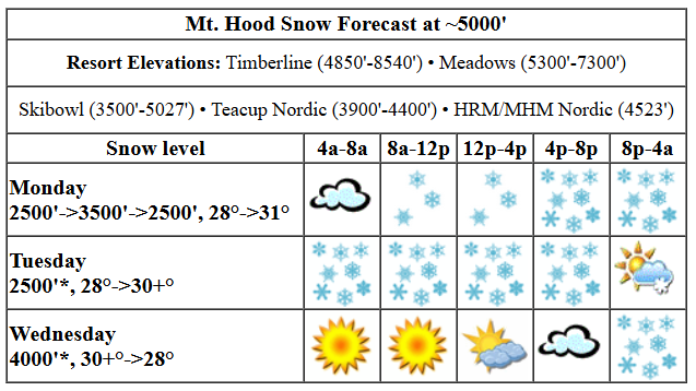
Hey skiers and snowboarders! It’s a pow day on Mt. Hood – my sources up there tell me the snow is “typical northwest pow” at most elevations and “a pain” around 4000′. Another foot of fresh in in the cards today with a bit more tonight. A dry day Tuesday is followed by light mixed precip Tuesday night into Wednesday afternoon when a stronger system comes in. That one’s likely to start at mixed precip and switch to snow with up to a foot of new in the cards. Dry weather is forecast most of the way into Saturday, and then models are increasingly confident on some sort of Pineapple Express event in the Sunday through Tuesday window. More on that in a bit. Snow conditions today: powder with powder-covered packed powder groom.
Monday kicks off snowy and stays that way. The snow level will be 2000-2500′ this morning, 3500′ this afternoon, and 2000′ after midnight. Temps start in the upper 20s, rise to the low 30s, and fall back to the upper 20s tonight. About 0.9” water equivalent (WE) is forecast today for 8-10” of fresh, somewhat dense powder. Overnight, 0.2” WE is in the cards for a couple inches more. Wind will be W 20 this morning, WNW 25-30 this afternoon, and W 15 after midnight. That period of WNW wind could nudge snow totals upward thanks to orographic assistance.
Tuesday kicks off with clouds up to 6500′ or so and clear sky above. Dry, sunny weather sticks around through the afternoon and is followed by high clouds. Precip starts up around 4pm. With temps bouncing around a lot due to cold air to the N/E and warm air to the W/S, mixed precip is likely. It’s quite hard to pin down an precise snow level. Let’s go with temps at 5000′: 28F in the morning, 30-33F in the afternoon, and 30-37F overnight. See the problem?! Fortunately, there’s only 0.2” WE forecast overnight, but that may cause some icing on lifts. Wind: W 15 in the morning, S 10-15 for most of the day and night, then SW 15-25 after midnight.
The warm-air-cold-air struggle continues on Wednesday. Temps: 30-35F in the morning, 28-33F in the afternoon, and 28F overnight. During the day, we’re expecting about 0.2” WE mixed precip. Overnight, models call for 1.2” WE, most of which should come in as snow. Call it 7-9” to be conservative; it may start mixed and cause icing on lifts. Wind: SW 15-25 in the morning, SSW 25-40 in the afternoon, and NW 20-25 after midnight.
Light snow (a few inches total) on Thursday morning gives way to sun in the afternoon. The snow level will be around 2500′ all day and will rise to 6500′ after midnight. Temps start in the upper 20s and rise to the mid 30s overnight. Wind: NW 20-25 in the morning, WNW 15-20 in the afternoon, and light/variable overnight.
Warm, dry weather is in the cards Friday and Saturday, although an inch of two of snow is likely Friday night. Models increasingly like the idea of some sort of warm atmospheric river event in the Sunday-Tuesday time frame. Details, of course, aren’t yet clear. The ECMWF is all-in with a moderate to strong atmospheric river. The GFS isn’t so sure. It’s definitely going to be above freezing; what’s in question at this point is how much rain and the timing of that rain. I’ve proposed “Singing In The Rain” karaoke at the base of MHX at Meadows, but I doubt it’ll actually happen. But hey, gotta make the most of it, right? Have a great pow day today!
Liking this forecast?
Was that helpful? I knew it was! Guess what? All of this crucial work – from your personal wind and snow reports to the invaluable TATAS updates – is made possible by my relentless efforts. Maintaining this labor of love isn’t easy. Each daily forecast takes hours. Website hosting, weather model access, and back-end admin work takes time and money. That’s where you come in.
YOUR CONTRIBUTION MAKES A DIFFERENCE
- SUPPORT ACCURATE, HYPER-LOCAL WEATHER FORECASTING
- ENABLE ACCESS FOR ALL, EVEN THOSE WITH LESS MEANS
- SUPPORT A COOL HUMAN WHO WORKS HARD SO YOU CAN PLAY
Take a moment to click one of the buttons below. Donate $19.99 or more (how much does this forecast enhance your life?) and get the email in your inbox. Whether it’s a renewing subscription (auto-renew) or a one-time donation, every contribution makes a real difference. Help me keep this labor of love alive, so we can all continue playing, commuting, and living in the Gorge with peace of mind and the best weather forecasts possible. Thank you!


Hood River, Oregon 97031


GORGE WIND FORECAST

Hi friends! Not much going on for the next couple of days, but stronger easterlies are possible on Wednesday and westerlies are possible Thursday. Monday kicks off with light offshore gradients. As a system swings through, west wind returns. At best, we’ll see 14-17 from Stevenson to Swell midday with 11-14 to the east. River flow over the last 24 hours was 81-133kcfs, river temp is 38F, and high temp forecast is 47F with rain in the morning and showers in the afternoon and cloudy sky.
Tuesday starts calm. Easterlies rise to 10-15mph at Iwash (Rooster) Rock and Stevenson in the afternoon. They really crank up overnight, but it’ll be dark. High temp: 47F and dry with cloudy sky. Wednesday starts with east wind at 40mph at Stevenson and 45mph at Iwash. The wind falls to 25mph at both places in the afternoon. It’ll be rainy most of the day with a break possible early afternoon. High temp: 44F with cloudy sky. Depending on the path of an incoming low on Thursday, we could see westerlies. Keep an eye on it.
BARE BONES HOOD RIVER WEATHER FORECAST
Rain this morning, showers this afternoon. Temps will be in the mid 30s early and mid 40s later. Light easterlies early. Light westerlies later. 99% chance of rainbows. Tuesday will be cloudy and dry. Temps start in the upper 30s and rise to the upper 40s. Calm wind. No rainbows. Wednesday will be rainy in the morning, dry for a few hours midday, then rainy again. Temps start in the mid 30s and rise to the mid 40s. Light easterlies. 9% chance of rainbows.
TEMIRA’S AWESOME TRAVEL ADVISORY SERVICE
HYPERLOCAL WEATHER FORECAST FOR THE COLUMBIA GORGE
THE DALLES, HOOD RIVER, WHITE SALMON, TROUT LAKE, STEVENSON, CASCADE LOCKS, PARKDALE, ODELL, HUSUM, BZ, MILL A, WILLARD, GOLDENDALE, RUFUS, ARLINGTON, boardman
Good morning, neighbors! It’s another fine winter morning – gray, wet, with freezing rain for a few select folks out there. With west wind in the cards this afternoon, we should all pop above freezing later. Next found of fun is Wednesday morning when evaporative cooling might just take the snow level back down low for a few hours. Thursday and Friday are boring enough that we can ignore them. Warmer air streams in from the SW for the weekend, and a Pineapple Express is in the cards for Sunday through Tuesday, maybe. Probably.
glenwood & the tatas eootd
Let’s check in with Glenwood: it’s 33F there this morning. That is all. TATAS Executive Order Of The Day: contraceptive supplies shall be free and readily accessible to all and covered by health insurance. Signed with Astroglide.
monday, aka today
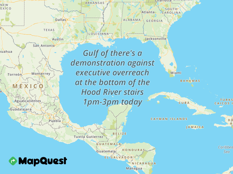
Today’s weather: this morning brings freezing rain to our cold areas. That includes Parkdale, High Prairie, Dufur, Trout Lake, Centerville, and potentially parts of Odell, BZ, Goldendale, and the Dry Hollow area. Temps should warm enough to switch the icing to plain rain today, but temps will likely drop just enough tonight for a return to slick roads. Down lower… If you’re going to the 50501 pro-democracy, anti-executive-branch-overreach demonstration today at the bottom of the Hood River stairs, you’ll want a rain coat. See what I did there? Actually, by that point in the day, we’ll just be seeing intermittent showers (and rainbows) as far east as Rowena. That continues overnight. SW/Sherm dry out after 10am. Temps today, thanks to west wind, rise to the mid/upper 40s along the river. Those westerlies pick up to 15mph or so this afternoon from Stevenson to Hood River with 10mph or so as far east as Large River Blocking Construction Object John Day.
tuesday
Clouds stick around in the west Monday night, and a few breaks in the clouds pop up to the east. Tuesday will be a mostly cloudy day with a few showers west of Hood River until dawn. Get shit done cuz the day will be dry! Overnight, rain returns as far east as Rowena. But wait! Some models hint at cold air surging back into the Gorge late in the day Tuesday for mixed precip overnight.
wednesday
It could be just cool enough Tuesday night, and the precip could be just strong enough, for sloppy wet snow down to river level Wednesday morning. Maybe. It’s gonna be right on the edge. Some select areas could even see a little freezing rain. Either way, Wednesday will be wet everywhere until mid-morning. A break late morning to early afternoon is followed by another, wetter system in the afternoon. This one, should it materialize as currently forecast, will dump pouring rain west of Mosier for a nasty commute home from the city. Wind: E 40-45 at Stevenson and Iwash in the morning and E 25 in the afternoon.
thursday and beyond
Models hint, once again, at sloppy, slushy snowfall Wednesday night into Thursday. I’m currently skeptical, but let’s look again as we get closer. Most of Thursday will be dry. Ditto on Friday. Light rain is forecast Friday night into Saturday with dry weather Saturday daytime. On Sunday, the southern edge of an atmospheric river slides south and brushes us like a feather caressing a butthole. Wet weather (probably) sticks around through Tuesday; models aren’t fully in agreement on the aim of that atmospheric river fire hose, but the Euro sure wants us to take the brunt of it. Wet or not wet, drenching or just damp, this setup will bring warmer, moist air to the Gorge. Snow levels rise well above the passes. 50ish degree weather looks to stick around all next week. Normal average highs along the river next week: 48F, which is warmer than I thought. Huh. Safe travels. -TATAS
HEY! DON’T STOP READING! Is this community-focused forecast helpful to you? It sure is! It takes me a couple hours a day to write. Please join your friends and neighbors in contributing to keep it going. Venmo: @thegorgeismygym PayPal: twomirrors@gmail.com USPS: Temira / PO Box 841 / Hood River, Oregon 97031 You can test out the forecast subscription for a few days for free by clicking this link: https://subscribepage.io/YhevGc
