

MT HOOD WEATHER FORECAST
Hey skiers and snowboarders! A mellow week of mt hood weather – mostly dry with intermittent clouds and maybe an inch or two of snow early in the week – gives you a chance to simply cruise around on the groom. This sets us up for a cold, snowy period next week. Models aren’t in agreement in how long that’ll last, but they do think there’s quite a bit of fresh snow in our future starting next Monday. But that’s a week out. Let’s look at what we have today: mostly granular conditions on the slopes and plenty of sun.
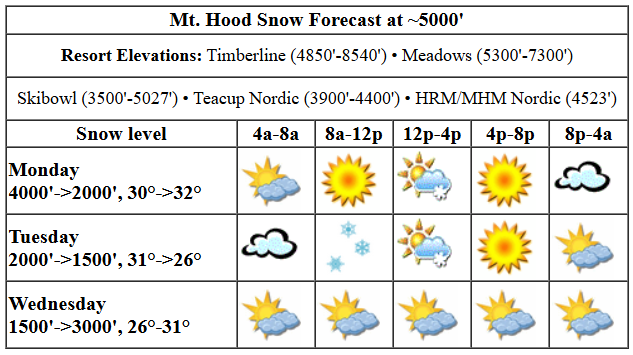
Monday kicked off with clouds, fog, and granular groom, but the sun will come out. The free air freezing level will be 4000′ this morning, 3000′ this afternoon, and 2000′ overnight. The temp at 5000′ starts at 30F, falls a couple degrees in the evening,a and rises back to 32F or so overnight. We can’t rule out a trace of snow midday, but we also can’t rule it in. Wind today will be NW 20-30 early, W 20 in the afternoon, and SW 10-15 after midnight.
Tuesday looks high overcast to start, snowy mid-morning, clear in the afternoon, and cloudy with a trace of snow possible overnight. The snow level will be around 4000′ in the morning, 2500′ in the afternoon, and 1500′ overnight. Temps start around 31-32F and fall to the mid 20s by the afternoon. Just an inch or so of snow is forecast during the day. A trace is forecast overnight. Wind will be SW 10-15 early building to WSW 30-35 in the afternoon and fading to W 15 after midnight.
extended mt hood weather forecast
Wednesday will be partly high overcast and dry. The free air freezing level starts around 1500′, climbs to 3000′ in the afternoon, and falls back to 2500′ after midnight. Temps will be in the mid 20s early and upper 20s to low 30s later. Wind: W 15 in the morning, light/variable in the afternoon, and E 20 after midnight. Looking longer-range, Thursday, Friday, and Saturday look cool and dry. Sunday is starting to look dry as well. After that: colder with snow, yay! Have a great day on the snow!
Was that helpful? I knew it was! Guess what? All of this crucial work – from your personal wind and snow reports to the invaluable TATAS updates – is made possible by my relentless efforts. Maintaining this labor of love isn’t easy. Each daily forecast takes hours. Website hosting, weather model access, and back-end admin work takes time and money. That’s where you come in.
YOUR CONTRIBUTION MAKES A DIFFERENCE
- SUPPORT ACCURATE, HYPER-LOCAL WEATHER FORECASTING
- ENABLE ACCESS FOR ALL, EVEN THOSE WITH LESS MEANS
- SUPPORT A COOL HUMAN WHO WORKS HARD SO YOU CAN PLAY
Take a moment to click one of the buttons below. Donate $19.99 or more (how much does this forecast enhance your life?) and get the email in your inbox. Whether it’s a renewing subscription (auto-renew) or a one-time donation, every contribution makes a real difference. Help me keep this labor of love alive, so we can all continue playing, commuting, and living in the Gorge with peace of mind and the best weather forecasts possible. Thank you!


Hood River, Oregon 97031


GORGE WIND FORECAST

Hi friends! West wind is on tap today, but it’s going to be right on the edge for the paddle crew at the paddle places. Lesser wind is forecast Tuesday and Wednesday. Ensembles have some hint of wind on Thursday, but it’s far from certain. Remember, there’s always dock starting! Okay, Monday started with pressures of 30.11/30.01/29.96 for gradients of 0.10 and 0.05. That’s a good indicator for Lyle-Rufus. Models push high pressure inland this afternoon. That’ll knock down the wind speed starting from the west and moving east. Morning wind will be 13-16 from Viento to Mosier with 17-20 from Lyle to Rufus. Mosier-Doug’s cranks up late morning or early afternoon to 25-28. Rufus follows suit an hour or two later. The wind eventually fills in at 25-28 all the way to Threemile. By that time, areas west of Lyle (or perhaps west of Mosier) will have dropped to 10-13 or so. River flow over the last 24 hours was 109-151kcfs, river temp is 39.74F, and high temp forecast is 53F.
Tuesday looks pretty marginal. The day starts with E 15mph at Stevenson and Iwash (Rooster) Rock. The wind turns westerly late afternoon with 11-14 from Stevenson to Hood river, light wind from Mosier to Doug’s, and potentially (but not certainly) 19-22 from Avery to Rufus. Farther east: nothing. Wednesday starts dead calm and builds to E 10-15 all through the Gorge. Some ensemble members suggest eastern Gorge westerlies on Thursday, but that’s far from guaranteed. Let’s leave it there for now. Have a great day on the river today!
BARE BONES HOOD RIVER WEATHER FORECAST
Mostly cloudy sky this morning. Partly cloudy later. Temps start in the upper 40s and rise to the low 50s. Moderate westerlies. No rainbows. Tuesday will be cloudy and drizzly in the morning and mostly clear in the afternoon. Temps start in the upper 30s and rise to the upper 40s. Light easterlies early. Light westerlies later. 79% chance of rainbows. Wednesday will be mostly cloudy then mostly clear. Temps start in the mid 30s and rise to the low 50s. Calm wind early. Light easterlies later. No rainbows.
TEMIRA’S AWESOME TRAVEL ADVISORY SERVICE
HYPERLOCAL WEATHER FORECAST FOR THE COLUMBIA GORGE
THE DALLES, HOOD RIVER, WHITE SALMON, TROUT LAKE, STEVENSON, CASCADE LOCKS, PARKDALE, ODELL, HUSUM, BZ, MILL A, WILLARD, GOLDENDALE, RUFUS, ARLINGTON, boardman
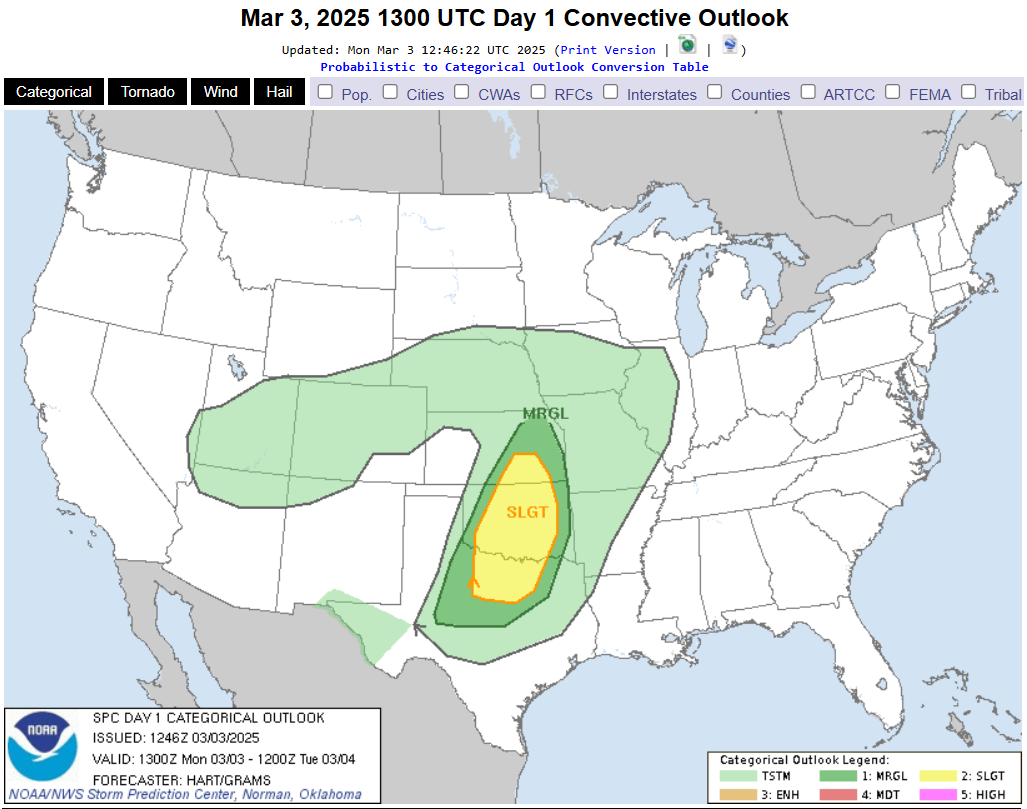
Good morning, neighbors! Ah, false spring. Enjoy it while it’s here all week. We’re back to cold and wet starting a week from today. Probably. You know how these extended forecasts are, but the ensembles are pretty certain. Thank goodness for those government-funded models and all the NOAA mathematicians who design and program them and all the NOAA sensor readings that provide the initial conditions on which those models run! We also need NOAA for the SPC, which tells us today that there’s a slight risk of severe thunderstorms centered on Oklahoma today. Don’t go getting, ahem, testy about that. The risk of regular old thunderstorms continues, uncut, all the way into Utah and Arizona with just the tip of the instability reaching Nevada.
glenwood & TATAS eootd
Let’s check in with the D7759 sensor, aka Glenwood: 32 degrees this morning with a dewpoint of 26, and sunny, as best I can tell. TATAS Executive Order Of The Day: carbon credit markets shall be set up in this country. Now. They shall be set up now. Signed with a black coal pencil, of course.
monday
It’s Monday, and it’s time for … sunshine! East of Mosier, it’ll be sunny all day. To the west, clouds break up as the day goes on. There will be no tears from this breakup. Just sunshine. See – some breakups are a good thing. Temps rise to the low 50s down low. Westerlies will be 10-15mph from Stevenson to Mosier with a slow build to 20-30mph from Lyle to Threemile Canyon.
tuesday
High clouds move in tonight. If they’re early, nobody drops below freezing tonight. If they’re late, radiational cooling drops our colder areas below freezing. Precip arrives as far east as Lyle around daybreak Tuesday. We can’t rule out wet snowflakes up high early in the morning, but there’s just not enough available moisture to cause much snow buildup. Drizzle is forecast as far east as the Arlington Triangle and SW/Sherm through noon or so. After that, the rain backs up to Lyle (and the WA hills) through mid afternoon. Cascade Locks sees drizzle into the evening. Tuesday’s wind will be E 15mph at Stevenson and Iwash (dick) Rock in the morning with westerlies at 10-15mph from Stevenson to Hood River and 15-25mph from Avery to Rufus in the afternoon. High temp: 50ish.
wednesday and beyond…
Wednesday looks mostly cloudy then mostly clear. High temp: 53 or so. Wind: east 15mph in the usual spots and E 5-10mph east of Mosier. Thursday, Friday, Saturday, and potentially Sunday look dry and mild with high temps in the low 50s. OH MY GOD SO MUCH GOOD GARDENING WEATHER! Don’t be getting all excited about spring like those daffodil shoots popping up everywhere or like the boners on all the little animals impregnating each other in time for spring births. Winter returns next week. It probably won’t be cold enough to snow at river level. With ensembles calling for 850mb temps at -3C to -5C, we can’t rule out snow above 1000′. Can’t rule it in either. Safe travels. -TATAS
HEY! DON’T STOP READING! Is this community-focused forecast helpful to you? It sure is! It takes me a couple hours a day to write. Please join your friends and neighbors in contributing to keep it going. Venmo: @thegorgeismygym PayPal: twomirrors@gmail.com USPS: Temira / PO Box 841 / Hood River, Oregon 97031 You can test out the forecast subscription for a few days for free by clicking this link: https://subscribepage.io/YhevGc
