

MT HOOD WEATHER FORECAST
Hey skiers and snowboarders. Wow… the system forecast to just barely brush us over the last 24 hours did a lot more than that! Mt Hood weather… it’s gonna do what it’s gonna do sometimes! Models were calling for about 0.25” of rain in that period, and instead we picked up 2.0” of rain. Given that we’re expecting warm weather for the next few days, that’s a good thing for the snow surface – it’s way less likely to be sticky if it’s fully and completely saturated. Today: wet pack. So, after a three day break for a brief period of spring, we’ll be right back to winter with snowfall by late Thursday with just-cold-enough, wet weather in the forecast for much of the extended period. I’m taking off for a month-long silent retreat on April 1, and I’ll see you again the first week of May.
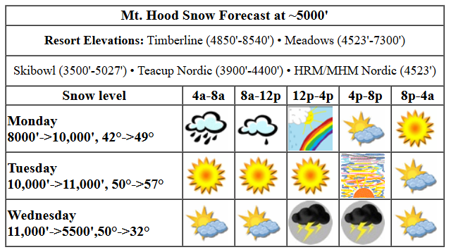
monday’s mt hood weather
Monday kicks off with rain, but by the afternoon it will be partly cloudy, and overnight the sky will clear. The snow level will be around 8000′ this morning, and the freezing level will slowly rise to 10,000′ overnight. Models say we’re only expecting another 0.1” rain today, but it’s been raining almost 0.2”/hr the last couple hours and there’s more rain on the radar. I’m skeptical of that 0.1” forecast and am delaying my skating for a couple hours. By afternoon, we’ll have partly cloudy sky. Temps at 5000′ start in the low 40s and rise to nearly 50F today. Wind: WSW 25 this morning, SW 10-20 this afternoon, and SW 5-10 tonight.
Tuesday’s mt hood weather
Tuesday will be sunny in the morning with sun filtered through high clouds in the afternoon. The free air freezing level rises from 10,000′ in the morning to 11,000′ in the evening. Temps start around 50F and rise to the upper 50s. Wind will be SW 5-10 all day and S 10-20 overnight.
wednesday’s mt hood weather
Wednesday kicks off clear, but completely destabilizes in the afternoon. Thunderstorms are possible in this highly unstable environment. It’s likely that resorts will experience lightning, which will cause lifts to shut down. The snow level with any accompanying precip (and there’s a LOT of available moisture) will be 11,000′ in the morning, 9500′ in the afternoon, and 5500′ after midnight. No way to guess how much precip will fall. Wind: southerly to SW with any sort of wind speed and direction possible in storms. Not the greatest afternoon to be on the slopes, for sure!
extended mt hood weather forecast
Dry weather Thursday morning gives way to wet/dense snow in the afternoon. Snow continues into Friday and cuts out by afternoon. There’s some disagreement still in the forecast for next weekend, so we’ll leave it here for now. Stay dry out there, and I”ll see you on the snow!
Was that helpful? I knew it was! Guess what? All of this crucial work – from your personal wind and snow reports to the invaluable TATAS updates – is made possible by my relentless efforts. Maintaining this labor of love isn’t easy. Each daily forecast takes hours. Website hosting, weather model access, and back-end admin work takes time and money. That’s where you come in.
YOUR CONTRIBUTION MAKES A DIFFERENCE
- SUPPORT ACCURATE, HYPER-LOCAL WEATHER FORECASTING
- ENABLE ACCESS FOR ALL, EVEN THOSE WITH LESS MEANS
- SUPPORT A COOL HUMAN WHO WORKS HARD SO YOU CAN PLAY
Take a moment to click one of the buttons below. Donate $19.99 or more (how much does this forecast enhance your life?) and get the email in your inbox. Whether it’s a renewing subscription (auto-renew) or a one-time donation, every contribution makes a real difference. Help me keep this labor of love alive, so we can all continue playing, commuting, and living in the Gorge with peace of mind and the best weather forecasts possible. Thank you!


Hood River, Oregon 97031


GORGE WIND FORECAST

Hi friends! Very active weather continues for much of the extended period, and that leaves us without a reliable chance of wind other than easterlies on Tuesday. Best chance for westerlies in the next week or so is Wednesday, but atmospheric instability will be off the charts with thunderstorms likely. Monday starts with a system moving through and high pressure building inland behind it. Our day started with pressures of 30.20/30.16/30.11 for light onshore gradients. Models suggest westerlies at 12-15 from Avery to Arlington this afternoon and less than 10mph in the western Gorge. River flow over the last 24 hours was 103-173kcfs, river temp is 45.1F, and high temp forecast is 66F with decreasing clouds.
Tuesday sees gradients turn offshore as a weak heat low sets up on the west side. Peak wind will be 25mph at both Iwash (Rooster) Rock and Stevenson midday before dropping to 15-20mph after 2pm at both spots. High temp: 72F with sun in the morning and high clouds later. Yes! Wednesday starts with easterlies at 20-25mph and switches to westerlies after 5pm. Given the massive atmospheric instability, it’s not even worth guessing at the strength of the westerlies – they’ll probably involve thunder, lightning, and hail. High temp: 71F, in theory. Beyond that, there’s no clear sign of a river-worthy day. I was hoping to get one more in before heading out on retreat for April, but it’s not looking hopeful!
BARE BONES HOOD RIVER WEATHER FORECAST
Rain this morning gives way to partly cloudy sky this afternoon. Temps start in the low 50s (record high-low) and finish in the mid 60s. 59% chance of rainbows. Tuesday will be partly Nothing then sunny then high overcast. Temps start in the upper 40s and rise to the low 70s. Muggy. Moderate easterlies. No rainbows. Wednesday will be partly high overcast and then quite unstable with thunderstorms likely. Temps start in the low 50s and rise to the low 70s. Light easterlies. Then moderate westerlies. 99% chance of rainbows.
TEMIRA’S AWESOME TRAVEL ADVISORY SERVICE
HYPERLOCAL WEATHER FORECAST FOR THE COLUMBIA GORGE
THE DALLES, HOOD RIVER, WHITE SALMON, TROUT LAKE, STEVENSON, CASCADE LOCKS, PARKDALE, ODELL, HUSUM, BZ, MILL A, WILLARD, GOLDENDALE, RUFUS, ARLINGTON, boardman
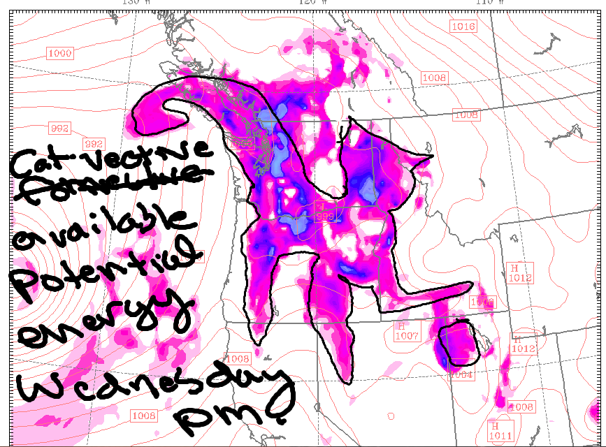
Good morning, neighbors! Just hold on a few more hours, okay? The warm, sunny weather is coming. As an added bonus, we’ve got a darn good chance of thunderstorms on Wednesday, especially out in the desert. Storm Prediction Center (part of NOAA) has us under a marginal risk of severe storms that day, and the CAPE forecast for Pendleton is intense.
glenwood and the federal agency of the day
Before we dive in, let’s check in with Glenwood: 50 degrees with 0.2” rain in the last 24 hours. Compare that to 2.29” rain at Mt. Hood Meadows in the last 24 hours. Federal Agency of The Day: Storm Prediction Center – “Our mission is to provide timely and accurate forecasts and watches for severe thunderstorms and tornadoes over the contiguous United States”. Their job has become much more difficult due to funding cuts resulting in decreased sounding balloon launches in the Midwest. Why do we care? Because models are initialized on data from those sounding balloons, and without all those data points, model accuracy plummets. Speak up for the SPC and its parent NOAA!
monday’s gorge weather
Monday’s weather: models keep the drizzle coming for a few hours this morning. Cascade Locks stays damp through early afternoon, and the South Wasco area picks up some showers this afternoon. Elsewhere, rain stops, and the sky turns partly high overcast. Temps today max out in the upper 60s. Wind will be less than 10mph all day west of The Dalles and will peak around 15mph east of The Dalles.
tuesday’s gorge weather
Overnight, the sky clears. Given that the atmosphere is currently as moist as (mind out of the gutter) the loaf of bread I baked yesterday, we’ll probably see some low-level fog and Nothing away from the east wind zone. By midday, we’ll have sunshine. The sunbeams lose power in the afternoon as high clouds drift in, but still, we’re looking at high temps in the low 70s with the dewpoint in the mid 50s. MUGGY! Wind will be E 20-25 at Iwash (pee-pee) Rock and Stevenson in the morning and 15-20mph in the afternoon. Elsewhere, light easterlies. Hills: light SW wind. Looks like a damned fine morning for spraying!
wednesday’s exciting gorge weather
Wednesday looks very exciting. Excitement, in this case, is predicated on sunbreaks. Those will be most plentiful east of the Cascade Crest, but they’re likely all across the land. Without diving too far into the details… impressive atmospheric instability and wind shear is forecast, and that’s a recipe for thunderstorms. We’re under a marginal risk for severe storms per the SPC; “marginal risk” has resulted in tornadoes in the metro area in the past. More likely: thunder, lighting, random pouring rain, and large hail, especially out in the desert where instability is greatest. High temps are forecast to reach the low 70s, but any downpours will knock temps way down. And downpours are likely in this saturated atmosphere: The dewpoint will be 56-58F all the way out into the desert. MUGGY! Wind-wise, it’ll be easterlies at 15-20mph in the usual east-wind spots in the morning. Anything could happen in the afternoon as thunderstorms generate their own (potentially strong) wind. Mark your calendars for this one.
extended gorge weather forecast
Starting Thursday, we’re back into cool, damp weather with rain in the lowlands and snow in the mountains. There’s a hint of a dry window next weekend, potentially long enough for orchardists to get their spray on.
valuable advice for gardeners inhabiting neighboring areas
Valuable Advice for Gardeners Inhabiting Neighboring Areas: the next couple of days look great for getting seeds in the ground. Take your soil temp and consult a chart, as my advice is for my garden location and elevation. If the soil temp is over 40F, you can start planting cool weather stuff like lettuce and arugula. With the long-range forecast looking 50F and damp, Mother Nature will do the watering for you, which is awesome, because twice-daily watering of germinating seeds sucks. I’m going to go ahead and plant my onion starts this week (mostly because I’m going to be gone for a month). Happy gardening. Safe travels. -TATAS
